applsci-logo

Journal Browser

Journal Browser

Advances in Theoretical and Applied Geophysics

A topical collection in Applied Sciences (ISSN 2076-3417). This collection belongs to the section "Earth Sciences".

Viewed by 7958

Editor


E-Mail Website1 Website2
Collection Editor
Section of Geophysics-Geothermy, Department of Geology and Geoenvironment, National and Kapodistrian University of Athens, Zografou, 15784 Athens, Greece
Interests: geophysics; earth physics; seismology; applied geophysics
Special Issues, Collections and Topics in MDPI journals

Topical Collection Information

Dear Colleagues,

The Topical Collection of Advances in Theoretical and Applied Geophysics is an international and interdisciplinary forum for the publication of results and discussions regarding the Earth’s interior geophysical research, covering the entire multitude of scientific geophysical methods aiming to understand deep and shallow processes in various tectonic settings and acting at different geophysical times and lengths.

Advances in Theoretical and Applied Geophysics invites high-quality research papers, express letters and invited review papers on all aspects of theoretical, computational, experimental, applied and observational geophysics.

The focus of this Topical Collection of Applied Sciences is to promote our understanding of the geophysical processes operating in, on, and around the Earth, and their evolution. Contributions are welcome on all aspects of:

  • Elastic waves in the Earth, Earth's internal structure;
  • Observational and theoretical aspects related to earthquake occurrence (seismotectonics, seismicity, historical seismicity, seismic source physics, strong ground motion studies, Earthquake Early Warning Systems, seismic and tsunami hazard or risk, engineering seismology, physics of fault systems, triggered and induced seismicity, mining seismology, volcano seismology, earthquake prediction, structural investigations ranging from local to regional and global studies);
  • Recent advances observational and theoretical aspects related to Applied Geophysics (seismic and electromagnetic exploration, magnetotellurics, archeogeophysics, inversion techniques, time–domain electromagnetics, radar, electrical resistivity tomography and induced polarization, spontaneous potential), nuclear magnetic resonance) and addressing environmental, engineering, and hydrogeological issues;
  • Natural magnetism over all temporal and spatial scales, and solid-Earth electromagnetic processes related to natural or artificial sources, as applied to problems across the Earth, environmental and planetary sciences; 
  • Thermal processes in the Earth, petrophysic and Earth’s materials, laboratory measurements of physical parameters of crustal and mantle rocks, and their application to geophysics;
  • Satellite techniques to study the Earth’s surface (satellite geodesy, interferometry, gravity) to solve geophysical problems are welcome.
  • Geophysical geodynamics, mantle geodynamics, plate tectonic processes, crustal and mantle rheology, geodynamics of magma transport, rheology and numerical modelling of geodynamic processes;
  • Artificial intelligence and machine learning in geophysics;
  • Remote sensing and big data applications in geophysics;
  • Geophysical instrumentation.

Whenever possible, we encourage use of reproducible methods, and sharing of the computer codes and associated data.

Prof. Dr. Filippos Vallianatos
Collection Editor

Manuscript Submission Information

Manuscripts should be submitted online at www.mdpi.com by registering and logging in to this website. Once you are registered, click here to go to the submission form. Manuscripts can be submitted until the deadline. All submissions that pass pre-check are peer-reviewed. Accepted papers will be published continuously in the journal (as soon as accepted) and will be listed together on the collection website. Research articles, review articles as well as short communications are invited. For planned papers, a title and short abstract (about 100 words) can be sent to the Editorial Office for announcement on this website.

Submitted manuscripts should not have been published previously, nor be under consideration for publication elsewhere (except conference proceedings papers). All manuscripts are thoroughly refereed through a single-blind peer-review process. A guide for authors and other relevant information for submission of manuscripts is available on the Instructions for Authors page. Applied Sciences is an international peer-reviewed open access semimonthly journal published by MDPI.

Please visit the Instructions for Authors page before submitting a manuscript. The Article Processing Charge (APC) for publication in this open access journal is 2400 CHF (Swiss Francs). Submitted papers should be well formatted and use good English. Authors may use MDPI's English editing service prior to publication or during author revisions.

Keywords

  • geophysical imaging
  • physics of the Earth’s interior
  • applied, environmental and engineering geophysics
  • satellite techniques
  • earthquakes
  • seismic waves
  • geoelectromagnetisms
  • geothermodynamics, geodynamics
  • Earth’s rheology
  • artificial intelligence and machine learning in geophysics

Published Papers (5 papers)

2024

Jump to: 2023

20 pages, 25498 KiB  
Article
Design of Three-Dimensional Electrical Impedance Tomography System for Rock Samples
by Xin Peng, Shaoheng Chun, Benyu Su, Rujun Chen, Shenglan Hou, Chao Xu and Haojie Zhang
Appl. Sci. 2024, 14(4), 1671; https://doi.org/10.3390/app14041671 - 19 Feb 2024
Viewed by 1470
Abstract
Research on the electrical properties of rocks and ores plays a crucial role in the development of geophysical electromagnetism methods. However, currently available instruments suffer from high power consumption, a limited number of electrodes, inaccurate measurements, poor portability, and a limited ability to [...] Read more.
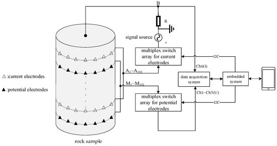
Research on the electrical properties of rocks and ores plays a crucial role in the development of geophysical electromagnetism methods. However, currently available instruments suffer from high power consumption, a limited number of electrodes, inaccurate measurements, poor portability, and a limited ability to measure the electrical parameters of rocks and ores. To address these issues, this paper presents a three-dimensional electrical impedance tomography system for rock samples with high-density microelectrodes based on an Android system and STM32 microcontroller. The system features high observation accuracy, dense electrode arrays (with 384 current and potential electrodes), flexible electrode selection, user-friendly human–computer interaction, good stability, and real-time performance. Powered by a single power bank, the entire instrument can be controlled and monitored wirelessly via Bluetooth and Wi-Fi technology using an Android smartphone. Additionally, the system not only enables accurate measurement of electrical parameters, but also facilitates the generation of three-dimensional impedance imaging of specimens via inversion algorithms after data export, allowing for a comprehensive understanding of the electrical properties of rocks and ores. This system holds great potential for future research in this field. Full article
Show Figures

Figure 1

2023

Jump to: 2024

22 pages, 10544 KiB  
Article
Evaluation of the Possibilities Validation of Interval Velocity Models Using Non-Seismic Data and Its Impact on Geological Interpretation of PreSDM Results
by Michał Stefaniuk, Adam Cygal, Tomasz Maćkowski, Michał Martuś, Piotr Hadro, Krzysztof Pieniądz and Anna Maria Wachowicz-Pyzik
Appl. Sci. 2023, 13(17), 9971; https://doi.org/10.3390/app13179971 - 4 Sep 2023
Viewed by 886
Abstract
The paper presents the problem of generation and validation of Velocity Interval Depth (VID) models with the application of non-seismic geophysical and geological data. The study area is a part of the Carpathian Foredeep located close to its contact with the Carpathian Overthrust. [...] Read more.
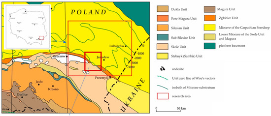
The paper presents the problem of generation and validation of Velocity Interval Depth (VID) models with the application of non-seismic geophysical and geological data. The study area is a part of the Carpathian Foredeep located close to its contact with the Carpathian Overthrust. In this area of complicated geological structure, hydrocarbon deposits have been successfully explored for decades with seismic methods and drilling. The research applied the Simultaneous Joint Inversion (SJI) of independent geophysical data, which is a modern methodology of geophysical data processing, that is still under development. Such an attempt was necessary due to the lack of a sufficiently dense grid of wells in the study area, in which seismic velocities would be correctly recorded. Such data would be then applied for the generation of relevant VID models, which in turn, could be used to perform the Prestack Depth Migration (PreSDM) procedures. The application of procedures taking advantage of independent geophysical and geological data enabled researchers to control the generation process of the spatial VID model in the areas without wells. The analyses aimed to verify the correctness of VID model evaluation and its influence on the quality of seismic imaging in the area of the Carpathian Overthrust. Precisely, the influence was tested of such non-standard generation procedure of seismic velocity fields, not only on the PreSDM results but also on the geological interpretation of both the Rączyna and the Jodłówka gas deposits. The latter aspect of the presented results seems to be crucial to the effectiveness of petroleum exploration in the transition zone between the Carpathian Orogen and the Carpathian Foredeep. Full article
Show Figures

Figure 1

15 pages, 21912 KiB  
Article
Inverse Q-Filtering as a Tool for Seismic Resolution Enhancement: A Case Study from the Carpathian Foredeep
by Artur Piotr Łapinkiewicz, Michał Martuś, Anna Wachowicz-Pyzik, Adam Cygal, Tomasz Maćkowski and Michał Stefaniuk
Appl. Sci. 2023, 13(15), 8564; https://doi.org/10.3390/app13158564 - 25 Jul 2023
Viewed by 1155
Abstract
In this study, we analyze the quality factor- Q derived from the Vertical Seismic Profiling (VSP) and sonic log data that was performed in the DS-2 borehole located in the Carpathian Foredeep. We use the obtained quality factor distributions in the inverse Q-filtering [...] Read more.
In this study, we analyze the quality factor- Q derived from the Vertical Seismic Profiling (VSP) and sonic log data that was performed in the DS-2 borehole located in the Carpathian Foredeep. We use the obtained quality factor distributions in the inverse Q-filtering (IQF) procedure during active seismic data processing. Another very important and, unfortunately, subjective in nature parameter is the gain function applied to seismic data while performing the IQF. To calculate Q from VSP data we use an iterative approach to the spectral ratio method where we use several shallowest receivers as reference. We observe high variability of the obtained Q values, depending on the reference receiver, however, depth distribution of Q was consistent regardless To increase reliability of the obtained values, an additional method of Q measurements is incorporated, i.e., acoustic travel time dispersion method. We show that incorporating inverse Q-filtering to active seismic data processing flow allows to enhance the vertical resolution of 2D seismic data. Full article
Show Figures

Figure 1

15 pages, 81915 KiB  
Article
Unconventional Arrays for 3D Electrical Resistivity and Induced Polarization Tomography to Detect Leachate Concentration in a Waste Landfill
by Raffaele Martorana, Patrizia Capizzi and Calogero Pirrera
Appl. Sci. 2023, 13(12), 7203; https://doi.org/10.3390/app13127203 - 16 Jun 2023
Cited by 4 | Viewed by 2041
Abstract
In recent times, 3D electrical resistivity and induced polarization tomographies are being used more frequently. However, it is often not possible to have regular grids of electrodes due to irregular topography, difficulty accessing urbanized or industrialized places, and other environmental and health problems. [...] Read more.
In recent times, 3D electrical resistivity and induced polarization tomographies are being used more frequently. However, it is often not possible to have regular grids of electrodes due to irregular topography, difficulty accessing urbanized or industrialized places, and other environmental and health problems. In these cases, the use of unconventional arrays is necessary, arranging the electrodes around the inaccessible area according to one or more open or closed polygonal traces. In this work, three different perimeter arrangements of electrodes are considered, and, for each, three different electrode array configurations are tested by calculating their apparent resistivity and solving the inverse problem on a three-dimensional model with resistive and conductive blocks. The comparison of the results showed that the dataset that produces the most realistic inverse model consists of electrodes arranged in concentric squares and the use of the Full Range Gradient (FRG) Array. This combination was evaluated in the field on a waste landfill, in which electrical resistivity and induced polarization tomographies were carried out, exploiting the access paths to the various sectors of the landfill to arrange the electrodes on approximately concentric polygons. The 3D models of electrical resistivity and induced polarization allowed the detection of zones of high concentration of leachate, defining their extension, and monitoring the functioning of the waterproofing membrane at the bottom of the landfill. The results proved that when it is not possible to arrange a regular grid of electrodes, the use of perimeter disposals of electrode joined to the FRG array provide a sufficiently homogeneous resolution below the area to be investigated. Full article
Show Figures

Figure 1

12 pages, 127414 KiB  
Article
Application of Helicopter-Borne and Ground–Airborne Electromagnetic Detection to Tunnel Engineering Investigation
by Tianyu Zhang, Chunran Zhang, Donghui Long, Yanzhang Wang, Haigen Zhou, Shilong Wang, Gang Li, Haoran Li, Fengdao Zhou and Chuandong Jiang
Appl. Sci. 2023, 13(3), 1886; https://doi.org/10.3390/app13031886 - 1 Feb 2023
Cited by 2 | Viewed by 1661
Abstract
The Cedaya-S340 Holgutu Highway Construction Project is located in the Mongolian Autonomous Prefecture of Bayingolin in the Xinjiang Uygur Autonomous Region. It is an important traffic channel that connects Luntai County and Hejing County at the southern foot of Tianshan Mountains. As the [...] Read more.
The Cedaya-S340 Holgutu Highway Construction Project is located in the Mongolian Autonomous Prefecture of Bayingolin in the Xinjiang Uygur Autonomous Region. It is an important traffic channel that connects Luntai County and Hejing County at the southern foot of Tianshan Mountains. As the major component of the highway project, the Huola Mountain Tunnel has a sharp topographic relief, and, therefore, commonly used land geophysical detection instruments cannot work on it. Therefore, we conducted a qualitative survey on the ground-to-air and airborne electromagnetic detection methods used at the Huola Mountain Tunnel site to provide basic data for the design of highway tunnels. The geophysical survey summarized the ground–airborne frequency-domain electromagnetic method (GAFEM) and the helicopter-borne time-domain electromagnetic method (HTEM) developed by Jilin University, and measured 15 measuring lines. Apparent resistivity imaging was performed for each section, and the results were consistent. This study comprehensively analyzed the apparent resistivity profile and geological mapping data. Then, the study inferred the major stratigraphic boundaries, fault fracture zones, rock fragmentation, weakness, karst development, and water content in accordance with background value, low-resistivity anomaly shape, low-resistivity anomaly value, and gradient value in the apparent resistivity profile. Finally, the study identified the scope of two main low-resistivity anomalies, located at the tunnel entrance and exit, respectively, which are basically consistent with the known fault location. The results of this study show that on the basis of the apparent resistivity maps of GAFEM and HTEM, the overall distribution law is basically consistent with site landform, hydrogeology, tectonic geology, and aerial image data. The results provide guidance for the construction of the Huola Mountain Tunnel and ensure the construction safety and progress of the tunnel. Full article
Show Figures

Figure 1

Back to TopTop