Feature Papers Collection of the World’s Top 2% Scientists in Drones

A topical collection in Drones (ISSN 2504-446X).

Viewed by 15523

Editors


E-Mail Website
Collection Editor
Cartographic and Land Engineering Department, Higher Polytechnic School of Avila, University of Salamanca, Hornos Caleros, 50 05003 Avila, Spain
Interests: photogrammetry; laser scanning; 3D modeling; topography; cartography
Special Issues, Collections and Topics in MDPI journals

E-Mail Website
Collection Editor
Department of Mining Technology, Topography and Structures, University of León, Avda. Astorga, s/n, 24401 Ponferrada, Spain
Interests: photogrammetry; drones; laser scanning; radiometric calibration; remote sensing; RGB-D sensors; 3D modeling; mobile mapping; metrology; verification; inspection; quality control
Special Issues, Collections and Topics in MDPI journals

Topical Collection Information

Dear Colleagues,

The rapid advancement of drone technology has resulted in an array of innovative applications that have far-reaching implications across various disciplines. Drones takes immense pride in spearheading the dissemination of groundbreaking research and providing insights pertaining to drone technology. Last year, Stanford University published an update of the list of the top 2% most widely cited scientists—the World’s Top 2% Scientists—and 25 Editorial Board Members from Drones were featured in it. In light of this, Drones is thrilled to announce a Topical Collection dedicated to showcasing the exceptional work of scholars from the World's Top 2% Scientists and the Highly Cited Researchers List.

The Topical Collection aims to encapsulate the latest advancements, breakthroughs, and visionary concepts in drone technology and its multifaceted applications. By focusing exclusively on the work of the world's most influential researchers, we seek to present a collection of research articles and reviews that collectively define the cutting edge of drone innovation.

This Topical Collection accepts manuscripts in the form of an original research article or a review in the realm of drones. Manuscripts will undergo rigorous peer-review to ensure the highest standards of quality and impact.

We eagerly anticipate your participation in this Collection.

Prof. Dr. Diego González-Aguilera
Prof. Dr. Pablo Rodríguez-Gonzálvez
Collection Editors

Manuscript Submission Information

Manuscripts should be submitted online at www.mdpi.com by registering and logging in to this website. Once you are registered, click here to go to the submission form. Manuscripts can be submitted until the deadline. All submissions that pass pre-check are peer-reviewed. Accepted papers will be published continuously in the journal (as soon as accepted) and will be listed together on the collection website. Research articles, review articles as well as short communications are invited. For planned papers, a title and short abstract (about 100 words) can be sent to the Editorial Office for announcement on this website.

Submitted manuscripts should not have been published previously, nor be under consideration for publication elsewhere (except conference proceedings papers). All manuscripts are thoroughly refereed through a single-blind peer-review process. A guide for authors and other relevant information for submission of manuscripts is available on the Instructions for Authors page. Drones is an international peer-reviewed open access monthly journal published by MDPI.

Please visit the Instructions for Authors page before submitting a manuscript. The Article Processing Charge (APC) for publication in this open access journal is 2600 CHF (Swiss Francs). Submitted papers should be well formatted and use good English. Authors may use MDPI's English editing service prior to publication or during author revisions.

Published Papers (10 papers)

2025

Jump to: 2024

45 pages, 1062 KiB  
Review
UAV Communication in Space–Air–Ground Integrated Networks (SAGINs): Technologies, Applications, and Challenges
by Peiying Zhang, Shengpeng Chen, Xiangguo Zheng, Peiyan Li, Guilong Wang, Ruixin Wang, Jian Wang and Lizhuang Tan
Drones 2025, 9(2), 108; https://doi.org/10.3390/drones9020108 - 1 Feb 2025
Viewed by 207
Abstract
With the continuous advancement of 6G technology, SAGINs provide seamless coverage and efficient connectivity for future communications by integrating terrestrial, aerial, and satellite networks. Unmanned aerial vehicles (UAVs), owing to their high maneuverability and flexibility, have emerged as a critical component of the [...] Read more.
With the continuous advancement of 6G technology, SAGINs provide seamless coverage and efficient connectivity for future communications by integrating terrestrial, aerial, and satellite networks. Unmanned aerial vehicles (UAVs), owing to their high maneuverability and flexibility, have emerged as a critical component of the aerial layer in SAGINs. In this paper, we systematically review the key technologies, applications, and challenges of UAV-assisted SAGINs. First, the hierarchical architecture of SAGINs and their dynamic heterogeneous characteristics are elaborated on, and this is followed by an in-depth discussion of UAV communication. Subsequently, the core technologies of UAV-assisted SAGINs are comprehensively analyzed across five dimensions—routing protocols, security control, path planning, resource management, and UAV deployment—highlighting the progress and limitations of existing research. In terms of applications, UAV-assisted SAGINs demonstrate significant potential in disaster recovery, remote network coverage, smart cities, and agricultural monitoring. However, their practical deployment still faces challenges such as dynamic topology management, cross-layer protocol adaptation, energy-efficiency optimization, and security threats. Finally, we summarize the applications and challenges of UAV-assisted SAGINs and provide prospects for future research directions. Full article
46 pages, 4254 KiB  
Article
Advanced Path Planning for UAV Swarms in Smart City Disaster Scenarios Using Hybrid Metaheuristic Algorithms
by Mohammed Sani Adam, Nor Fadzilah Abdullah, Asma Abu-Samah, Oluwatosin Ahmed Amodu and Rosdiadee Nordin
Drones 2025, 9(1), 64; https://doi.org/10.3390/drones9010064 - 16 Jan 2025
Viewed by 745
Abstract
In disaster-stricken areas, rapid restoration of communication infrastructure is critical to ensuring effective emergency response and recovery. Swarm UAVs, operating as mobile aerial base stations (MABS), offer a transformative solution for bridging connectivity gaps in environments where the traditional infrastructure has been compromised. [...] Read more.
In disaster-stricken areas, rapid restoration of communication infrastructure is critical to ensuring effective emergency response and recovery. Swarm UAVs, operating as mobile aerial base stations (MABS), offer a transformative solution for bridging connectivity gaps in environments where the traditional infrastructure has been compromised. This paper presents a novel hybrid path planning approach combining affinity propagation clustering (APC) with genetic algorithms (GA), aimed at maximizing coverage, and ensuring quality of service (QoS) compliance across diverse environmental conditions. Comprehensive simulations conducted in suburban, urban, dense urban, and high-rise urban environments demonstrated the efficacy of the APC-GA approach. The proposed method achieved up to 100% coverage in suburban settings with only eight unmanned aerial vehicle (UAV) swarms, and maintained superior performance in dense and high-rise urban environments, achieving 97% and 93% coverage, respectively, with 10 UAV swarms. The QoS compliance reached 98%, outperforming benchmarks such as GA (94%), PSO (90%), and ACO (88%). The solution exhibited significant stability, maintaining consistently high performance, highlighting its robustness under dynamic disaster scenarios. Mobility model analysis further underscores the adaptability of the proposed approach. The reference point group mobility (RPGM) model consistently achieved higher coverage rates (95%) than the random waypoint model (RWPM) (90%), thereby demonstrating the importance of group-based mobility patterns in enhancing UAV deployment efficiency. The findings reveal that the APC-GA adaptive clustering and path planning mechanisms effectively navigate propagation challenges, interference, and non-line-of-sight (NLOS) conditions, ensuring reliable connectivity in the most demanding environments. This research establishes the APC-GA hybrid as a scalable and QoS-compliant solution for UAV deployment in disaster response scenarios. By dynamically adapting to environmental complexities and user mobility patterns, it advances state-of-the-art emergency communication systems, offering a robust framework for real-world applications in disaster resilience and recovery. Full article
Show Figures

Figure 1

22 pages, 40791 KiB  
Article
Autonomous Landing Guidance for Quad-UAVs Based on Visual Image and Altitude Estimation
by Lingxia Mu, Shaowei Cao, Youmin Zhang, Xielong Zhang, Nan Feng and Yuan Zhang
Drones 2025, 9(1), 57; https://doi.org/10.3390/drones9010057 - 15 Jan 2025
Viewed by 631
Abstract
In this paper, an autonomous landing guidance strategy is proposed for quad-UAVs, including landing marker detection, altitude estimation, and adaptive landing commands generation. A double-layered nested marker is designed to ensure that the marker can be captured both in high and low altitudes. [...] Read more.
In this paper, an autonomous landing guidance strategy is proposed for quad-UAVs, including landing marker detection, altitude estimation, and adaptive landing commands generation. A double-layered nested marker is designed to ensure that the marker can be captured both in high and low altitudes. A deep learning-based marker detection method is designed where the intersection of union is replaced by the normalized Wasserstein distance in the computation of non-maximum suppression to improve the detection accuracy. The UAV altitude measured by inertial measurement unit is fused with vision-based altitude estimation data to improve the accuracy during the landing process. An image-based visual servoing method is designed to guide the UAV approach to the landing marker. Both simulation and flight experiments are conducted to verify the proposed strategy. Full article
Show Figures

Figure 1

2024

Jump to: 2025

21 pages, 769 KiB  
Article
Task Offloading Optimization Using PSO in Fog Computing for the Internet of Drones
by Sofiane Zaidi, Mohamed Amine Attalah, Lazhar Khamer and Carlos T. Calafate
Drones 2025, 9(1), 23; https://doi.org/10.3390/drones9010023 - 30 Dec 2024
Viewed by 605
Abstract
Recently, task offloading in the Internet of Drones (IoD) is considered one of the most important challenges because of the high transmission delay due to the high mobility and limited capacity of drones. This particularity makes it difficult to apply the conventional task [...] Read more.
Recently, task offloading in the Internet of Drones (IoD) is considered one of the most important challenges because of the high transmission delay due to the high mobility and limited capacity of drones. This particularity makes it difficult to apply the conventional task offloading technologies, such as cloud computing and edge computing, in IoD environments. To address these limits, and to ensure a low task offloading delay, in this paper we propose PSO BS-Fog, a task offloading optimization that combines a particle swarm optimization (PSO) heuristic with fog computing technology for the IoD. The proposed solution applies the PSO for task offloading from unmanned aerial vehicles (UAVs) to fog base stations (FBSs) in order to optimize the offloading delay (transmission delay and fog computing delay) and to guarantee higher storage and processing capacity. The performance of PSO BS-Fog was evaluated through simulations conducted in the MATLAB environment and compared against PSO UAV-Fog and PSO UAV-Edge IoD technologies. Experimental results demonstrate that PSO BS-Fog reduces task offloading delay by up to 88% compared to PSO UAV-Fog and by up to 97% compared to PSO UAV-Edge. Full article
Show Figures

Figure 1

13 pages, 1059 KiB  
Article
Joint Sensing and Communications in Unmanned-Aerial-Vehicle-Assisted Systems
by Petros S. Bithas, George P. Efthymoglou, Athanasios G. Kanatas and Konstantinos Maliatsos
Drones 2024, 8(11), 656; https://doi.org/10.3390/drones8110656 - 8 Nov 2024
Viewed by 1254
Abstract
The application of joint sensing and communications (JSACs) technology in air–ground networks, which include unmanned aerial vehicles (UAVs), offers unique opportunities for improving both sensing and communication performances. However, this type of network is also sensitive to the peculiar characteristics of the aerial [...] Read more.
The application of joint sensing and communications (JSACs) technology in air–ground networks, which include unmanned aerial vehicles (UAVs), offers unique opportunities for improving both sensing and communication performances. However, this type of network is also sensitive to the peculiar characteristics of the aerial communications environment, which include shadowing and scattering caused by man-made structures. This paper investigates an aerial JSAC network and proposes a UAV-selection strategy that is shown to improve the communication performance. We first derive analytical expressions for the received signal-to-interference ratio for both communication and sensing functions. These expressions are then used to analyze the outage and coverage probability of the communication part, as well as the ergodic radar estimation information rate and the detection probability of the sensing part. Moreover, a performance trade-off is investigated under the assumption of a total bandwidth constraint. Various numerical evaluated results have been presented complemented by equivalent simulated ones. These results reveal the applicability of the proposed analysis, as well as the impact of shadowing and multipath fading severity, and interference on the system’s performance. Full article
Show Figures

Figure 1

17 pages, 1056 KiB  
Article
Adaptive Sliding Mode Control for Trajectory Tracking of Quadrotor Unmanned Aerial Vehicles Under Input Saturation and Disturbances
by Jingyang Kuang and Mou Chen
Drones 2024, 8(11), 614; https://doi.org/10.3390/drones8110614 - 26 Oct 2024
Cited by 1 | Viewed by 1217
Abstract
This paper addresses the challenging issue of trajectory tracking for uncertain quadrotor unmanned aerial vehicles (UAVs), particularly under the constraints of input saturation and external disturbances. It introduces adaptive laws for managing uncertainties in mass and inertia moments without requiring prior knowledge, ensuring [...] Read more.
This paper addresses the challenging issue of trajectory tracking for uncertain quadrotor unmanned aerial vehicles (UAVs), particularly under the constraints of input saturation and external disturbances. It introduces adaptive laws for managing uncertainties in mass and inertia moments without requiring prior knowledge, ensuring effective control even with varying system parameters. To counteract the effects of input saturation, the study incorporates an auxiliary system designed to compensate for these limitations. Additionally, a disturbance observer (DO) is utilized to manage and mitigate the impact of time-varying external disturbances. The proposed control strategy integrates a sliding mode adaptive control approach with an inner–outer loop structure, enhancing robustness and adaptability. Numerical simulations demonstrate the effectiveness of the designed control strategy. Full article
Show Figures

Figure 1

16 pages, 12318 KiB  
Article
Digital Traffic Lights: UAS Collision Avoidance Strategy for Advanced Air Mobility Services
by Zachary McCorkendale, Logan McCorkendale, Mathias Feriew Kidane and Kamesh Namuduri
Drones 2024, 8(10), 590; https://doi.org/10.3390/drones8100590 - 17 Oct 2024
Viewed by 1189
Abstract
With the advancing development of Advanced Air Mobility (AAM), there is a collaborative effort to increase safety in the airspace. AAM is an advancing field of aviation that aims to contribute to the safe transportation of goods and people using aerial vehicles. When [...] Read more.
With the advancing development of Advanced Air Mobility (AAM), there is a collaborative effort to increase safety in the airspace. AAM is an advancing field of aviation that aims to contribute to the safe transportation of goods and people using aerial vehicles. When aerial vehicles are operating in high-density locations such as urban areas, it can become crucial to incorporate collision avoidance systems. Currently, there are available pilot advisory systems such as Traffic Collision and Avoidance Systems (TCAS) providing assistance to manned aircraft, although there are currently no collision avoidance systems for autonomous flights. Standards Organizations such as the Institute of Electrical and Electronics Engineers (IEEE), Radio Technical Commission for Aeronautics (RTCA), and General Aviation Manufacturers Association (GAMA) are working to develop cooperative autonomous flights using UAS-to-UAS Communication in structured and unstructured airspaces. This paper presents a new approach for collision avoidance strategies within structured airspace known as “digital traffic lights”. The digital traffic lights are deployed over an area of land, controlling all UAVs that enter a potential collision zone and providing specific directions to mitigate a collision in the airspace. This strategy is proven through the results demonstrated through simulation in a Cesium Environment. With the deployment of the system, collision avoidance can be achieved for autonomous flights in all airspaces. Full article
Show Figures

Figure 1

27 pages, 9560 KiB  
Article
Bifurcation Analysis and Sticking Phenomenon for Unmanned Rotor-Nacelle Systems with the Presence of Multi-Segmented Structural Nonlinearity
by Anthony Quintana, Brian Evan Saunders, Rui Vasconcellos and Abdessattar Abdelkefi
Drones 2024, 8(2), 59; https://doi.org/10.3390/drones8020059 - 8 Feb 2024
Viewed by 1820
Abstract
Whirl flutter is a phenomenon caused by an aeroelastic instability, causing oscillations to propagate in manned or unmanned rotor-nacelle type aircraft. Under the conditions where multi-segmented freeplay are present, complex behaviors can dominate these oscillations and can lead to disastrous consequences. This study [...] Read more.
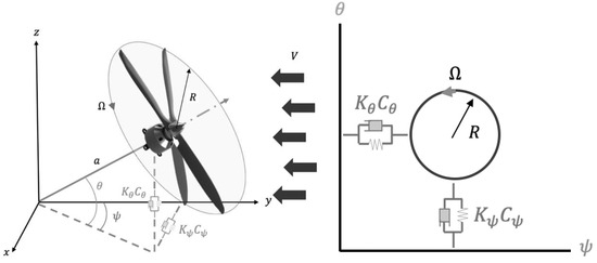
Whirl flutter is a phenomenon caused by an aeroelastic instability, causing oscillations to propagate in manned or unmanned rotor-nacelle type aircraft. Under the conditions where multi-segmented freeplay are present, complex behaviors can dominate these oscillations and can lead to disastrous consequences. This study investigates a rotor-nacelle system with multi-segmented stiffnesses with a freeplay gap to encompass the real-world influences of aircraft. The mathematical aerodynamics model considers a quasi-steady application of strip theory along each blade to outline the external forces being applied. A free-body diagram is then used to incorporate the structural stiffness and damping terms with multi-segmented freeplay considered in the structural stiffness matrix. Multiple structural responses of the defined system are investigated and characterized to determine the influence of varying symmetric and asymmetric multi-segmented stiffnesses with varying gap parameters, including a route to impact investigation. The findings are characterized using phase portraits, Poincaré maps, time histories, and basins of attraction. It is found that under these conditions, the structural influences can lead to aperiodic oscillations with the existence of grazing bifurcations. Furthermore, these results unveil that under certain conditions and high freestream velocities, the sticking phenomenon becomes apparent which is strongly dependent on the strength of the multi-segmented representation, its gap sizes, and its symmetry. Lastly, a route to impact study shows the strong coupled influence between pitch and yaw when asymmetric conditions are applied and the possible presence of grazing-sliding bifurcations. The numerical simulations performed in this study can form a basis for drone designers to create reliable rotor-nacelle systems resistant to whirl flutter caused by freeplay effects. Full article
Show Figures

Figure 1

15 pages, 16300 KiB  
Article
A Novel Technique Based on Machine Learning for Detecting and Segmenting Trees in Very High Resolution Digital Images from Unmanned Aerial Vehicles
by Loukas Kouvaras and George P. Petropoulos
Drones 2024, 8(2), 43; https://doi.org/10.3390/drones8020043 - 1 Feb 2024
Cited by 2 | Viewed by 2606
Abstract
The present study proposes a technique for automated tree crown detection and segmentation in digital images derived from unmanned aerial vehicles (UAVs) using a machine learning (ML) algorithm named Detectron2. The technique, which was developed in the python programming language, receives as input [...] Read more.
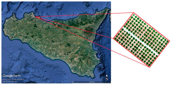
The present study proposes a technique for automated tree crown detection and segmentation in digital images derived from unmanned aerial vehicles (UAVs) using a machine learning (ML) algorithm named Detectron2. The technique, which was developed in the python programming language, receives as input images with object boundary information. After training on sets of data, it is able to set its own object boundaries. In the present study, the algorithm was trained for tree crown detection and segmentation. The test bed consisted of UAV imagery of an agricultural field of tangerine trees in the city of Palermo in Sicily, Italy. The algorithm’s output was the accurate boundary of each tree. The output from the developed algorithm was compared against the results of tree boundary segmentation generated by the Support Vector Machine (SVM) supervised classifier, which has proven to be a very promising object segmentation method. The results from the two methods were compared with the most accurate yet time-consuming method, direct digitalization. For accuracy assessment purposes, the detected area efficiency, skipped area rate, and false area rate were estimated for both methods. The results showed that the Detectron2 algorithm is more efficient in segmenting the relevant data when compared to the SVM model in two out of the three indices. Specifically, the Detectron2 algorithm exhibited a 0.959% and 0.041% fidelity rate on the common detected and skipped area rate, respectively, when compared with the digitalization method. The SVM exhibited 0.902% and 0.097%, respectively. On the other hand, the SVM classification generated better false detected area results, with 0.035% accuracy, compared to the Detectron2 algorithm’s 0.056%. Having an accurate estimation of the tree boundaries from the Detectron2 algorithm, the tree health assessment was evaluated last. For this to happen, three different vegetation indices were produced (NDVI, GLI and VARI). All those indices showed tree health as average. All in all, the results demonstrated the ability of the technique to detect and segment trees from UAV imagery. Full article
Show Figures

Figure 1

24 pages, 414 KiB  
Review
Navigation and Deployment of Solar-Powered Unmanned Aerial Vehicles for Civilian Applications: A Comprehensive Review
by Siyuan Li, Zixuan Fang, Satish C. Verma, Jingwen Wei and Andrey V. Savkin
Drones 2024, 8(2), 42; https://doi.org/10.3390/drones8020042 - 31 Jan 2024
Cited by 3 | Viewed by 3392
Abstract
Unmanned aerial systems and renewable energy are two research areas that have developed rapidly over the last few decades. Solar-powered unmanned aerial vehicles (SUAVs) are likely to become dominant in the near future. They have the advantage of low cost and safe operation [...] Read more.
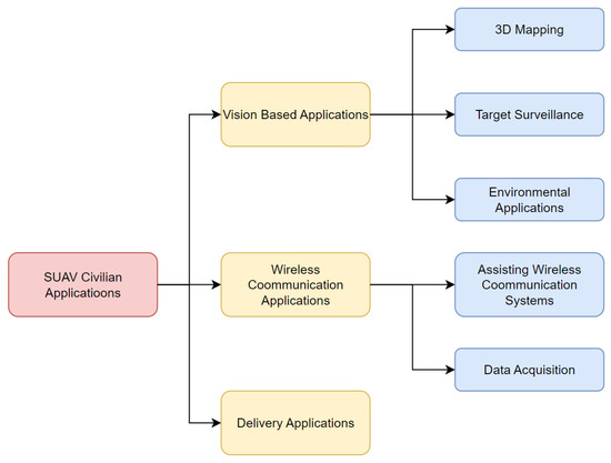
Unmanned aerial systems and renewable energy are two research areas that have developed rapidly over the last few decades. Solar-powered unmanned aerial vehicles (SUAVs) are likely to become dominant in the near future. They have the advantage of low cost and safe operation features that mitigate the barriers to their use in various environments. Developing effective algorithms for navigating and deploying SUAVs is essential for implementing this technology in real-life applications. Effective navigation and deployment algorithms also ensure the safety and efficiency of SUAV operations. This comprehensive review paper summarizes some state-of-the-art SUAV applications and provides an overview of the navigation and deployment algorithms for SUAVs. Some commonly used energy-harvesting models are described as well. Finally, some interesting and promising directions for future SUAV research are suggested. Full article
Show Figures

Figure 1

Back to TopTop