remotesensing-logo

Journal Browser

Journal Browser

Teaching and Learning in Remote Sensing

Editors


E-Mail Website
Guest Editor
Institute for Geoinformation and Surveying, Department of Architecture, Facility Management and Geoinformation, Anhalt University of Applied Sciences, Bauhausstrasse 8 (Building 07), 06846 Dessau, Germany
Interests: multi-sensor remote sensing; hyperspectral remote sensing; thermal remote sensing; soil moisture remote sensing; environmental monitoring; in situ/remote sensing integration; remote sensing higher education
Special Issues, Collections and Topics in MDPI journals

E-Mail Website
Guest Editor
1. Department of Geoinformatics and Remote Sensing, Leipzig University (LU), D-04103 Leipzig, Germany
2. Technical Department, Szent István University, (SZIU), H-1118 Budapest, Hungary
Interests: hyperspectral remote sensing; field spectroscopy; mobile and snapshot imaging spectroscopy; precision farming; agriculture
Special Issues, Collections and Topics in MDPI journals

Topical Collection Information

Dear Colleagues,

Satellite and airborne remote sensing of the Earth’s environment is a comparatively young science characterized by technological innovations in short temporal intervals. For the successful, sustainable, and timely utilization of new and upcoming remote sensing data, individuals require methodological expertise and new skills (e.g., handling hyperspectral observations and full polarimetric SAR data).

Training people in these competences is essential to ensure high quality in the field. Therefore, attention has to be turned to teaching and learning remote sensing in higher education (and even earlier) as an ongoing and scholarly process to address the academic and industrial market requirements. Aside from its fast development, a further didactic challenge is the interdisciplinary character of remote sensing, including, for example, competences from electrical engineering, earth sciences, physics, or biology. While various innovative didactic concepts promoting learning, such as the flipped classroom approach or problem-based learning, have been successfully demonstrated in different fields of engineering education, practice reports in teaching and learning remote sensing are widely missing.

The goal of this Special Issue is to foster and disseminate experiences and findings about what improves the learning and teaching of remote sensing in higher education and in the interdisciplinary context of environmental sciences. The publications within this Special Issue shall support and inspire other educators in the field to successfully design their courses and train the next generation.

Contributions presenting teaching concepts, case studies, and reviews related to remote sensing education are our priority, and may include:

  • Practice reports including reflection and student feedback;
  • E-learning concepts including reflection and student feedback;
  • Scholarship of Teaching and Learning (SoTL) studies; and
  • Educational theories and practices related to remote sensing teaching and learning.

Dr. Marion Pause
Privat. Doz. Dr. habil. Angela Lausch
Dr. habil. András Jung
Guest Editors

Manuscript Submission Information

Manuscripts should be submitted online at www.mdpi.com by registering and logging in to this website. Once you are registered, click here to go to the submission form. Manuscripts can be submitted until the deadline. All submissions that pass pre-check are peer-reviewed. Accepted papers will be published continuously in the journal (as soon as accepted) and will be listed together on the collection website. Research articles, review articles as well as short communications are invited. For planned papers, a title and short abstract (about 100 words) can be sent to the Editorial Office for announcement on this website.

Submitted manuscripts should not have been published previously, nor be under consideration for publication elsewhere (except conference proceedings papers). All manuscripts are thoroughly refereed through a single-blind peer-review process. A guide for authors and other relevant information for submission of manuscripts is available on the Instructions for Authors page. Remote Sensing is an international peer-reviewed open access semimonthly journal published by MDPI.

Please visit the Instructions for Authors page before submitting a manuscript. The Article Processing Charge (APC) for publication in this open access journal is 2700 CHF (Swiss Francs). Submitted papers should be well formatted and use good English. Authors may use MDPI's English editing service prior to publication or during author revisions.

Published Papers (17 papers)

2023

Jump to: 2022, 2021, 2020, 2019

18 pages, 5728 KiB  
Article
SatelliteSkill5—An Augmented Reality Educational Experience Teaching Remote Sensing through the UN Sustainable Development Goals
by Eimear McNerney, Jonathan Faull, Sasha Brown, Lorraine McNerney, Ronan Foley, James Lonergan, Angela Rickard, Zerrin Doganca Kucuk, Avril Behan, Bernard Essel, Isaac Obour Mensah, Yeray Castillo Campo, Helen Cullen, Jack Ffrench, Rachel Abernethy, Patricia Cleary, Aengus Byrne and Conor Cahalane
Remote Sens. 2023, 15(23), 5480; https://doi.org/10.3390/rs15235480 - 23 Nov 2023
Cited by 1 | Viewed by 1626
Abstract
Advances in visualisation techniques provide new ways for us to explore how we introduce complex topics like remote sensing to non-specialist audiences. Taking inspiration from the popularity of augmented reality (AR) apps, a free, mobile digital AR app titled SatelliteSkill5, has been [...] Read more.
Advances in visualisation techniques provide new ways for us to explore how we introduce complex topics like remote sensing to non-specialist audiences. Taking inspiration from the popularity of augmented reality (AR) apps, a free, mobile digital AR app titled SatelliteSkill5, has been developed for both Androids and iPhones in Unity AR. SatelliteSkill5 helps users conceptualise remote sensing (RS) theory and technology by showcasing the potential of datasets such as multispectral images, SAR backscatter, drone orthophotography, and bathymetric LIDAR for tackling real-world challenges, with examples tackling many of the United Nations’ Sustainable Development Goals (SDGs) as the focus. Leveraging tried and tested pedagogic practices such as active learning, game-based learning, and targeting cross-curricular topics, SatelliteSkill5 introduces users to many of the fundamental geospatial data themes identified by the UN as essential for meeting the SDGs, imparting users with a familiarity of concepts such as land cover, elevation, land parcels, bathymetry, and soil. The SatelliteSkill5 app was piloted in 12 Irish schools during 2021 and 2022 and with 861 students ranging from 12 to 18 years old. This research shows that both students and teachers value learning in an easy-to-use AR environment and that SDGs help users to better understand complex remote sensing theory. Full article
Show Figures

Figure 1

2022

Jump to: 2023, 2021, 2020, 2019

23 pages, 3374 KiB  
Article
Five Guiding Principles to Make Jupyter Notebooks Fit for Earth Observation Data Education
by Julia Wagemann, Federico Fierli, Simone Mantovani, Stephan Siemen, Bernhard Seeger and Jörg Bendix
Remote Sens. 2022, 14(14), 3359; https://doi.org/10.3390/rs14143359 - 12 Jul 2022
Cited by 10 | Viewed by 5919
Abstract
There is a growing demand to train Earth Observation (EO) data users in how to access and use existing and upcoming data. A promising tool for data-related training is computational notebooks, which are interactive web applications that combine text, code and computational output. [...] Read more.
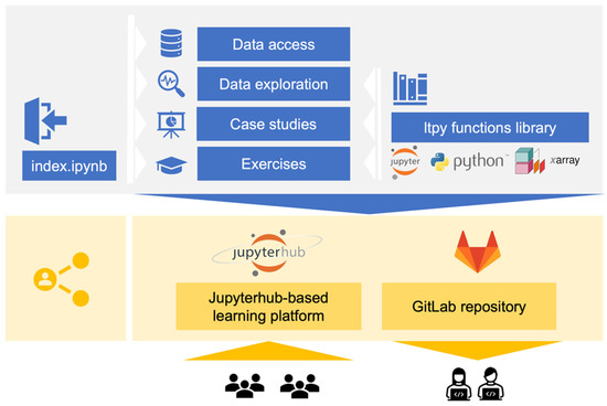
There is a growing demand to train Earth Observation (EO) data users in how to access and use existing and upcoming data. A promising tool for data-related training is computational notebooks, which are interactive web applications that combine text, code and computational output. Here, we present the Learning Tool for Python (LTPy), which is a training course (based on Jupyter notebooks) on atmospheric composition data. LTPy consists of more than 70 notebooks and has taught over 1000 EO data users so far, whose feedback is overall positive. We adapted five guiding principles from different fields (mainly scientific computing and Jupyter notebook research) to make the Jupyter notebooks more educational and reusable. The Jupyter notebooks developed (i) follow the literate programming paradigm by a text/code ratio of 3, (ii) use instructional design elements to improve navigation and user experience, (iii) modularize functions to follow best practices for scientific computing, (iv) leverage the wider Jupyter ecosystem to make content accessible and (v) aim for being reproducible. We see two areas for future developments: first, to collect feedback and evaluate whether the instructional design elements proposed meet their objective; and second, to develop tools that automatize the implementation of best practices. Full article
Show Figures

Figure 1

21 pages, 13146 KiB  
Article
How to Boost Close-Range Remote Sensing Courses Using a Serious Game: Uncover in a Fun Way the Complexity and Transversality of Multi-Domain Field Acquisitions
by Loïca Avanthey and Laurent Beaudoin
Remote Sens. 2022, 14(4), 817; https://doi.org/10.3390/rs14040817 - 9 Feb 2022
Cited by 1 | Viewed by 2151
Abstract
Close-range remote sensing, and more particularly, its acquisition part that is linked to field robotics, is at the crossroads of many scientific and engineering fields. Thus, it takes time for students to acquire the solid foundations needed before practicing on real systems. Therefore, [...] Read more.
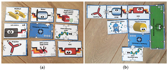
Close-range remote sensing, and more particularly, its acquisition part that is linked to field robotics, is at the crossroads of many scientific and engineering fields. Thus, it takes time for students to acquire the solid foundations needed before practicing on real systems. Therefore, we are interested in a means that allow students without prerequisites to quickly appropriate the fundamentals of this interdisciplinary field. For this, we adapted a haggle game to the close-range remote sensing theme. In this article, we explain the mechanics that serve our educational purposes. We have used it, so far, for four academic years with hundreds of students. The experience was assessed through quality surveys and quizzes to calculate success indicators. The results show that the serious game is well appreciated by the students. It allows them to better structure information and acquire a good global vision of multi-domain acquisition and data processing in close-range remote sensing. The students are also more involved in the rest of the lessons; all of this helps to facilitate their learning of the theoretical parts. Thus, we were able to shorten the time before moving on to real practice by replacing three lesson sessions with one serious game session, with an increase in mastering fundamental skills. The designed serious game can be useful for close-range remote sensing teachers looking for an effective starting lesson. In addition, teachers from other technical fields can draw inspiration from the creation mechanisms described in this article to create their own adapted version. Such a serious game is also a good asset for selecting promising students in a recruitment context. Full article
Show Figures

Figure 1

28 pages, 53843 KiB  
Article
Development of an App and Teaching Concept for Implementation of Hyperspectral Remote Sensing Data into School Lessons Using Augmented Reality
by Claudia Lindner, Andreas Rienow, Karl-Heinz Otto and Carsten Juergens
Remote Sens. 2022, 14(3), 791; https://doi.org/10.3390/rs14030791 - 8 Feb 2022
Cited by 10 | Viewed by 3571
Abstract
For the purpose of expanding STEM (science, technology, engineering, mathematics) education with remote sensing (RS) data and methods, an augmented reality (AR) app was developed in combination with a worksheet and lesson plan. Data from the Hyperspectral Imager for the Coastal Ocean (HICO) [...] Read more.
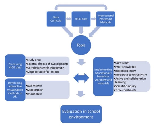
For the purpose of expanding STEM (science, technology, engineering, mathematics) education with remote sensing (RS) data and methods, an augmented reality (AR) app was developed in combination with a worksheet and lesson plan. Data from the Hyperspectral Imager for the Coastal Ocean (HICO) was searched for topics applicable to STEM curricula, which was found in the example of a harmful algal bloom in Lake Erie, USA, in 2011. Spectral shape algorithms were applied to differentiate between less harmful green and more harmful blue algae in the lake. The data was pre-processed to reduce its size significantly without losing too much information and then integrated into an app that was developed in Unity with the Vuforia extension. It was designed to let students browse and understand the raw data in RGB and a tangible hyperspectral cube, as well as to analyze algae maps derived from it. The app runs on Android smartphones with minimized data usage to make it less dependent on school funding and the socioeconomic background of students. Using educational concepts, such as active and collaborative learning, moderate constructivism, and scientific inquiry, the data was integrated into a lesson about environmental problems that was enhanced by the AR app. The app and worksheet were evaluated in two advanced geography courses (n = 36) and found to be complex, but doable and understandable, for the target group of German high school students in their final two school years. Thus, hyperspectral data can be used for STEM lessons using AR technology on students’ smartphones with several limitations both in the technology used and gainable knowledge. Full article
Show Figures

Figure 1

2021

Jump to: 2023, 2022, 2020, 2019

18 pages, 4563 KiB  
Article
Creating and Testing Explainer Videos for Earth Observation
by Henryk Hodam, Andreas Rienow and Carsten Juergens
Remote Sens. 2021, 13(20), 4178; https://doi.org/10.3390/rs13204178 - 19 Oct 2021
Cited by 2 | Viewed by 2584
Abstract
Learning videos can be concise learning packages that offer a wide range of possibilities when it comes to present topics in an up-to-date way and disseminating them in a variety of learning environments. Videos are already a primary source of information in our [...] Read more.
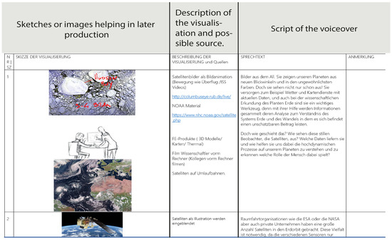
Learning videos can be concise learning packages that offer a wide range of possibilities when it comes to present topics in an up-to-date way and disseminating them in a variety of learning environments. Videos are already a primary source of information in our society; however, few examples convey earth observation topics. Over recent decades, numerous studies established guidelines on how educational videos can be successful. This paper presents a workflow to use these guidelines in the creation of learning videos covering the basic concepts of earth observation. The target groups for these videos are secondary students as well as anyone interested in learning about earth observation. Two of those videos, one on earth observation in general and one on the basics of the electromagnetic spectrum, were used in this research. To test whether or not the workflow leads to effective learning videos and to compare them to traditional text and illustration material derived from those videos, a pre-test/post-test study was undertaken focusing on German pupils in their final year at secondary school as well as first semester university students. Due to the special circumstances faced during the COVID-19 crisis, this experimental setup used a combination of online questionnaire tools and a web environment. The results show that both methods were effective resources that led to a significant increase in knowledge—raising the test results by 21% for the video and 13% for the text and illustration group. Full article
Show Figures

Figure 1

15 pages, 2618 KiB  
Case Report
The Making of a Joint E-Learning Platform for Remote Sensing Education: Experiences and Lessons Learned
by Thomas Bauer, Markus Immitzer, Reinfried Mansberger, Francesco Vuolo, Béla Márkus, Małgorzata Verőné Wojtaszek, Lóránt Földváry, Aneta Szablowska-Midor, Jacek Kozak, Ivan Oliveira, Arno van Lieshout, Zoltán Vekerdy, Sarawut Ninsawat and Chitrini Mozumder
Remote Sens. 2021, 13(9), 1718; https://doi.org/10.3390/rs13091718 - 29 Apr 2021
Cited by 6 | Viewed by 3602
Abstract
E-learning is widely used in academic education, and currently, the COVID-19 pandemic is increasing the demand for e-learning resources. This report describes the results achieved and the experiences gained in the Erasmus+ CBHE (Capacity Building in Higher Education) project “Innovation on Remote Sensing [...] Read more.
E-learning is widely used in academic education, and currently, the COVID-19 pandemic is increasing the demand for e-learning resources. This report describes the results achieved and the experiences gained in the Erasmus+ CBHE (Capacity Building in Higher Education) project “Innovation on Remote Sensing Education and Learning (IRSEL)”. European and Asian universities created an innovative open source e-learning platform in the field of remote sensing. Twenty modules tailored to remote sensing study programs at the four Asian partner universities were developed. Principles of remote sensing as well as specific thematic applications are part of the modules, and a knowledge pool of e-learning teaching and learning materials was created. The focus was given to case studies covering a broad range of applications. Piloting with students gave evidence about the usefulness and quality of the developed modules. In particular, teachers and students who tested the modules appreciated the balance of theory and practice. Currently, the modules are being integrated into the curricula of the participating Asian universities. The content will be available to a broader public. Full article
Show Figures

Graphical abstract

17 pages, 1993 KiB  
Article
Earth Observation as a Facilitator of Climate Change Education in Schools: The Teachers’ Perspectives
by Panagiota Asimakopoulou, Panagiotis Nastos, Emmanuel Vassilakis, Maria Hatzaki and Assimina Antonarakou
Remote Sens. 2021, 13(8), 1587; https://doi.org/10.3390/rs13081587 - 20 Apr 2021
Cited by 8 | Viewed by 4046
Abstract
Climate change education (CCE) fosters the skills and behavioral patterns of students in regards to climate-related challenges and risks. Despite its importance, the integration of CCE in schools is challenging due to the interdisciplinary nature of climate science and the obstacles and demands [...] Read more.
Climate change education (CCE) fosters the skills and behavioral patterns of students in regards to climate-related challenges and risks. Despite its importance, the integration of CCE in schools is challenging due to the interdisciplinary nature of climate science and the obstacles and demands of everyday school reality. Here, we examine the case of satellite Remote Sensing (RS) for Earth Observation (EO) as an innovative tool for facilitating CCE. We focus on Greece, a country that, despite being a hot spot for climate change, shows a low level of CCE integration in schools and awareness for EO-based educational resources. Based on interviews with in-service teachers, our research reveals the following: (a) there is a high interest in how satellites depict environmental phenomena; (b) EO is considered an efficient vehicle for promoting CCE in schools because it illustrates climate change impacts most effectively; (c) local natural disasters, such as intense forest fires and floods, are more familiar to students and, thus, preferable for teaching when compared to global issues, such as the greenhouse effect and sea level rise; and (d) educators are in favor of short, hands-on, EO-based activities (also known as “activity-shots”), as the most useful material format for integrating climate change topics in their everyday teaching practice. Full article
Show Figures

Figure 1

19 pages, 8548 KiB  
Article
Design of a Didactical Activity for the Analysis of Uncertainties in Thermography through the Use of Robust Statistics as Teacher-Oriented Approach
by Pablo Rodríguez-Gonzálvez and Manuel Rodríguez-Martín
Remote Sens. 2021, 13(3), 402; https://doi.org/10.3390/rs13030402 - 24 Jan 2021
Cited by 5 | Viewed by 2242
Abstract
The thermography as a methodology to quantitative data acquisition is not usually addressed in the degrees of university programs. The present manuscript proposes a novel approach for the acquisition of advanced competences in engineering courses associated with the use of thermographic images via [...] Read more.
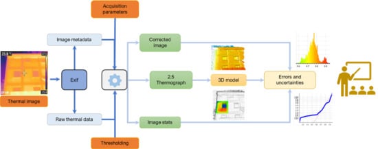
The thermography as a methodology to quantitative data acquisition is not usually addressed in the degrees of university programs. The present manuscript proposes a novel approach for the acquisition of advanced competences in engineering courses associated with the use of thermographic images via free/open-source software solutions. This strategy is established from a research based on the statistical and three-dimensional visualization techniques over thermographic imagery to improve the interpretation and comprehension of the different sources of error affecting the measurements and, thereby, the conclusions and analysis arising from them. The novelty is focused on the detection of non-normalities in thermographic images, which is illustrates in the experimental section. Additionally, the specific workflow for the generation of learning material related with this aim is raised for asynchronous and e-learning programs. These virtual materials can be easily deployed in an institutional learning management system, allowing the students to work with the models by means of free/open-source solutions easily. Subsequently, the present approach will give new tools to improve the application of professional techniques, will improve the students’ critical sense to know how to interpret the uncertainties in thermography using a single thermographic image, therefore they will be better prepared to face future challenges with more critical thinking. Full article
Show Figures

Graphical abstract

2020

Jump to: 2023, 2022, 2021, 2019

11 pages, 1570 KiB  
Letter
Building Skills for the Future: Teaching High School Students to Utilize Remote Sensing of Wildfires
by Stefania Amici and Marek Tesar
Remote Sens. 2020, 12(21), 3635; https://doi.org/10.3390/rs12213635 - 5 Nov 2020
Cited by 6 | Viewed by 2721
Abstract
A substantial proportion of Italian students are unaware of the connection between what they learn at school and their work opportunities .This proportion would most likely increase if data were collected today, given the generation of a broad range of new jobs that [...] Read more.
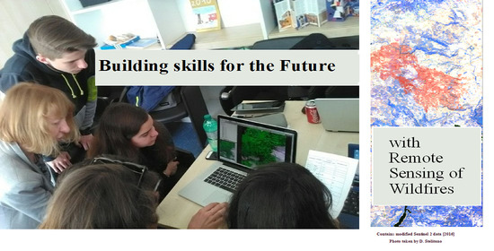
A substantial proportion of Italian students are unaware of the connection between what they learn at school and their work opportunities .This proportion would most likely increase if data were collected today, given the generation of a broad range of new jobs that has arisen due to advancements in technology. This gap between students’ understanding of what they learn at school and its application to the broader world—the society, the economy and the political sphere—suggests there needs to be a rethinking of how teaching and learning at school is conceived and positioned. To help students to approach ongoing social and economic transformations, the Italian Educational Ministry (MIUR) has endorsed a school–work interchange program which, aligned with the principle of open schools, aims to provide students with work experience. It is within the scope of this initiative that we have tested high school students with remote sensing (RS) from space projects. The experience-based approach aimed to verify students’ openness to the use of satellite data as a means to learn new interdisciplinary skills, to familiarize themselves with methodological knowledge and, finally, to inspire them when choosing a university or areas of future work. We engaged three cohorts, from 2017, 2018 and 2019, for a total of 40 h each year, including contact and non-contact time. The framework of each project was the same for the three cohorts and focused on the observation of Earth from space with a specific focus on wildfires. However, the initiative went beyond this, with diverse activities and tasks being assigned. This paper reports the pedagogical methods utilized with the three cohorts and how these methods were transformed and adapted in order to improve and enhance the learning outcomes. It also explores the outcomes for the students, teachers and family members, with respect to their learning and general appreciation. Full article
Show Figures

Graphical abstract

22 pages, 10976 KiB  
Article
Bringing Earth Observation to Classrooms—The Importance of Out-of-School Learning Places and E-Learning
by Lisa Dannwolf, Tobias Matusch, Johannes Keller, Ronja Redlich and Alexander Siegmund
Remote Sens. 2020, 12(19), 3117; https://doi.org/10.3390/rs12193117 - 23 Sep 2020
Cited by 8 | Viewed by 4365
Abstract
Viewing the Earth from above has fascinated people at least since the Apollo mission in the 1960s. Today, satellite images have made their way into the news and media, but the potential of using satellite images in the classroom has not yet been [...] Read more.
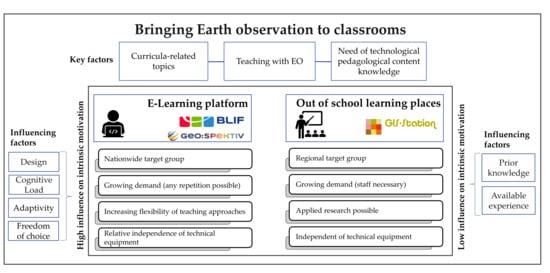
Viewing the Earth from above has fascinated people at least since the Apollo mission in the 1960s. Today, satellite images have made their way into the news and media, but the potential of using satellite images in the classroom has not yet been exhausted. Teachers often lack the technical knowledge of Earth observation (EO) or the technical requirements in schools. The Geo:spektiv e-learning platform used provides the opportunity to integrate EO into curricula as well as current environmental- and space-relevant topics. This study analyses the driving forces that determine the motivation of students and which factors contribute to the success of an e-learning platform. The basis for this study is a Geo:spektiv module about the endangered rainforest, established at an out-of-school learning place and designed for students in secondary education. A survey of 281 students on their motivation and learning behavior showed, that in addition to the topic and level of difficulty tailored to the students’ needs, the design of the modules, simple navigation, and the use of multimedia content are vital. Despite the small sampling size and restricted geographical location of sample selection, the results of this study can contribute to better integration of digital geo-media in school lessons. Full article
Show Figures

Graphical abstract

16 pages, 3028 KiB  
Letter
Building an Online Learning Module for Satellite Remote Sensing Applications in Hydrologic Science
by Viviana Maggioni, Manuela Girotto, Emad Habib and Melissa A. Gallagher
Remote Sens. 2020, 12(18), 3009; https://doi.org/10.3390/rs12183009 - 16 Sep 2020
Cited by 14 | Viewed by 4223
Abstract
This article presents an online teaching tool that introduces students to basic concepts of remote sensing and its applications in hydrology. The learning module is intended for junior/senior undergraduate students or junior graduate students with no (or little) prior experience in remote sensing, [...] Read more.
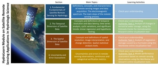
This article presents an online teaching tool that introduces students to basic concepts of remote sensing and its applications in hydrology. The learning module is intended for junior/senior undergraduate students or junior graduate students with no (or little) prior experience in remote sensing, but with some basic background of environmental science, hydrology, statistics, and programming. This e-learning environment offers background content on the fundamentals of remote sensing, but also integrates a set of existing online tools for visualization and analysis of satellite observations. Specifically, students are introduced to a variety of satellite products and techniques that can be used to monitor and analyze changes in the hydrological cycle. At completion of the module, students are able to visualize remote sensing data (both in terms of time series and spatial maps), detect temporal trends, interpret satellite images, and assess errors and uncertainties in a remote sensing product. Students are given the opportunity to check their understanding as they progress through the module and also tackle complex real-life problems using remote sensing observations that professionals and scientists commonly use in practice. The learning tool is implemented in HydroLearn, an open-source, online platform for instructors to find and share learning modules and collaborate on developing teaching resources in hydrology and water resources. Full article
Show Figures

Graphical abstract

14 pages, 2070 KiB  
Letter
Interdisciplinary Teaching Using Satellite Images as a Way to Introduce Remote Sensing in Secondary School
by Daniel Dziob, Michał Krupiński, Edyta Woźniak and Ryszard Gabryszewski
Remote Sens. 2020, 12(18), 2868; https://doi.org/10.3390/rs12182868 - 4 Sep 2020
Cited by 12 | Viewed by 5374
Abstract
This article aims to meet two needs: (i) the need for skilled workers and students in the area of remote sensing and (ii) the need to make school science interesting for students. This article addresses both needs by proposing a project for high [...] Read more.
This article aims to meet two needs: (i) the need for skilled workers and students in the area of remote sensing and (ii) the need to make school science interesting for students. This article addresses both needs by proposing a project for high school students entitled “the Colors of Earth”. The main aim for students was to distinguish between different types of land cover via the creation of various false color band compositions from the satellite Sentinel-2. Achieving this goal requires knowledge from various subjects and enables their practical application via work performed using real data. The project was presented to 39 high-school teachers and 184 high-school students (K-9 and K-10) in the summer semester of the 2019/2020 school year, and their opinions about the project were collected. Overall, both students and teachers judged the project to be interesting, worth introducing to the school, and capable of influencing student opinions of science. In addition, introducing remote sensing elements during pre-university education can help meet the demands for students and workers to study Earth observation. Full article
Show Figures

Figure 1

14 pages, 1679 KiB  
Letter
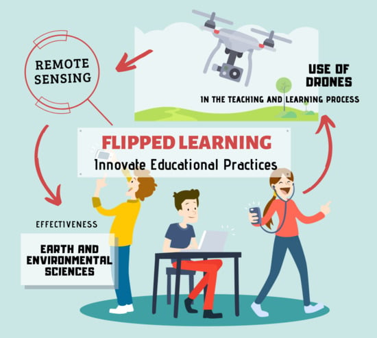
Effectiveness of Innovate Educational Practices with Flipped Learning and Remote Sensing in Earth and Environmental Sciences—An Exploratory Case Study
by Juan Antonio López Núñez, Jesús López Belmonte, Antonio José Moreno Guerrero and Santiago Pozo Sánchez
Remote Sens. 2020, 12(5), 897; https://doi.org/10.3390/rs12050897 - 10 Mar 2020
Cited by 34 | Viewed by 6253
Abstract
The rapid advancements in the technological field, especially in the field of education, have led to the incorporation of remote sensing in learning spaces. This innovation requires active and effective teaching methods, among which is flipped learning. The objective of this research was [...] Read more.
The rapid advancements in the technological field, especially in the field of education, have led to the incorporation of remote sensing in learning spaces. This innovation requires active and effective teaching methods, among which is flipped learning. The objective of this research was to analyze the effectiveness of flipped learning on the traditional-expository methodology in the second year of high school. The research is part of a quantitative methodology based on a quasi-experimental design of descriptive and correlational type. Data collection was carried out through an ad hoc questionnaire applied in a sample of 59 students. The Student’s t-test was applied for independent samples, differentiating the means given between the experimental group and the control group. The results show that there was a better assessment of the teaching method through flipped learning than the traditional teaching method in all the variables analyzed, except in the academic results, where the difference was minimal. It is concluded that flipped learning provides improvements in instructional processes in high school students who have used remote sensing in training practices. Therefore, the combination of flipped learning and remote sensing is considered effective for the work of contents related to environmental sciences in said educational level. Full article
Show Figures

Graphical abstract

12 pages, 986 KiB  
Letter
Advancing Learning Assignments in Remote Sensing of the Environment Through Simulation Games
by Martin Gerner and Marion Pause
Remote Sens. 2020, 12(4), 735; https://doi.org/10.3390/rs12040735 - 22 Feb 2020
Cited by 6 | Viewed by 4071
Abstract
Environmental remote sensing has faced increasing satellite data availability, advanced algorithms for thematic analysis, and novel concepts of ground truth. For that reason, contents and concepts of learning and teaching remote sensing are constantly evolving. This eventually leads to the intuition of methodologically [...] Read more.
Environmental remote sensing has faced increasing satellite data availability, advanced algorithms for thematic analysis, and novel concepts of ground truth. For that reason, contents and concepts of learning and teaching remote sensing are constantly evolving. This eventually leads to the intuition of methodologically linking academic learning assignments with case-related scopes of application. In order to render case-related learning possible, smart teaching and interactive learning contexts are appreciated and required for remote sensing. That is due to the fact that those contexts are considered promising to trigger and gradually foster students’ comprehensive interdisciplinary thinking. To this end, the following contribution introduces the case-related concept of applying simulation games as a promising didactic format in teaching/learning assignments of remote sensing. As to methodology, participating students have been invited to take on individual roles bound to technology-related profiles (e.g., satellite-mission planning, irrigation, etc.) Based on the scenario, stakeholder teams have been requested to elaborate, analyze and negotiate viable solutions for soil moisture monitoring in a defined context. Collaboration has been encouraged by providing the protected, specifically designed remoSSoil-incubator environment. This letter-type paper aims to introduce the simulation game technique in the context of remote sensing as a type of scholarly teaching; it evaluates learning outcomes by adopting certain techniques of scholarship of teaching and learning (SoTL); and it provides food for thought of replicating, adapting and enhancing simulation games as an innovative, disruptive next-generation learning environment in remote sensing. Full article
Show Figures

Figure 1

19 pages, 15485 KiB  
Article
Bringing Earth Observation to Schools with Digital Integrated Learning Environments
by Henryk Hodam, Andreas Rienow and Carsten Jürgens
Remote Sens. 2020, 12(3), 345; https://doi.org/10.3390/rs12030345 - 21 Jan 2020
Cited by 17 | Viewed by 4194
Abstract
The digital integrated learning environments (ILEs) for earth observation described in this article are bringing the complex topic of earth observation into classrooms. They are intended to give pupils with no prior experience in remote sensing the opportunity to solve tasks with earth [...] Read more.
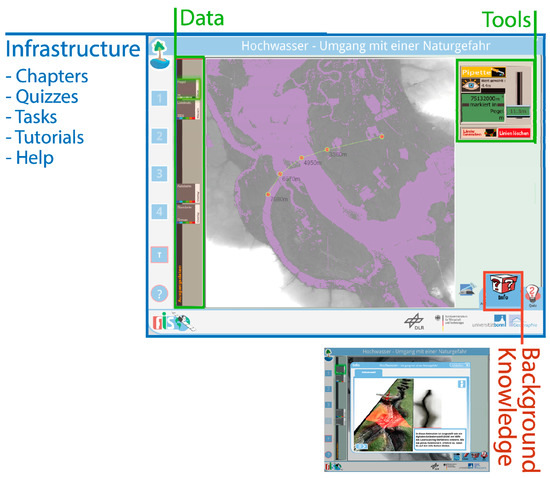
The digital integrated learning environments (ILEs) for earth observation described in this article are bringing the complex topic of earth observation into classrooms. They are intended to give pupils with no prior experience in remote sensing the opportunity to solve tasks with earth observation data by using the same means that professionals have at hand. These learning environments integrate remote sensing tools and background knowledge in a comprehensive e-learning environment. They are tailored for use in schools, whereby the curriculum typically does not include earth observation, teachers are generally not familiar with its concepts, and the technical infrastructure is still not quite ready for digital teaching resources. To make the learning environments applicable, the special demands and obstacles presented by a school environment have to be considered. These obstacles are used to derive the requirements for the use of satellite data in school classes and create classroom resources in terms of technology, didactics, and e-learning. The concept itself was developed ten years ago, and since, then multiple applications have been created and used in classes. Data from an online questionnaire focuses on the specific qualities of the learning modules, enabling us to assess whether the concept works, and where there is need for improvement. The results show that the learning environments are being used, and that they continue to open the minds of pupils and teachers alike to a new perspective on the earth. Full article
Show Figures

Figure 1

2019

Jump to: 2023, 2022, 2021, 2020

18 pages, 7757 KiB  
Article
An Innovative Virtual Simulation Teaching Platform on Digital Mapping with Unmanned Aerial Vehicle for Remote Sensing Education
by Xiaoxing He, Xianghong Hua, Jean-Philippe Montillet, Kegen Yu, Jingui Zou, Dong Xiang, Huiping Zhu, Di Zhang, Zhengkai Huang and Bufan Zhao
Remote Sens. 2019, 11(24), 2993; https://doi.org/10.3390/rs11242993 - 12 Dec 2019
Cited by 21 | Viewed by 4869
Abstract
This work mainly discusses an innovative teaching platform on Unmanned Aerial Vehicle digital mapping for Remote Sensing (RS) education at Wuhan University, underlining the fast development of RS technology. Firstly, we introduce and discuss the future development of the Virtual Simulation Experiment Teaching [...] Read more.
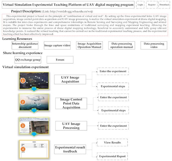
This work mainly discusses an innovative teaching platform on Unmanned Aerial Vehicle digital mapping for Remote Sensing (RS) education at Wuhan University, underlining the fast development of RS technology. Firstly, we introduce and discuss the future development of the Virtual Simulation Experiment Teaching Platform for Unmanned Aerial Vehicle (VSETP-UAV). It includes specific topics such as the Systems and function Design, teaching and learning strategies, and experimental methods. This study shows that VSETP-UAV expands the usual content and training methods related to RS education, and creates a good synergy between teaching and research. The results also show that the VSETP-UAV platform is of high teaching quality producing excellent engineers, with high international standards and innovative skills in the RS field. In particular, it develops students’ practical skills with technical manipulations of dedicated hardware and software equipment (e.g., UAV) in order to assimilate quickly this particular topic. Therefore, students report that this platform is more accessible from an educational point-of-view than theoretical programs, with a quick way of learning basic concepts of RS. Finally, the proposed VSETP-UAV platform achieves a high social influence, expanding the practical content and training methods of UAV based experiments, and providing a platform for producing high-quality national talents with internationally recognized topics related to emerging engineering education. Full article
Show Figures

Graphical abstract

15 pages, 4993 KiB  
Article
Project-Based Learning Applied to Unmanned Aerial Systems and Remote Sensing
by Francisco Javier Mesas-Carrascosa, Fernando Pérez Porras, Paula Triviño-Tarradas, Jose Emilio Meroño de Larriva and Alfonso García-Ferrer
Remote Sens. 2019, 11(20), 2413; https://doi.org/10.3390/rs11202413 - 17 Oct 2019
Cited by 16 | Viewed by 4522
Abstract
The development of unmanned aerial vehicle (UAV) technology and the miniaturization of sensors have changed the way remote sensing (RS) is used, popularizing this geoscientific discipline in other fields, such as precision agriculture. This makes it necessary to implement the use of these [...] Read more.
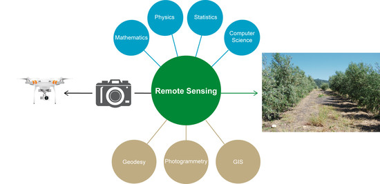
The development of unmanned aerial vehicle (UAV) technology and the miniaturization of sensors have changed the way remote sensing (RS) is used, popularizing this geoscientific discipline in other fields, such as precision agriculture. This makes it necessary to implement the use of these technologies in teaching RS alongside the classical platforms (satellite and manned aircraft). This manuscript describes how The Higher Technical School of Agricultural Engineering at the University of Córdoba (Spain) has introduced UAV RS into the academic program by way of project-based learning (PBL). It also presents the basic characteristics of PBL, the design of the subject, the description of the teacher-guided and self-directed activities, as well as the degree of student satisfaction. The teaching and learning objectives of the subject are to learn how to determine the vigor, temperature, and water stress of a crop through the use of RGB, multispectral, and thermographic sensors onboard a UAV platform. From the onset, students are motivated, actively participate in the tasks related to the realization of UAV flights, and subsequent processing and analysis of the registered images. Students report that PBL is more engaging and allows them to develop a better understanding of RS. Full article
Show Figures

Graphical abstract

Back to TopTop