sustainability-logo

Journal Browser

Journal Browser

Modeling and Simulations for Sustainable Water Environments

A topical collection in Sustainability (ISSN 2071-1050). This collection belongs to the section "Environmental Sustainability and Applications".

Viewed by 29147

Editors


E-Mail Website
Collection Editor
Department of Civil and Environmental Engineering, Konkuk University, Seoul 05029, Republic of Korea
Interests: urban hydrology; urban green infrastructure; urban water availability; urban stormwater management; water quality modeling
Special Issues, Collections and Topics in MDPI journals

E-Mail Website
Collection Editor
Prairie Research Institute, Illinois State Water Survey (ISWS), University of Illinois, Urbana, IL 61801, USA
Interests: stochastic hydrology; hydroclimatology; statistical hydrology; data mining; riverine nutrients; precipitation frequency; flood frequency; climate change
Special Issues, Collections and Topics in MDPI journals

E-Mail Website
Collection Editor
Department of Civil Engineering, Kyonggi University, Suwon-si 16227, Republic of Korea
Interests: hydrology; environmental engineering; hydrological modeling; spatial–temporal analysis; hydro-meteorology; risk analysis; climate change impacts; statistical analysis
Special Issues, Collections and Topics in MDPI journals

Topical Collection Information

Dear Colleagues,

It is with great pleasure that we ask you to share your novel research results in the field of modeling and simulation, including hydrology, hydraulics, and water quality, and ecology in a broad sense, to the Topical Collection “Modeling and Simulations for Sustainable Water Environments” of the journal Sustainability by MDPI. Water availability, hydroclimate variables, water pollution, and ecological impairment are major environmental threats affecting the status of water environment and the human society within them. In addition, climate uncertainty adds complexity to work in sustainable management planning to deal with the above water issues. Various water and environmental models are valuable tools in finding ways to solve environmental problems and mitigate the impact of land use, future climate, and socioeconomic changes on water and environment. Particularly, in the past decade, monitoring that have become increasingly available to improve models in representing actual performance/prediction processes, and land and water management practices, towards an overall improvement of future planning and management of water related environments. This Topical Collection of Sustainability is envisioned to showcase the state-of-the-art in the adaptation and use of observed data for hydrological, hydraulic, water quality, and ecological models at different scales and climatic regions and their application. We hope that new data/methods/models will help us to highlight recent progress in tackling real water environment problems and to outline possible issues that need more focused research.

Prof. Dr. Daeryong Park
Prof. Dr. Momcilo Markus
Prof. Dr. Myoung-Jin Um
Collection Editors

Manuscript Submission Information

Manuscripts should be submitted online at www.mdpi.com by registering and logging in to this website. Once you are registered, click here to go to the submission form. Manuscripts can be submitted until the deadline. All submissions that pass pre-check are peer-reviewed. Accepted papers will be published continuously in the journal (as soon as accepted) and will be listed together on the collection website. Research articles, review articles as well as short communications are invited. For planned papers, a title and short abstract (about 100 words) can be sent to the Editorial Office for announcement on this website.

Submitted manuscripts should not have been published previously, nor be under consideration for publication elsewhere (except conference proceedings papers). All manuscripts are thoroughly refereed through a single-blind peer-review process. A guide for authors and other relevant information for submission of manuscripts is available on the Instructions for Authors page. Sustainability is an international peer-reviewed open access semimonthly journal published by MDPI.

Please visit the Instructions for Authors page before submitting a manuscript. The Article Processing Charge (APC) for publication in this open access journal is 2400 CHF (Swiss Francs). Submitted papers should be well formatted and use good English. Authors may use MDPI's English editing service prior to publication or during author revisions.

Keywords

  • Hydrological/hydraulic/water quality/ecologic modeling
  • Performance modeling, calibration, simulation
  • Data analysis/data assimilation
  • Statistical analysis and modeling
  • Climate change effects
  • Extreme flood and droughts
  • Stormwater

Published Papers (9 papers)

2023

Jump to: 2021, 2020

14 pages, 3587 KiB  
Article
Analysis of Bed Sorting Methods for One Dimensional Sediment Transport Model
by Jeongmin Lee and Jungkyu Ahn
Sustainability 2023, 15(3), 2269; https://doi.org/10.3390/su15032269 - 26 Jan 2023
Cited by 5 | Viewed by 1890
Abstract
Proper estimation of sediment movement is very critical for the management of alluvial rivers. Computing the sediment transport with single particle size is possible. However, particles on the river bed and in transport have a size distribution. It is very important to estimate [...] Read more.
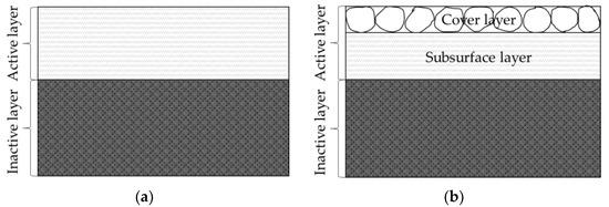
Proper estimation of sediment movement is very critical for the management of alluvial rivers. Computing the sediment transport with single particle size is possible. However, particles on the river bed and in transport have a size distribution. It is very important to estimate bed material size change, such as bed armoring, in case of scour. In this study, the applicability of the bed sorting method, which is available with HEC-RAS, was analyzed. Bed sorting methods divide the bed into two or three layers. Numerical simulations were conducted in the Geum River, Korea. The performance of the simulation with respect to bed sorting methods was evaluated by considering the temporal change of bed material size during the scour and armoring process. Three layer methods are not applicable for a natural river and had oscillatory temporal bed material size variation. The two layer method has stable temporal bed material size changes and predicts the armoring of the bed properly even with limited field data. Consequently, the active layer method is reliable for natural rivers to simulate the bed material size change while applications of three layer methods require sufficient investigation. Full article
Show Figures

Figure 1

2021

Jump to: 2023, 2020

20 pages, 7418 KiB  
Article
High-Resolution Hydrological-Hydraulic Modeling of Urban Floods Using InfoWorks ICM
by Lariyah Mohd Sidek, Aminah Shakirah Jaafar, Wan Hazdy Azad Wan Abdul Majid, Hidayah Basri, Mohammad Marufuzzaman, Muzad Mohd Fared and Wei Chek Moon
Sustainability 2021, 13(18), 10259; https://doi.org/10.3390/su131810259 - 14 Sep 2021
Cited by 48 | Viewed by 5421
Abstract
Malaysia, being a tropical country located near the equatorial doldrums, experiences the annual occurrence of flood hazards due to monsoon rainfalls and urban development. In recent years, environmental policies in the country have shifted towards sustainable flood risk management. As part of the [...] Read more.
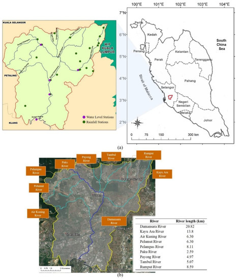
Malaysia, being a tropical country located near the equatorial doldrums, experiences the annual occurrence of flood hazards due to monsoon rainfalls and urban development. In recent years, environmental policies in the country have shifted towards sustainable flood risk management. As part of the development of flood forecasting and warning systems, this study presented the urban flood simulation using InfoWorks ICM hydrological−hydraulic modeling of the Damansara catchment as a case study. The response of catchments to the rainfall was modeled using the Probability Distributed Moisture (PDM) model due to its capability for large catchments with long-term runoff prediction. The interferometric synthetic aperture radar (IFSAR) technique was used to obtain high-resolution digital terrain model (DTM) data. The calibrated and validated model was first applied to investigate the effectiveness of the existing regional ponds on flood mitigation. For a 100-year flood, the extent of flooded areas decreased from 12.41 km2 to 3.61 km2 as a result of 64-ha ponds in the catchment, which is equivalent to a 71% reduction. The flood hazard maps were then generated based on several average recurrence intervals (ARIs) and uniform rainfall depths, and the results showed that both parameters had significant influences on the magnitude of flooding in terms of flood depth and extent. These findings are important for understanding urban flood vulnerability and resilience, which could help in sustainable management planning to deal with urban flooding issues. Full article
Show Figures

Figure 1

18 pages, 486 KiB  
Article
Multimetric Index to Evaluate Water Quality in Lagoons: A Biological and Geomorphological Approach
by Frank Aangel Hernández-Mira, José Luis Rosas-Acevedo, Maximino Reyes-Umaña, Juan Violante-González, José María Sigarreta-Almira and Nodari Vakhania
Sustainability 2021, 13(9), 4631; https://doi.org/10.3390/su13094631 - 21 Apr 2021
Cited by 2 | Viewed by 2147
Abstract
In recent years, Multimetric Indices (MMIs) have received a lot of attention thanks to their ability to develop integrative evaluations of water quality, particularly in lagoons. In this article, we propose a new MMI for determining the water quality in lagoons. The proposed [...] Read more.
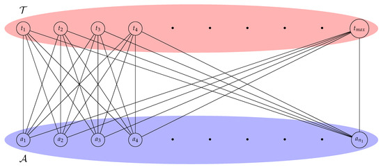
In recent years, Multimetric Indices (MMIs) have received a lot of attention thanks to their ability to develop integrative evaluations of water quality, particularly in lagoons. In this article, we propose a new MMI for determining the water quality in lagoons. The proposed index is composed of biotic and abiotic indicators, in particular macroinvertebrates, macrophytes and morphological indicators. The proposed index is based on a geometric representation of a phenomenon associated with an ecological system, the ecosystem elements are mapped as vertices of a network and the relationship between them is represented by the corresponding edges. We classify the status of water bodies, from very low to very high using the ecological quality ratio. We compare our index with different different indices that measure water quality, such as General Biotic Index (JP(G)), Macrophyte Index for River (MIR) and Shannon diversity index (H’) and validate our index with Pearson’s correlation coefficient. A strong correlation with the JP(G) and MIR indices (R2 = 0.8605 and R2=0.7661, respectively) is obtained. Although the proposed index is composed of other indices, the independence of the proposed index with respect to its component indices is proven and the structure of the geometric model associated to the proposed network is studied. A close relationship between the measure called medium articulation and the geometric model associated with the proposed index is highlighted, which allows to determine the missing relationships in the network using structural analysis. The proposed index presents a more comprehensive measure than most indices currently used and has the advantage in the scalability, since other existing indicators can be integrated into our model. Full article
Show Figures

Figure 1

17 pages, 6482 KiB  
Article
Modeling Surface Water Quality Using the Adaptive Neuro-Fuzzy Inference System Aided by Input Optimization
by Muhammad Izhar Shah, Taher Abunama, Muhammad Faisal Javed, Faizal Bux, Ali Aldrees, Muhammad Atiq Ur Rehman Tariq and Amir Mosavi
Sustainability 2021, 13(8), 4576; https://doi.org/10.3390/su13084576 - 20 Apr 2021
Cited by 33 | Viewed by 3477
Abstract
Modeling surface water quality using soft computing techniques is essential for the effective management of scarce water resources and environmental protection. The development of accurate predictive models with significant input parameters and inconsistent datasets is still a challenge. Therefore, further research is needed [...] Read more.
Modeling surface water quality using soft computing techniques is essential for the effective management of scarce water resources and environmental protection. The development of accurate predictive models with significant input parameters and inconsistent datasets is still a challenge. Therefore, further research is needed to improve the performance of the predictive models. This study presents a methodology for dataset pre-processing and input optimization for reducing the modeling complexity. The objective of this study was achieved by employing a two-sided detection approach for outlier removal and an exhaustive search method for selecting essential modeling inputs. Thereafter, the adaptive neuro-fuzzy inference system (ANFIS) was applied for modeling electrical conductivity (EC) and total dissolved solids (TDS) in the upper Indus River. A larger dataset of a 30-year historical period, measured monthly, was utilized in the modeling process. The prediction capacity of the developed models was estimated by statistical assessment indicators. Moreover, the 10-fold cross-validation method was carried out to address the modeling overfitting issue. The results of the input optimization indicate that Ca2+, Na+, and Cl are the most relevant inputs to be used for EC. Meanwhile, Mg2+, HCO3, and SO42− were selected to model TDS levels. The optimum ANFIS models for the EC and TDS data showed R values of 0.91 and 0.92, and the root mean squared error (RMSE) results of 30.6 µS/cm and 16.7 ppm, respectively. The optimum ANFIS structure comprises a hybrid training algorithm with 27 fuzzy rules of triangular fuzzy membership functions for EC and a Gaussian curve for TDS modeling, respectively. Evidently, the outcome of the present study reveals that the ANFIS modeling, aided with data pre-processing and input optimization, is a suitable technique for simulating the quality of surface water. It could be an effective approach in minimizing modeling complexity and elaborating proper management and mitigation measures. Full article
Show Figures

Figure 1

16 pages, 1320 KiB  
Article
Seamless Integration of Rainfall Spatial Variability and a Conceptual Hydrological Model
by Yan Zhou, Zhongmin Liang, Binquan Li, Yixin Huang, Kai Wang and Yiming Hu
Sustainability 2021, 13(6), 3588; https://doi.org/10.3390/su13063588 - 23 Mar 2021
Cited by 5 | Viewed by 2887
Abstract
Rainfall is an important input to conceptual hydrological models, and its accuracy would have a considerable effect on that of the model simulations. However, traditional conceptual rainfall-runoff models commonly use catchment-average rainfall as inputs without recognizing its spatial variability. To solve this, a [...] Read more.
Rainfall is an important input to conceptual hydrological models, and its accuracy would have a considerable effect on that of the model simulations. However, traditional conceptual rainfall-runoff models commonly use catchment-average rainfall as inputs without recognizing its spatial variability. To solve this, a seamless integration framework that couples rainfall spatial variability with a conceptual rainfall-runoff model, named the statistical rainfall-runoff (SRR) model, is built in this study. In the SRR model, the exponential difference distribution (EDD) is proposed to describe the spatial variability of rainfall for traditional rain gauging stations. The EDD is then incorporated into the vertically mixed runoff (VMR) model to estimate the statistical runoff component. Then, the stochastic differential equation is adopted to deal with the flow routing under stochastic inflow. To test the performance, the SRR model is then calibrated and validated in a Chinese catchment. The results indicate that the EDD performs well in describing rainfall spatial variability, and that the SRR model is superior to the Xinanjiang model because it provides more accurate mean simulations. The seamless integration framework considering rainfall spatial variability can help build a more reasonable statistical rainfall-runoff model. Full article
Show Figures

Figure 1

16 pages, 2886 KiB  
Article
Prioritization in Strategic Environmental Assessment Using Fuzzy TOPSIS Method with Random Generation for Absent Information in South Korea
by Daeryong Park, Huan-Jung Fan, Jun-Jie Zhu, Taesoon Kim, Myoung-Jin Um, Siyeon Kim, Seol Jeon and Kichul Jung
Sustainability 2021, 13(3), 1458; https://doi.org/10.3390/su13031458 - 30 Jan 2021
Cited by 2 | Viewed by 3064
Abstract
This study evaluated a fuzzy technique for order performance by similarity to ideal solution (TOPSIS) as a multicriteria decision making system that compensates for missing information with undefined weight factor criteria. The suggested Fuzzy TOPSIS was applied to ten potential dam sites in [...] Read more.
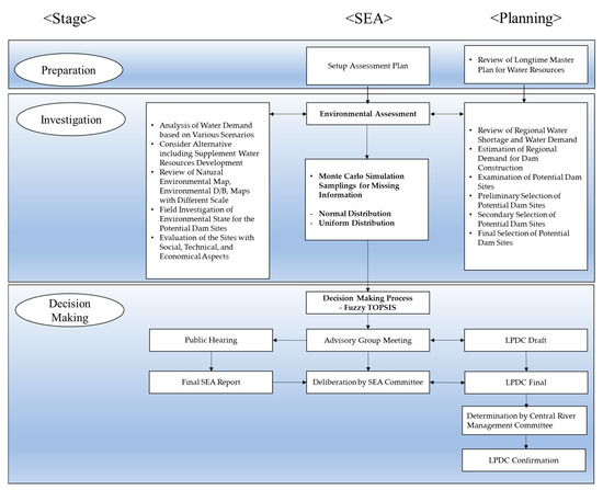
This study evaluated a fuzzy technique for order performance by similarity to ideal solution (TOPSIS) as a multicriteria decision making system that compensates for missing information with undefined weight factor criteria. The suggested Fuzzy TOPSIS was applied to ten potential dam sites in three river basins (the Han River, the Geum River, and the Nakdong River basins) in South Korea. To assess potential dam sites, the strategic environment assessment (SEA) monitored four categories: national preservation, endangered species, water quality, and toxic environment. To consider missing information, this study applied the Monte Carlo Simulation method with uniform and normal distributions. The results show that effects of missing information generation with one fuzzy set in GB1 site of the Geum River basin are not great in fuzzy positive-ideal solution (FPIS) and fuzzy negative-ideal solution (FNIS) estimations. However, the combination of two fuzzy sets considering missing information in Gohyun stream (NG) and Hoenggye stream (NH) sites of the Nakdong River basin has a great effect on estimating FPIS, FNIS, and priority ranking in Fuzzy TOPSIS applications. The sites with the highest priority ranking in the Han River, Geum River, and Nakdong River basins based on Fuzzy TOPSIS are the Dal stream 1 (HD1), Bocheong stream 2 (GB2) and NG sites. Among the sites in all river basins, the GB2 site had the highest priority ranking. Consequently, the results coincided with findings of previous studies based on multicriteria decision making with missing information and show the applicability of Fuzzy TOPSIS when evaluating priority rankings in cases with missing information. Full article
Show Figures

Figure 1

2020

Jump to: 2023, 2021

16 pages, 3216 KiB  
Article
Development of Models for Prompt Responses from Natural Disasters
by Kichul Jung, Daeryong Park and Sangki Park
Sustainability 2020, 12(18), 7803; https://doi.org/10.3390/su12187803 - 21 Sep 2020
Cited by 2 | Viewed by 2290
Abstract
This study aims to provide an enhanced model for rapid responses from natural disasters by estimating the maximum structural displacement. The linear regression, support vector machine, and Gaussian process regression (GPR) models were applied to obtain displacement estimates. Further, normalization (NM) and standardization [...] Read more.
This study aims to provide an enhanced model for rapid responses from natural disasters by estimating the maximum structural displacement. The linear regression, support vector machine, and Gaussian process regression (GPR) models were applied to obtain displacement estimates. Further, normalization (NM) and standardization (SD) of variables, and principal component analysis (PCA) were applied to improve model performance. The k-fold cross-validation approach was used to assess the results from the models based on the root-mean-square error and the R-squared indices. According to the results, the GPR model with NM and SD tended to provide the best estimates among the three models. The model that was based on a PCA value of 97% yielded better displacement estimation than the models with PCA values of 95% and 100%. Based on the displacement estimation, the maximum inter-story drift ratio was used to produce the fragility curve that can be used for risk assessment. The fragility curve parameters obtained from the actual numerical and predicted models were investigated and yielded similar responses. The proposed model can thus provide accurate and quick responses in disaster case by rapidly predicting the structural damage information. Full article
Show Figures

Figure 1

19 pages, 7967 KiB  
Article
Evaluation of Water Quality Interaction by Dam and Weir Operation Using SWAT in the Nakdong River Basin of South Korea
by Jiwan Lee, Yonggwan Lee, Soyoung Woo, Wonjin Kim and Seongjoon Kim
Sustainability 2020, 12(17), 6845; https://doi.org/10.3390/su12176845 - 23 Aug 2020
Cited by 10 | Viewed by 3936
Abstract
The purpose of this study was to evaluate the streamflow and water quality (SS, T-N, and T-P) interaction of the Nakdong river basin (23,609.3 km2) by simulating dam and weir operation scenarios using the Soil and Water Assessment Tool (SWAT). The [...] Read more.
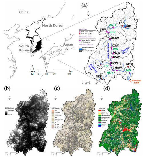
The purpose of this study was to evaluate the streamflow and water quality (SS, T-N, and T-P) interaction of the Nakdong river basin (23,609.3 km2) by simulating dam and weir operation scenarios using the Soil and Water Assessment Tool (SWAT). The operation scenarios tested were dam control (Scenario 1), dam control and weir gate control (Scenario 2), dam control and sequential release of the weirs with a one-month interval between each weir (Scenario 3), dam control and weir gate full open (Scenario 4), dam control and weir gate sequential full open (Scenario 5), weir gate control (Scenario 6), weir gate full open (Scenario 7), and weir gate sequential full open (Scenario 8). Before evaluation, the SWAT was calibrated and validated using 13 years (2005–2017) of daily multi-purpose dam inflow data from five locations ((Andong Dam (ADD), Imha Dam (IHD), Hapcheon Dam (HCD), Namkang Dam (NKD), and Milyang Dam (MYD))multi-function weir inflow data from seven locations (Sangju Weir (SJW), Gumi Weir (GMW), Chilgok Weir (CGW), Gangjeong-Goryeong Weir (GJW), Dalseong Weir (DSW), Hapcheon-Changnyeong Weir (HCW), and Changnyeong-Haman Weir (HAW)), and monthly water quality monitoring data from six locations (Andong-4 (AD-4), Sangju (SJ-2), Waegwan (WG), Hapcheon (HC), Namkang-4 (NK-4), and Mulgeum (MG). For the dam inflows and dam storage, the Nash-Sutcliffe efficiency (NSE) was 0.59~0.78, and the coefficient of determination (R2) was 0.71~0.90. For water quality, the R2 values of SS, T-N, and T-P were 0.58~0.83, 0.53~0.68, and 0.56~0.79, respectively. For the eight dam and weir release scenarios suggested by the Ministry of Environment, Scenarios 4 and 8 exhibited water quality improvement effects compared to the observed data. Full article
Show Figures

Figure 1

24 pages, 5596 KiB  
Article
Comparison of Long Short-Term Memory and Weighted Regressions on Time, Discharge, and Season Models for Nitrate-N Load Estimation
by Kichul Jung, Myoung-Jin Um, Momcilo Markus and Daeryong Park
Sustainability 2020, 12(15), 5942; https://doi.org/10.3390/su12155942 - 23 Jul 2020
Cited by 5 | Viewed by 2361
Abstract
The long short-term memory (LSTM) model has been widely used for a broad range of applications entailing the estimation of variables in different fields to improve water quality management in rivers. The main objectives of this study are (1) to develop a novel [...] Read more.
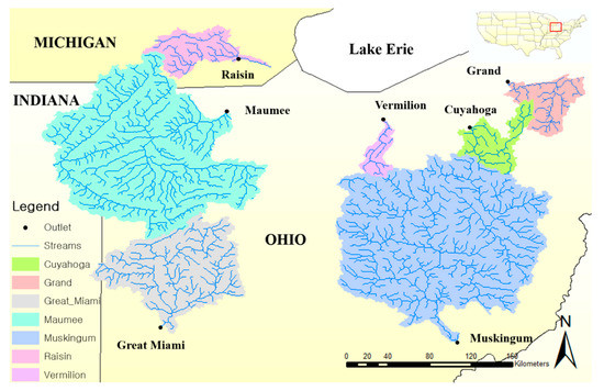
The long short-term memory (LSTM) model has been widely used for a broad range of applications entailing the estimation of variables in different fields to improve water quality management in rivers. The main objectives of this study are (1) to develop a novel LSTM-based model for the estimation of nitrate-N loads, which adversely affect water resources, and (2) to evaluate the performance of the model by comparing it with that of Monte Carlo sub-sampling and the weighted regressions on time discharge and season (WRTDS) model. We evaluated the model performance using various numbers of hidden layers, ranging from one to four, in the LSTM model to determine the appropriate number of hidden layers; furthermore, we applied the sampling frequencies of 6, 12, and 24 to assess their impact. Seven polluted river basins in the United States were used for analysis, and the relative root mean squared error (rRMSE) and the mean percentage error (MPE) metrics were applied for the validation of the model estimates. The proposed model achieved accurate nitrate-N load estimates using three to four hidden layers, and improved model performance was observed when the sampling frequency was increased. The differences among the results obtained using the LSTM model were examined based on a binning technique via a log-log plot of nitrate-N concentration against discharge. The binning analysis showed that the slope obtained from the average rates of discharge and low discharge values apparently influenced the estimates. Furthermore, box plot analyses of the statistical indices such as rRMSE and MPE demonstrate that the LSTM model seems to exhibit better performance than the WRTDS model. The results of the examination demonstrate that the LSTM model may be a good alternative with regard to estimating nitrate-N loads for the control of water quality constituents. Full article
Show Figures

Figure 1

Back to TopTop