Assessing the Extent of Historical, Current, and Future Land Use Systems in Uganda

 , , ,
, , ,
Abstract
:1. Introduction
2. Materials and Methods
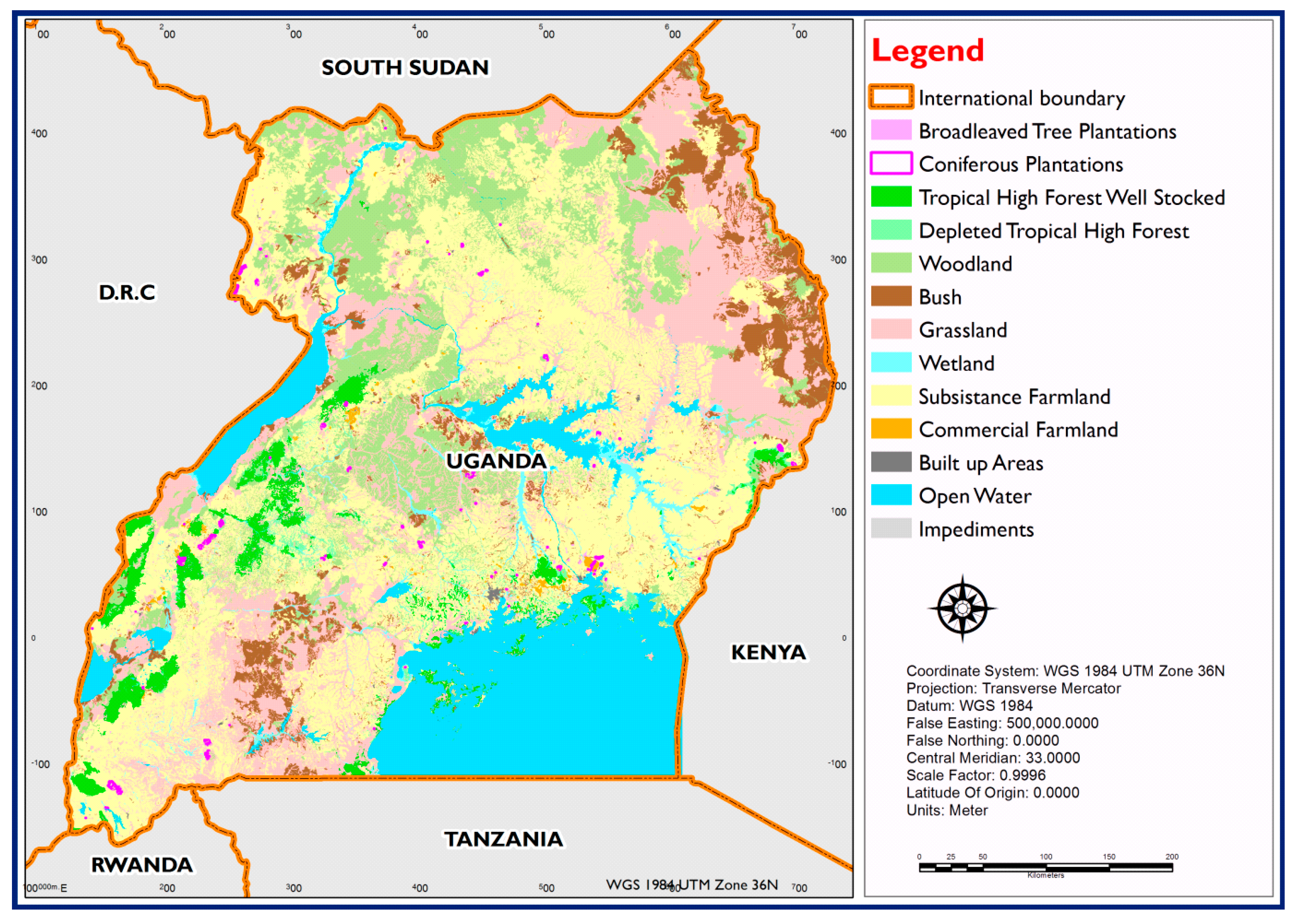
2.1. Study Area
2.2. Acquisition of Land Use/Cover Data
2.2.1. Processing of 1990 Land Use/Cover Data
2.2.2. Processing of 2015 Land Use/Cover Data
2.3. Characterization of Land Use Systems
2.3.1. Definition of Land Use System
2.3.2. Criteria for the Definition of Land Use Systems
- Similarity in the broad land cover classes;
- Similarity in terms of protection status;
- Presence and density of livestock activities.
2.3.3. Steps of Characterizing Land Use Systems
- Step 1: The detailed land use/cover classes were aggregated into 8 classes (forests, grasslands, shrubs, crops and crop mosaics (agricultural land), wetlands, shrubs and bushlands, bare land areas, and open water).
- Step 2: Irrigated land was identified and overlaid with the map generated in step 1 to create a subclass of irrigated agricultural land. Irrigated land is land equipped with infrastructure for irrigation and this was identified from the 2015 irrigation map for Uganda.
- Step 3: The protected area layer was overlaid with the layer generated under step 2 for protected land cover (such as protected forest or grassland). Protected areas are areas gazetted for wildlife conservation and they were identified from the protected areas 2014 map for Uganda.
- Step 4: Livestock intensity was estimated using the Tropical Livestock Unit based on the Ministry of Agriculture, Animal Industry and Fisheries (MAAIF) Uganda Census of Agriculture data (2008/2009) and overlaid with the layer generated under step 3 to define grassland, shrubs, and sparse shrub and herbaceous subclasses based on the livestock intensity.
- Step 5: For forests, wetlands, and agricultural lands, if the overlay with livestock indicated a moderate or high livestock density, the land use system was considered as a combination of forestry, wetlands, and crops mixed with grazing, respectively.
- Step 6: In addition to livestock presence, population presence was used to define other forest and wetland subclasses, including unprotected and protected classes for wetlands and forests with agricultural activities and virgin forest.
2.4. Validation of Land Use Systems
2.5. Projection of Land Use Systems
2.5.1. Description of Land Change Modeler
2.5.2. Transition Potential
2.5.3. Future Prediction
3. Results
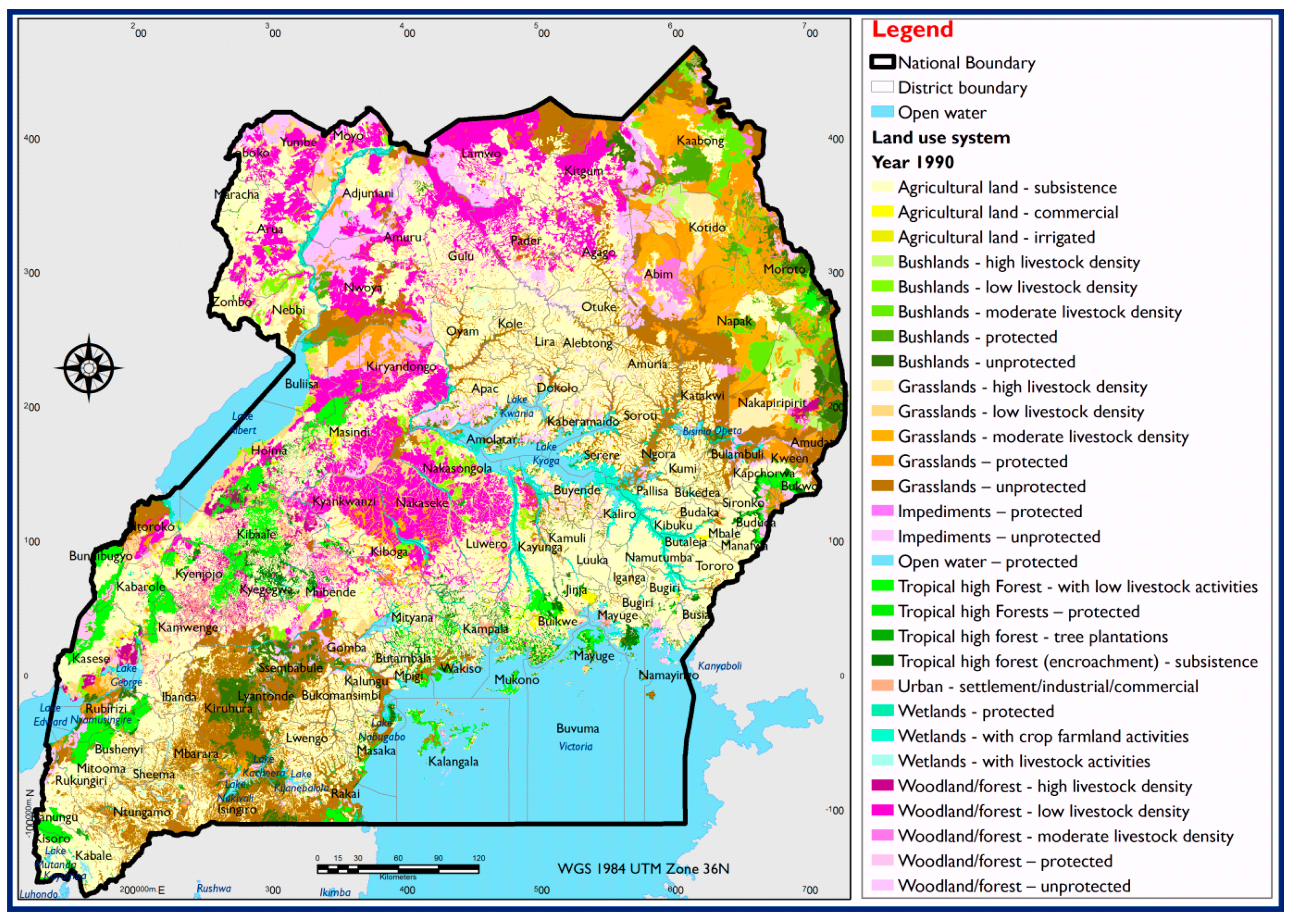
3.1. Identificaiton and Characterization of Land Use Systems in Uganda
3.1.1. Forest Land Use Systems
3.1.2. Agricultural Land Use Systems
3.1.3. Open Water Land Use System
3.1.4. Grassland Land Use System
3.1.5. Built-Up Areas Land Use System
3.1.6. Impediments Land Use System
3.1.7. Wetlands Land Use System
3.1.8. Bushlands Land Use System
3.2. The Extent of Historical and Present Land Use Systems
3.3. Projection of Land Use Systems
4. Discussion
5. Conclusions
Author Contributions
Funding
Acknowledgments
Conflicts of Interest
References
- Newbold, T.; Hudson, L.N.; Hill, S.L.; Contu, S.; Lysenko, I.; Senior, R.A.; Börger, L.; Bennett, D.J.; Choimes, A.; Collen, B.; et al. Global effects of land use on local terrestrial biodiversity. Nature 2015, 520, 45. [Google Scholar] [CrossRef] [PubMed] [Green Version]
- Popp, A.; Calvin, K.; Fujimori, S.; Havlik, P.; Humpenöder, F.; Stehfest, E.; Stehfest, E.; Bodirsky, B.L.; Dietrich, J.P.; Doelmann, J.C.; et al. Land-use futures in the shared socio-economic pathways. Glob. Environ. Chang. 2017, 42, 331–345. [Google Scholar] [CrossRef]
- Sambou, S.; Lykke, A.M.; Sambou, H.; Guiro, I.; Sambou, B.; Mbow, C. Land use-land cover change and drivers of deforestation in the Patako protected area (Center-West of Senegal). Am. J. Environ. Prot. 2015, 4, 306–317. [Google Scholar] [CrossRef]
- Samndong, R.A.; Bush, G.; Vatn, A.; Chapman, M. Institutional analysis of causes of deforestation in REDD+ pilot sites in the Equateur province: Implication for REDD+ in the Democratic Republic of Congo. Land Use Policy 2018, 76, 664–674. [Google Scholar] [CrossRef]
- Godar, J.; Gardner, T.A.; Tizado, E.J.; Pacheco, P. Actor-specific contributions to the deforestation slowdown in the Brazilian Amazon. Proc. Natl. Acad. Sci. USA 2014, 111, 15591–15596. [Google Scholar] [CrossRef] [PubMed] [Green Version]
- Specht, M.J.; Pinto, S.R.R.; Albuquerque, U.P.; Tabarelli, M.; Melo, F.P. Burning biodiversity: Fuelwood harvesting causes forest degradation in human-dominated tropical landscapes. Glob. Ecol. Conserv. 2015, 3, 200–209. [Google Scholar] [CrossRef]
- Smith, P.; Clark, H.; Dong, H.; Elsiddig, E.A.; Haberl, H.; Harper, R.; House, J.; Jafari, M.; Masera, O.; Mbow, C.; et al. Agriculture, forestry and other land use (AFOLU). In Climate Change 2014: Mitigation of Climate Change. IPCC Working Group III Contribution to AR5; Cambridge University Press: Cambridge, UK, 2014. [Google Scholar]
- Lawrence, D.; Vandecar, K. Effects of tropical deforestation on climate and agriculture. Nat. Clim. Chang. 2015, 5, 27. [Google Scholar] [CrossRef]
- Lapola, D.M.; Martinelli, L.A.; Peres, C.A.; Ometto, J.P.; Ferreira, M.E.; Nobre, C.A.; Aguiar, A.P.D.; Bustamante, M.M.; Cardoso, M.F.; Costa, M.H.; et al. Pervasive transition of the Brazilian land-use system. Nat. Clim. Chang. 2014, 4, 27. [Google Scholar] [CrossRef]
- Barni, P.E.; Fearnside, P.M.; de Alencastro Graça, P.M.L. Simulating deforestation and carbon loss in Amazonia: Impacts in Brazil’s Roraima state from reconstructing Highway BR-319 (Manaus-Porto Velho). Environ. Manag. 2015, 55, 259–278. [Google Scholar] [CrossRef] [PubMed]
- Alkama, R.; Cescatti, A. Biophysical climate impacts of recent changes in global forest cover. Science 2016, 351, 600–604. [Google Scholar] [CrossRef] [PubMed] [Green Version]
- Kweka, E.J.; Kimaro, E.E.; Munga, S. Effect of deforestation and land use changes on mosquito productivity and development in western Kenya highlands: Implication for malaria risk. Front. Public Health 2016, 4, 238. [Google Scholar] [CrossRef] [PubMed]
- Were, K.O.; Singh, B.R.; Dick, Ø.B. Effects of land cover changes on soil organic carbon and total nitrogen stocks in the Eastern Mau Forest Reserve, Kenya. In Sustainable Intensification to Advance Food Security and Enhance Climate Resilience in Africa; Springer: Cham, Switzerland, 2015; pp. 113–133. [Google Scholar]
- Natkhin, M.; Dietrich, O.; Schäfer, M.P.; Lischeid, G. The effects of climate and changing land use on the discharge regime of a small catchment in Tanzania. Reg. Environ. Chang. 2015, 15, 1269–1280. [Google Scholar] [CrossRef]
- Rawat, J.S.; Kumar, M. Monitoring land use/cover change using remote sensing and GIS techniques: A case study of Hawalbagh block, district Almora, Uttarakhand, India. Egypt. J. Remote Sens. Space Sci. 2015, 18, 77–84. [Google Scholar] [CrossRef]
- Zhang, F.; Zhan, J.; Zhang, Q.; Yao, L.; Liu, W. Impacts of land use/cover change on terrestrial carbon stocks in Uganda. Phys. Chem. Earth Parts A/B/C 2017, 101, 195–203. [Google Scholar] [CrossRef]
- Yang, C.; Rottensteiner, F.; Heipke, C. Classification of land cover and land use based on convolutional neural networks. ISPRS Ann. Photogramm. Remote Sens. Spat. Inf. Sci. 2018, 4, 251–258. [Google Scholar] [CrossRef]
- Lillesand, T.; Kiefer, R.W.; Chipman, J. Remote Sensing and Image Interpretation; John Wiley & Sons: Hoboken, NJ, USA, 2014. [Google Scholar]
- Masette, M.; Isabirye-Basuta, G.; Baranga, D.; Chemurot, M. Levels of tannins in fruit diet of grey-cheeked mangabeys (Lophocebus ugandae, Groves) in Lake Victoria Basin forest reserves. J. Ecol. Nat. Environ. 2015, 7, 146–157. [Google Scholar]
- Shaban, K.S.; Okumu, J.O.; Paul, O.; Joseph, O. Assessing community-based organizations’ influence on trees and grass planting for forest, soil and water management around Mt. Elgon National Park in Uganda. For. Trees Livelihoods 2016, 25, 161–172. [Google Scholar] [CrossRef]
- Arinaitwe, K.; Rose, N.L.; Muir, D.C.; Kiremire, B.T.; Balirwa, J.S.; Teixeira, C. Historical deposition of persistent organic pollutants in Lake Victoria and two alpine equatorial lakes from East Africa: Insights into atmospheric deposition from sedimentation profiles. Chemosphere 2016, 144, 1815–1822. [Google Scholar] [CrossRef] [PubMed]
- Kayima, J.K.; Mayo, A.W.; Nobert, J. Ecological Characteristics and Morphological Features of the Lubigi Wetland in Uganda. Environ. Ecol. Res. 2018, 6, 218–228. [Google Scholar] [CrossRef]
- Gabiri, G.; Obando, J.A.; Tenywa, M.M.; Majaliwa, J.G.; Kizza, C.L.; Zizinga, A.; Buruchara, R. Soil and nutrient losses under cultivated bush and climbing beans on terraced humid highland slopes of Southwestern Uganda. J. Sci. Res. Rep. 2015, 8, 1–16. [Google Scholar] [CrossRef]
- Musau, J.; Sang, J.; Gathenya, J.; Luedeling, E. Hydrological responses to climate change in Mt. Elgon watersheds. J. Hydrol. Reg. Stud. 2015, 3, 233–246. [Google Scholar] [CrossRef]
- Nakileza, B.R.; Majaliwa, M.J.; Wandera, A.; Nantumbwe, C.M. Enhancing resilience to landslide disaster risks through rehabilitation of slide scars by local communities in Mt. Elgon, Uganda. Jàmbá J. Disaster Risk Stud. 2017, 9, 1–11. [Google Scholar]
- Nakalembe, C.; Dempewolf, J.; Justice, C. Agricultural land use change in Karamoja region, Uganda. Land Use Policy 2017, 62, 2–12. [Google Scholar] [CrossRef]
- Li, J.; Oyana, T.J.; Mukwaya, P.I. An examination of historical and future land use changes in Uganda using change detection methods and agent-based modelling. Afr. Geogr. Rev. 2016, 35, 247–271. [Google Scholar] [CrossRef]
- Solberg, S.; May, J.; Bogren, W.; Breidenbach, J.; Torp, T.; Gizachew, B. Interferometric SAR DEMs for Forest Change in Uganda 2000–2012. Remote Sens. 2018, 10, 228. [Google Scholar] [CrossRef]
- Halmy, M.W.A.; Gessler, P.E.; Hicke, J.A.; Salem, B.B. Land use/land cover change detection and prediction in the north-western coastal desert of Egypt using Markov-CA. Appl. Geogr. 2015, 63, 101–112. [Google Scholar] [CrossRef]
- Uganda Bureau of Statistics. The National Population and Housing Census 2014–Main Report; Uganda Bureau of Statistics: Kampala, Uganda, 2016. [Google Scholar]
- Mwanjalolo, M.G.J.; Bernard, B.; Paul, M.I.; Joshua, W.; Sophie, K.; Cotilda, N.; Bob, N.; John, D.; Edward, S.; Barbara, N. Assessing the Extent of Historical, Current, and Future Land Use Systems in Uganda. Land 2018, 7, 132. [Google Scholar]
- Driessen, P.M.; Konijn, N.T. Land-Use Systems Analysis; WAU and Interdisciplinary Research (INRES): Malang, Indonesia, 1992. [Google Scholar]
- Pérez-Vega, A.; Mas, J.F.; Ligmann-Zielinska, A. Comparing two approaches to land use/cover change modeling and their implications for the assessment of biodiversity loss in a deciduous tropical forest. Environ. Model. Softw. 2012, 29, 11–23. [Google Scholar] [CrossRef]
- Dixon, J.; Tanyeri-Abur, A.; Wattenbach, H. Context and Framework for Approaches to Assessing the Impact of Globalization on Smallholders. In Approaches to Assessing the Impact of Globalization on African Smallholders: Household and Village Economy Modeling, Proceedings of Working Session Globalization and the African Smallholder Study; Dixon, J., Taniguchi, K., Wattenbach, H., Eds.; FAO and World Bank: Rome, Italy, 2003. [Google Scholar]
- Rukundo, B. Implications of Land Governance on Natural Resources Management: The Case of Land-Use and Forest-Cover Change in Kibaale District, Uganda. Ph.D. Thesis, Technische Universität München, München, Germany, 2013. [Google Scholar]
- Brink, A.B.; Eva, H.D. Monitoring 25 years of land cover change dynamics in Africa: A sample based remote sensing approach. Appl. Geogr. 2009, 29, 501–512. [Google Scholar] [CrossRef] [Green Version]
- Améztegui, A.; Brotons, L.; Coll, L. Land-use changes as major drivers of mountain pine (Pinus uncinata Ram.) expansion in the Pyrenees. Glob. Ecol. Biogeogr. 2010, 19, 632–641. [Google Scholar] [CrossRef]
- Ebanyat, P.; Ridder, N.; Jager, A.; Delve, R.J.; Bekunda, M.A.; Giller, K.E. Drivers of land use change and household determinants of sustainability in smallholder farming systems of Eastern Uganda. Popul. Environ. 2010, 31, 474–506. [Google Scholar] [CrossRef] [PubMed] [Green Version]
- Mwavu, E.N.; Witkowski, E.T.F. Land-use and cover changes (1988–2002) around Budongo forest reserve, NW Uganda: Implications for forest and woodland sustainability. Land Degrad. Dev. 2008, 19, 606–622. [Google Scholar] [CrossRef]
- Obua, J.; Harding, D.M. Visitor characteristics and attitudes towards Kibale National Park, Uganda. Tour. Manag. 1996, 17, 495–505. [Google Scholar] [CrossRef]
- Van Alstine, J.; Manyindo, J.; Smith, L.; Dixon, J.; AmanigaRuhanga, I. Resource governance dynamics: The challenge of ‘new oil’ in Uganda. Resour. Policy 2014, 40, 48–58. [Google Scholar] [CrossRef]
- Obua, J.; Agea, J.G. Forests and Forestry in Uganda. Degraded Forests in Eastern Africa: Management and Restoration; Bongers, F., Tennigkeit, T., Eds.; Earthscan Ltd.: London, UK, 2010; pp. 65–88. [Google Scholar]
- Egeru, A.; Wasonga, O.; Kyagulanyi, J.; Majaliwa, G.M.; MacOpiyo, L.; Mburu, J. Spatio-temporal dynamics of forage and land cover changes in Karamoja sub-region, Uganda. Pastoralism 2014, 4, 6. [Google Scholar] [CrossRef] [Green Version]
- Deininger, K.; Castagnini, R. Incidence and impact of land conflict in Uganda. J. Econ. Behav. Organ. 2006, 60, 321–345. [Google Scholar] [CrossRef]
- Bwambale, B.; Bagampadde, U.; Gidudu, A.; Martini, F. Seismic Hazard Analysis for the Albertine Region, Uganda—A Probabilistic Approach. S. Afr. J. Geol. 2015, 118, 411–424. [Google Scholar] [CrossRef]
- Jacobs, L.; Dewitte, O.; Poesen, J.; Maes, J.; Mertens, K.; Sekajugo, J.; Kervyn, M. Landslide characteristics and spatial distribution in the Rwenzori Mountains, Uganda. J. Afr. Earth Sci. 2017, 134, 917–930. [Google Scholar] [CrossRef]


| No. | Land Use/Cover Classes | Description |
|---|---|---|
| 1 | Built-up area | Urban and rural built areas |
| 2 | Bushlands | Bush, thickets, scrub (average height <4 m) |
| 3 | Commercial farmland | Monocropped, nonseasonal farming, usually with no trees |
| 4 | Grassland | Rangeland, pasture land, savannah—may include scattered tree shrubs, thickets, scrub |
| 5 | Hardwood plantation | Hard and softwood |
| 6 | Impediments | Bare rocks and land |
| 7 | Open water | Lakes, rivers, and ponds |
| 8 | Small-scale farmland | Mixed farmland, smallholding with or without scattered trees |
| 9 | Tropical high forest (well stocked) | Normally stocked |
| 10 | Tropical high forest (low stocked) | Degraded/depleted/encroached |
| 11 | Wetland | Wetland vegetation, swamps, papyrus, and other sedges |
| 12 | Woodland | Trees and shrubs (average height >4 m) |
| 13 | Softwood | Scattered woodlots |
| Transitions From–To | Submodel Name |
|---|---|
| Woodland–unprotected to agricultural land | Woodland_to_agriculture |
| Grassland–unprotected to agricultural land | Grassland_to_agriculture |
| Bushland–unprotected to agricultural land | Bushland_to_agriculture |
| No. | Land Use Systems | 1990 | 2015 | ||
|---|---|---|---|---|---|
| Area (km2) | % Area (km2) | Area (km2) | % Area (km2) | ||
| 1 | Agricultural land—commercial | 517.32 | 0.209 | 2587.71 | 1.06 |
| 2 | Agricultural land—irrigated | 28.8 | 0.012 | 46.08 | 0.02 |
| 3 | Agricultural land—subsistence | 98,073.36 | 39.683 | 107,426.6 | 44.16 |
| 4 | Bushlands—high livestock density | 1389.29 | 0.562 | 1360.66 | 0.56 |
| 5 | Bushlands—low livestock density | 111.07 | 0.045 | 452.54 | 0.19 |
| 6 | Bushlands—moderate livestock density | 2111.07 | 0.854 | 2642.54 | 1.09 |
| 7 | Bushlands—protected | 5206.78 | 2.107 | 7410.41 | 3.05 |
| 8 | Bushlands—unprotected | 5459.02 | 2.209 | 4236.81 | 1.74 |
| 9 | Grasslands—high livestock density | 3240.07 | 1.311 | 6588.38 | 2.71 |
| 10 | Grasslands—low livestock density | 7398.23 | 2.993 | 5350.85 | 2.20 |
| 11 | Grasslands—moderate livestock density | 6131.7 | 2.481 | 6534.76 | 2.69 |
| 12 | Grasslands—protected | 6648.12 | 2.690 | 27,146.2 | 11.16 |
| 13 | Grasslands—unprotected | 26,402.33 | 10.683 | 6118.32 | 2.52 |
| 14 | Impediments—protected | 9.7 | 0.004 | 34.56 | 0.01 |
| 15 | Impediments—unprotected | 11.52 | 0.005 | 51.9 | 0.02 |
| 16 | Open water—protected | 37,130.69 | 15.024 | 36,980.77 | 15.20 |
| 17 | Tropical high forest (encroachment)—subsistence | 2186.91 | 0.885 | 872.06 | 0.36 |
| 18 | Tropical high forest—tree plantations | 218.1 | 0.088 | 2420.6 | 1.00 |
| 19 | Tropical high forest—with livestock activities | 6765.05 | 2.737 | 942.69 | 0.39 |
| 20 | Tropical high forest—protected | 2715.46 | 1.099 | 3199.14 | 1.32 |
| 21 | Urban—settlement | 362.1 | 0.147 | 1340.09 | 0.55 |
| 22 | Wetlands—protected | 1963.58 | 0.795 | 6028.29 | 2.48 |
| 23 | Wetlands—with crop farmland activities | 217.43 | 0.088 | 347.64 | 0.14 |
| 24 | Wetlands—with livestock activities | 528.3 | 0.214 | 487.72 | 0.20 |
| 25 | Woodland/forest—high livestock density | 1851.1 | 0.749 | 685.19 | 0.28 |
| 26 | Woodland/forest—low livestock density | 5481.56 | 2.218 | 1246.91 | 0.51 |
| 27 | Woodland/forest—protected | 4092.06 | 1.656 | 6822.21 | 2.80 |
| 28 | Woodland/forest—unprotected | 9612.57 | 3.889 | 867.25 | 0.36 |
| 29 | Woodland/forest —moderate livestock density | 11,281.56 | 4.565 | 3024.91 | 1.24 |
| No. | Land Use Systems | 2040 | |
|---|---|---|---|
| Area (km2) | % Area (km2) | ||
| 1 | Agricultural land—commercial | 2875.97 | 1.191 |
| 2 | Agricultural land—irrigated | 96.08 | 0.040 |
| 3 | Agricultural land—subsistence | 109,713.8 | 45.452 |
| 4 | Bushlands—high livestock density | 1333.4 | 0.552 |
| 5 | Bushlands—moderate livestock density | 1273.4 | 0.528 |
| 6 | Bushlands—low livestock density | 1079.98 | 0.447 |
| 7 | Bushlands—protected | 7363.73 | 3.051 |
| 8 | Bushlands—unprotected | 4219.81 | 1.748 |
| 9 | Grasslands—high livestock density | 6578.74 | 2.725 |
| 10 | Grasslands—low livestock density | 5339.8 | 2.212 |
| 11 | Grasslands—moderate livestock density | 6529.63 | 2.705 |
| 12 | Grasslands—protected | 27,089.86 | 11.223 |
| 13 | Grasslands—unprotected | 5966.88 | 2.472 |
| 14 | Impediments—protected | 28.8 | 0.012 |
| 15 | Impediments—unprotected | 51.9 | 0.022 |
| 16 | Open water—protected | 36,984.29 | 15.322 |
| 17 | Tropical high forest (encroachment)—subsistence | 869.87 | 0.360 |
| 18 | Tropical high forest—tree plantations | 2407.54 | 0.997 |
| 19 | Tropical high forest—with livestock activities | 421.69 | 0.175 |
| 20 | Tropical high forest—protected | 3207.35 | 1.329 |
| 21 | Urban—settlement | 1432.26 | 0.593 |
| 22 | Wetlands—protected | 6013.49 | 2.491 |
| 23 | Wetlands—with crop farmland activities | 647.64 | 0.268 |
| 24 | Wetlands—with livestock activities | 487.98 | 0.202 |
| 25 | Woodland/forest—high livestock density | 235.59 | 0.098 |
| 26 | Woodland/forest—low livestock density | 1953.95 | 0.809 |
| 27 | Woodland/forest—protected | 6788.46 | 2.812 |
| 28 | Woodland/forest—unprotected | 287.27 | 0.119 |
| 29 | Woodland/forest—moderate livestock density | 102.5 | 0.042 |
© 2018 by the authors. Licensee MDPI, Basel, Switzerland. This article is an open access article distributed under the terms and conditions of the Creative Commons Attribution (CC BY) license (http://creativecommons.org/licenses/by/4.0/).
Share and Cite
Mwanjalolo, M.G.J.; Bernard, B.; Paul, M.I.; Joshua, W.; Sophie, K.; Cotilda, N.; Bob, N.; John, D.; Edward, S.; Barbara, N. Assessing the Extent of Historical, Current, and Future Land Use Systems in Uganda. Land 2018, 7, 132. https://doi.org/10.3390/land7040132
Mwanjalolo MGJ, Bernard B, Paul MI, Joshua W, Sophie K, Cotilda N, Bob N, John D, Edward S, Barbara N. Assessing the Extent of Historical, Current, and Future Land Use Systems in Uganda. Land. 2018; 7(4):132. https://doi.org/10.3390/land7040132
Chicago/Turabian StyleMwanjalolo, Majaliwa Gilbert Jackson, Barasa Bernard, Mukwaya Isolo Paul, Wanyama Joshua, Kutegeka Sophie, Nakyeyune Cotilda, Nakileza Bob, Diisi John, Ssenyonjo Edward, and Nakangu Barbara. 2018. "Assessing the Extent of Historical, Current, and Future Land Use Systems in Uganda" Land 7, no. 4: 132. https://doi.org/10.3390/land7040132
APA StyleMwanjalolo, M. G. J., Bernard, B., Paul, M. I., Joshua, W., Sophie, K., Cotilda, N., Bob, N., John, D., Edward, S., & Barbara, N. (2018). Assessing the Extent of Historical, Current, and Future Land Use Systems in Uganda. Land, 7(4), 132. https://doi.org/10.3390/land7040132