


Monitoring the Kotychi Lagoon in Western Peloponnese, Greece, Using Remote Sensing Techniques and Environmental Assessment

 , ,
, ,  and
and
Abstract
:1. Introduction
2. Materials and Methods
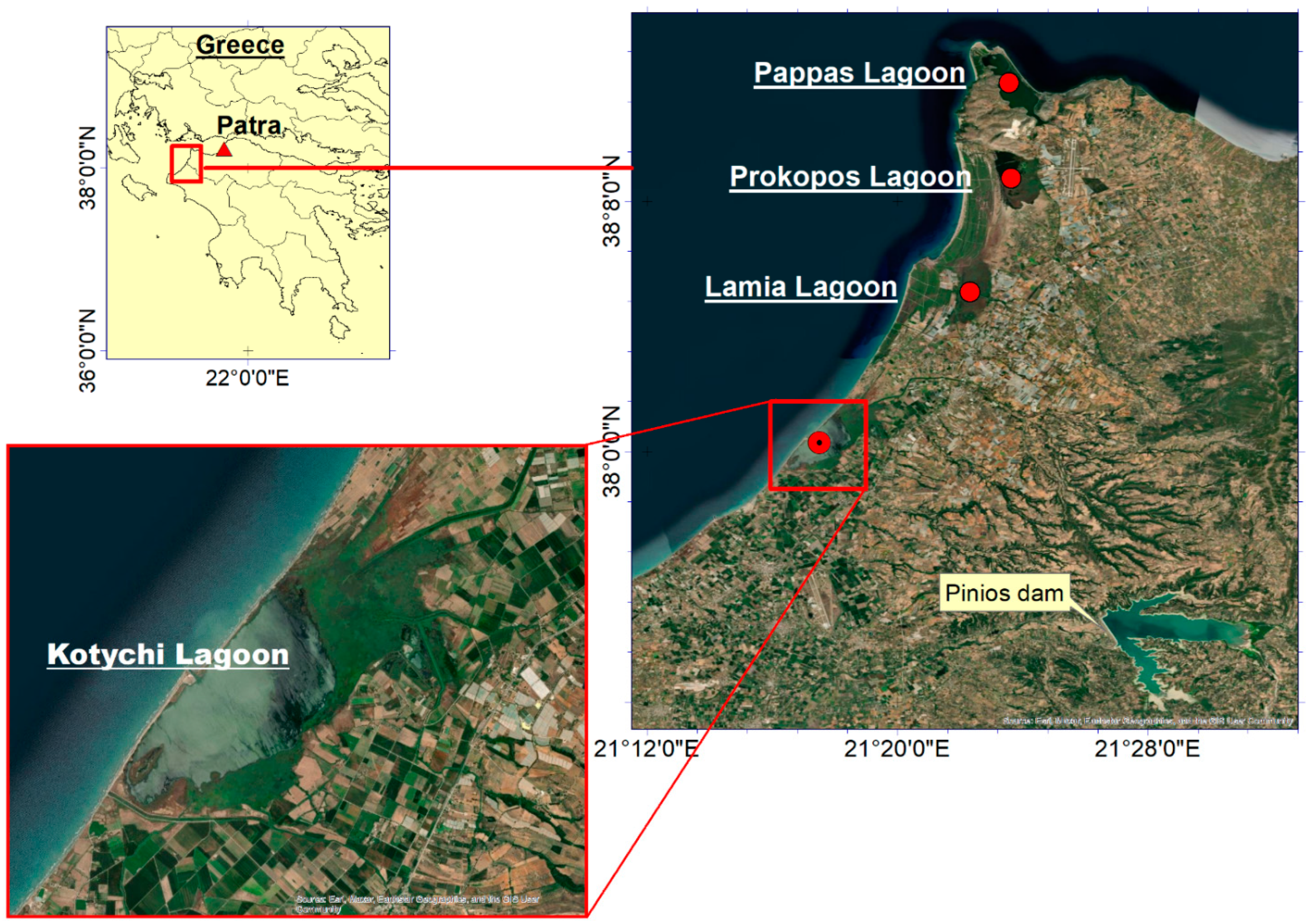
2.1. Study Area
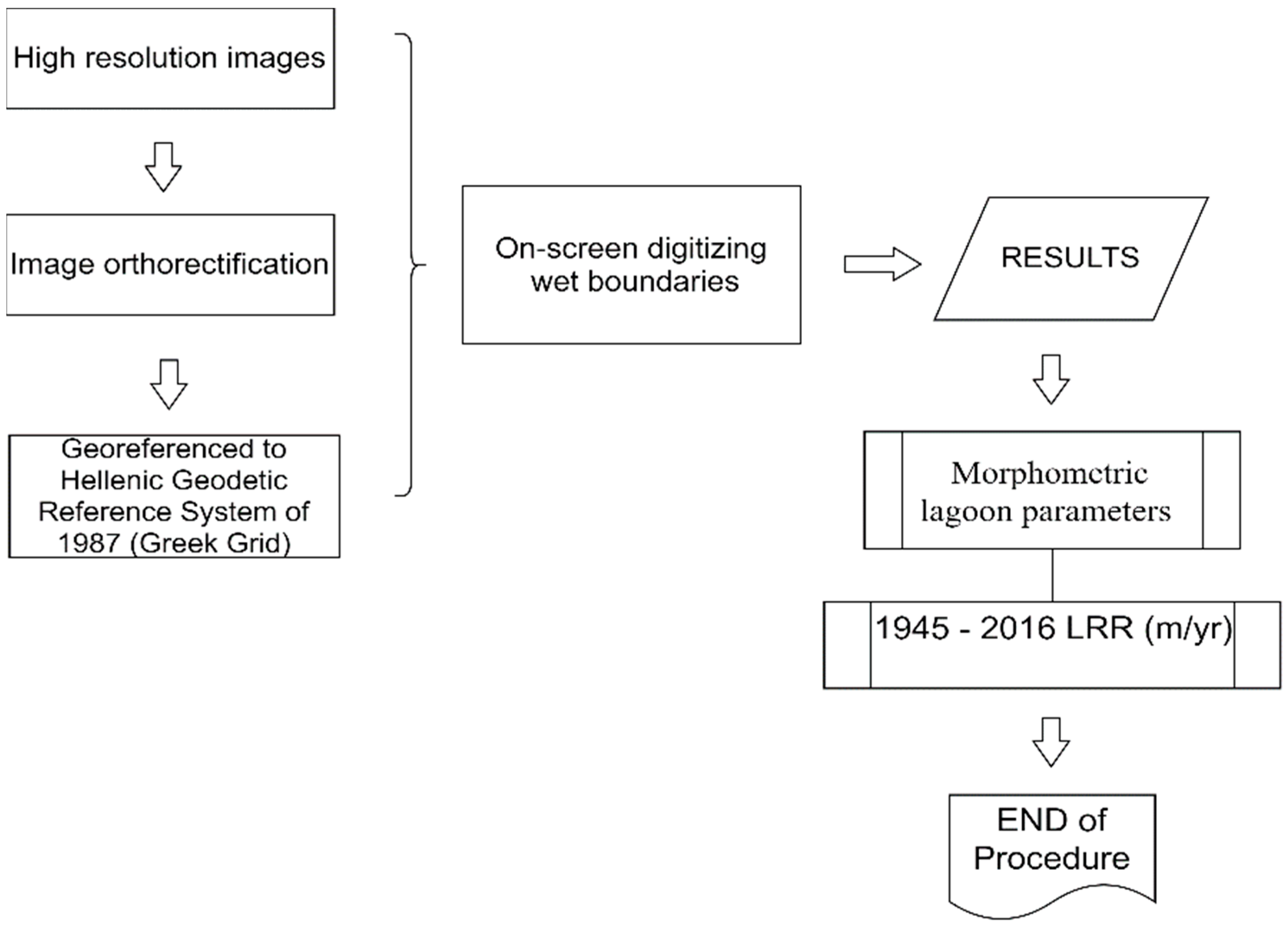
2.2. Remote Sensing Surveys
2.2.1. Materials
2.2.2. Quantitative Morphometric Parameter Estimation
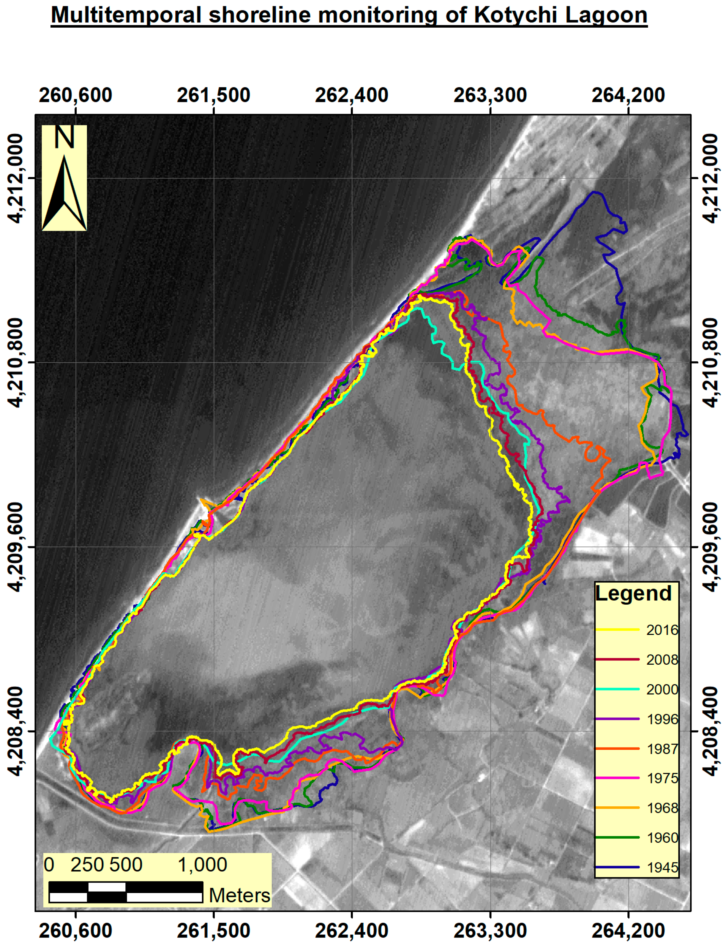
2.2.3. Estimating Changes in the Kotychi Lagoon Coastal Zone
2.2.4. Uncertainty Considerations
2.3. Physicochemical and Ecological Parameters
2.3.1. Sampling
2.3.2. Analysis of Water Samples
2.3.3. Analysis of Sediment Samples
2.3.4. Determination of Ecological Quality
3. Results
3.1. Remote Sensing
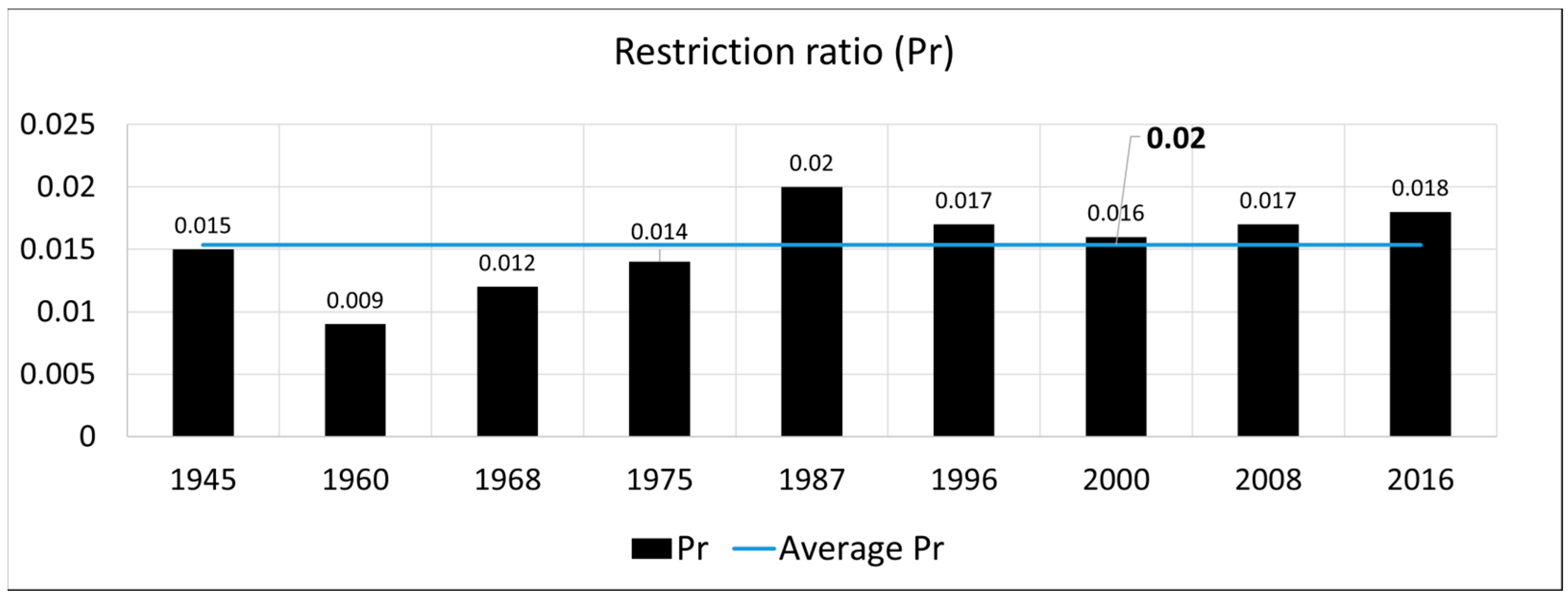
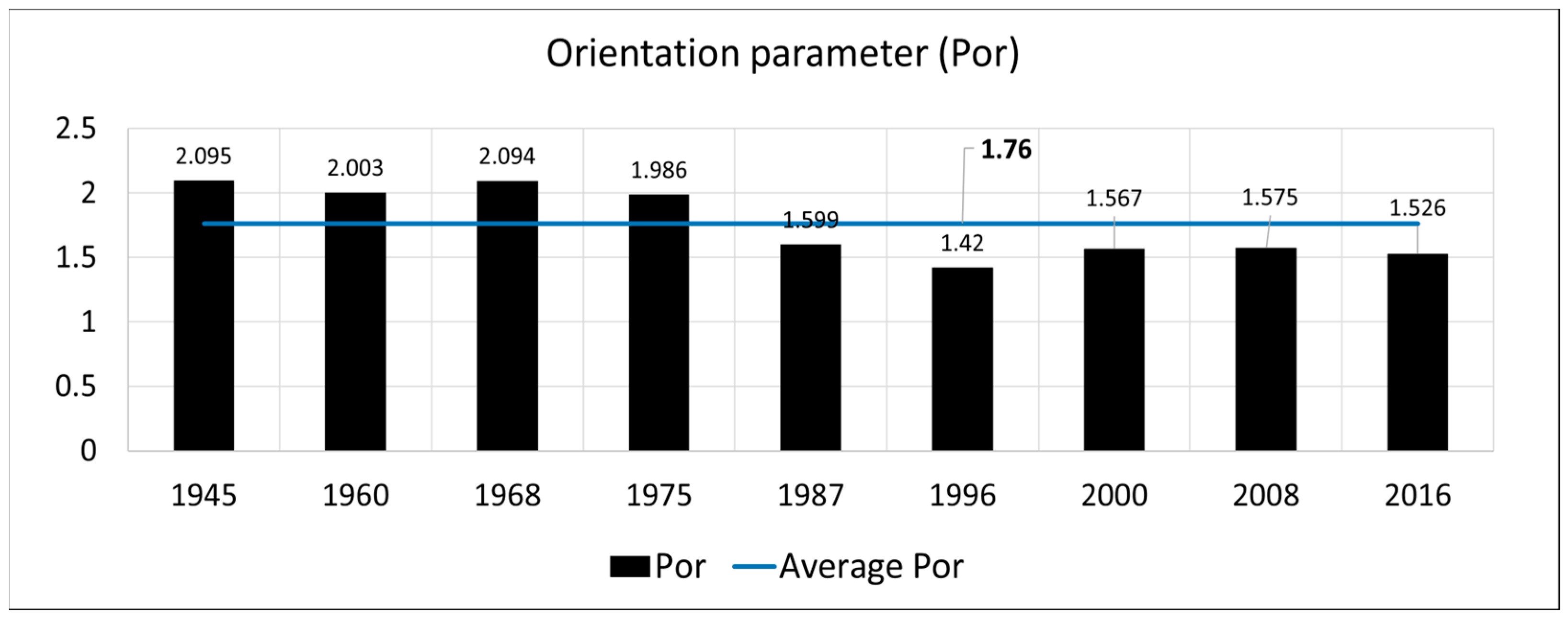
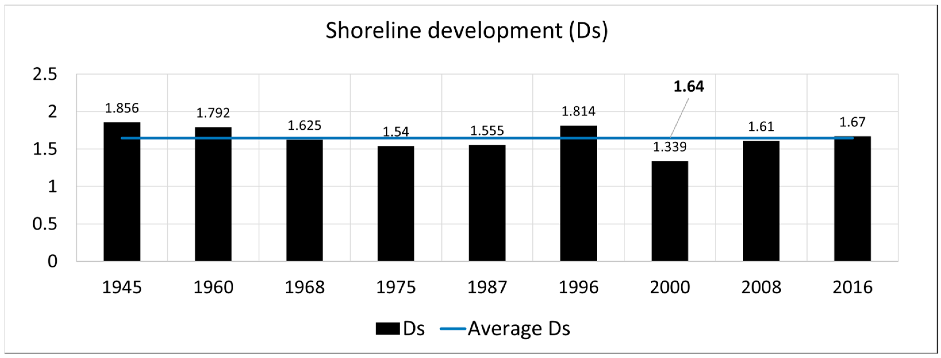
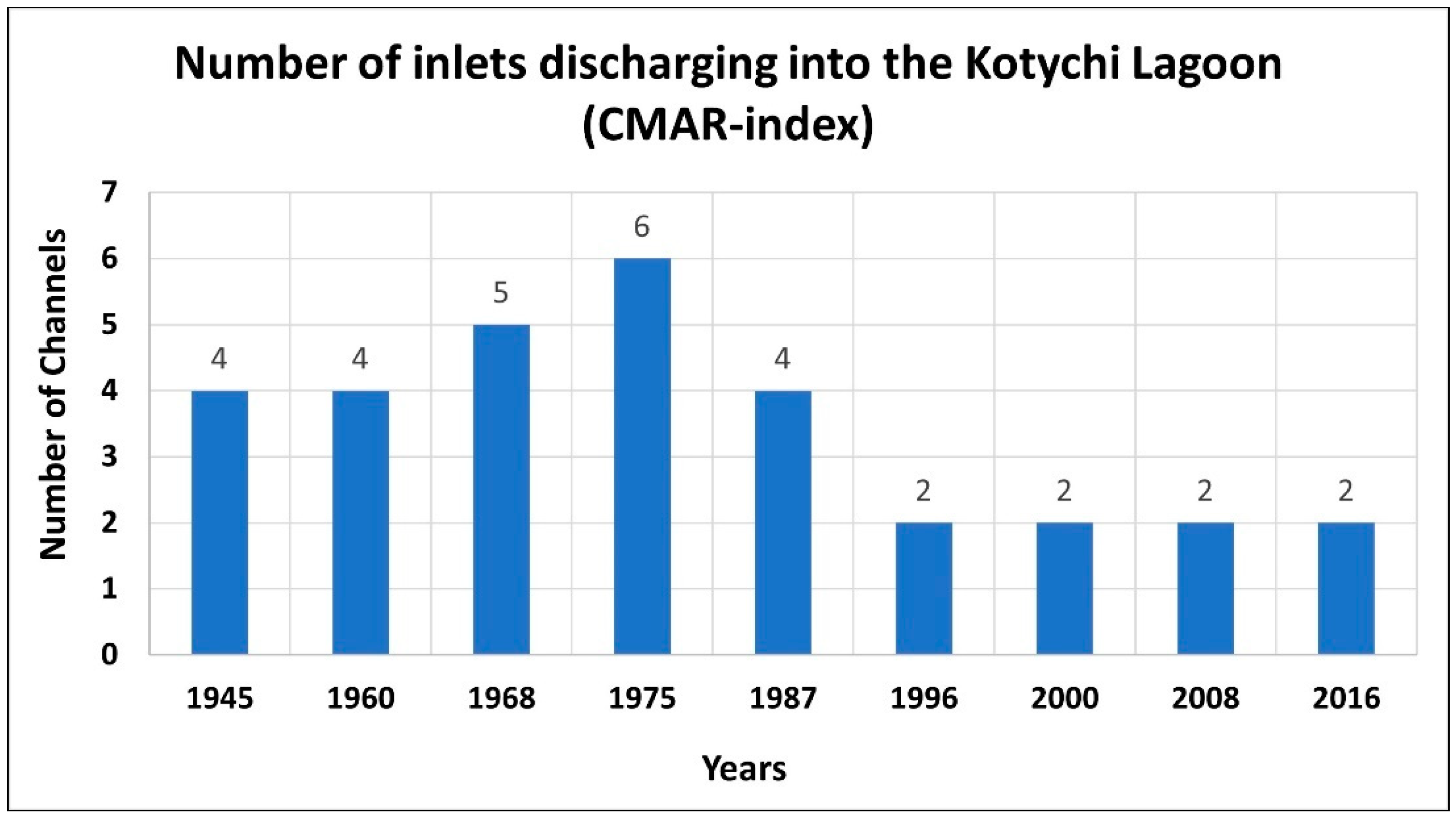
3.1.1. Estimation of Morphometric Parameters
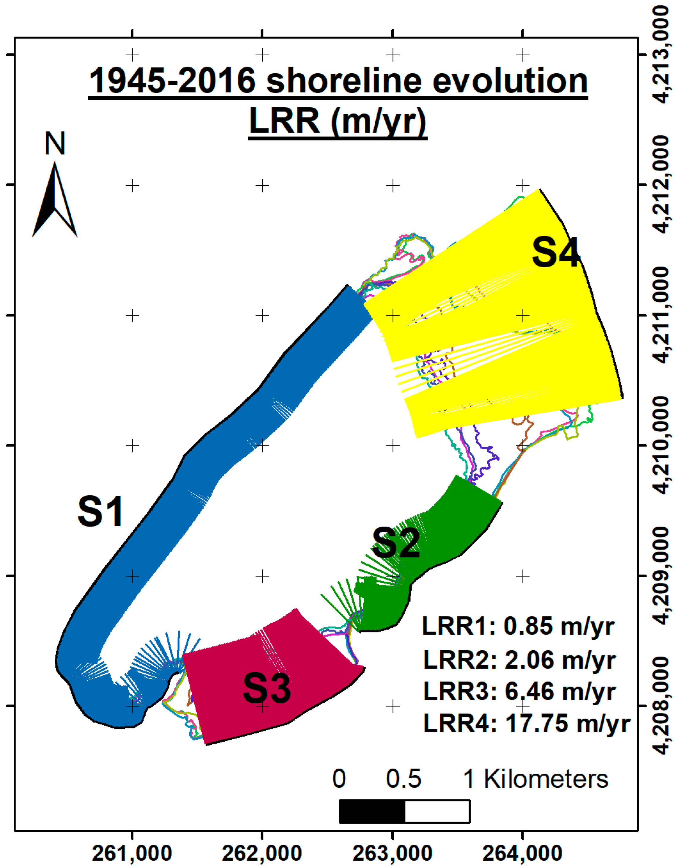
3.1.2. Kotychi Lagoon’s Littoral Zone Evolution
3.2. Water and Sediment Characteristics
3.3. Ecological Characteristics
4. Discussion
5. Conclusions
Author Contributions
Funding
Institutional Review Board Statement
Informed Consent Statement
Data Availability Statement
Acknowledgments
Conflicts of Interest
References
- Karpatne, A.; Khandelwal, A.; Chen, X.; Mithal, V.; Faghmous, J.; Kumar, V. Global Monitoring of Inland Water Dynamics: State-of-the-Art, Challenges, and Opportunities. In Computational Sustainability; Studies in Computational Intelligence; Lässig, J., Kersting, K., Morik, K., Eds.; Springer International Publishing: Cham, Switzerland, 2016; pp. 121–147. ISBN 978-3-319-31858-5. [Google Scholar]
- Avramidis, P.; Iliopoulos, G.; Kontopoulos, N.; Panagiotaras, D.; Barouchas, P.; Nikolaou, K.; Papadopoulou, P. Depositional Environments, Sediment Characteristics, Palaeoecological Analysis and Environmental Assessment of an Internationally Protected Shallow Mediterranean Lagoon, Gialova Lagoon—Navarino Bay, Greece. Earth Environ. Sci. Trans. R. Soc. Edinb. 2014, 105, 189–206. [Google Scholar] [CrossRef]
- Srichandan, S.; Kim, J.Y.; Bhadury, P.; Barik, S.K.; Muduli, P.R.; Samal, R.N.; Pattnaik, A.K.; Rastogi, G. Spatiotemporal Distribution and Composition of Phytoplankton Assemblages in a Coastal Tropical Lagoon: Chilika, India. Environ. Monit. Assess. 2015, 187, 47. [Google Scholar] [CrossRef] [PubMed]
- Ghai, R.; Hernandez, C.M.; Picazo, A.; Mizuno, C.M.; Ininbergs, K.; Díez, B.; Valas, R.; DuPont, C.L.; McMahon, K.D.; Camacho, A.; et al. Metagenomes of Mediterranean Coastal Lagoons. Sci. Rep. 2012, 2, 490. [Google Scholar] [CrossRef] [PubMed]
- Kjerfve, B. Coastal Lagoon Processes; Kjerfve, B., Ed.; Elsevier: Amsterdam, The Netherlands, 1994; ISBN 0-444-88258-8. [Google Scholar]
- Apostolopoulos, D.N.; Avramidis, P.; Nikolakopoulos, K.G. Estimating Quantitative Morphometric Parameters and Spatiotemporal Evolution of the Prokopos Lagoon Using Remote Sensing Techniques. J. Mar. Sci. Eng. 2022, 10, 931. [Google Scholar] [CrossRef]
- Kjerfve, B. Comparative Oceanography of Coastal Lagoons. In Estuarine Variability; Wolfe, D.A., Ed.; Academic Press: Cambridge, MA, USA, 1986; pp. 63–81. ISBN 978-0-12-761890-6. [Google Scholar]
- McFeeters, S.K. The Use of the Normalized Difference Water Index (NDWI) in the Delineation of Open Water Features. Int. J. Remote Sens. 1996, 17, 1425–1432. [Google Scholar] [CrossRef]
- Xu, H. Modification of Normalised Difference Water Index (NDWI) to Enhance Open Water Features in Remotely Sensed Imagery. Int. J. Remote Sens. 2006, 27, 3025–3033. [Google Scholar] [CrossRef]
- Rasuly, A.; Naghdifar, R.; Rasoli, M. Monitoring of Caspian Sea Coastline Changes Using Object-Oriented Techniques. Procedia Environ. Sci. 2010, 2, 416–426. [Google Scholar] [CrossRef]
- Bera, R.; Maiti, R. Quantitative Analysis of Erosion and Accretion (1975–2017) Using DSAS—A Study on Indian Sundarbans. Reg. Stud. Mar. Sci. 2019, 28, 100583. [Google Scholar] [CrossRef]
- Crist, E.P.; Cicone, R.C. A Physically-Based Transformation of Thematic Mapper Data—The TM Tasseled Cap. IEEE Trans. Geosci. Remote Sens. 1984, 2, 256–263. [Google Scholar] [CrossRef]
- Samarawickrama, U.; Piyaratne, D.; Ranagalage, M. Relationship between NDVI with Tasseled Cap Indices: A Remote Sensing Based Analysis. Int. J. Innov. Res. Technol. 2017, 3, 13–19. [Google Scholar]
- Chen, C.; Fu, J.; Zhang, S.; Zhao, X. Coastline Information Extraction Based on the Tasseled Cap Transformation of Landsat-8 OLI Images. Estuar. Coast. Shelf Sci. 2019, 217, 281–291. [Google Scholar] [CrossRef]
- Huang, C.; Wylie, B.; Yang, L.; Homer, C.; Zylstra, G. Derivation of a Tasselled Cap Transformation Based on Landsat 7 At-Satellite Reflectance. Int. J. Remote Sens. 2002, 23, 1741–1748. [Google Scholar] [CrossRef]
- Anders, F.J.; Byrnes, M. Accuracy of Shoreline Change Rates as Determined from Maps and Aerial Photographs. Shore Beach 1991, 59, 17–26. [Google Scholar]
- Moore, L.J. Shoreline Mapping Techniques. J. Coast. Res. 2000, 16, 111–124. [Google Scholar]
- Apostolopoulos, D.N.; Nikolakopoulos, K.G. Identifying Sandy Sites under Erosion Regime along the Prefecture of Achaia, Using Remote Sensing Techniques. J. Appl. Remote Sens. 2022, 17, 022206. [Google Scholar] [CrossRef]
- Chubarenko, B.; Koutitonsky, V.; Neves, R.; Umgiesser, G. Modeling Concepts. In Coastal Lagoons: Ecosystem Process and Modeling for Sustainable Use and Development; CRC: Washigton, DC, USA, 2005; pp. 231–306. [Google Scholar]
- Pérez-Ruzafa, A.; Mompeán, M.C.; Marcos, C. Hydrographic, Geomorphologic and Fish Assemblage Relationships in Coastal Lagoons. In Proceedings of the Lagoons and Coastal Wetlands in the Global Change Context: Impacts and Management Issues: Selected Papers of the International Conference “CoastWetChange”, Venice, Italy, 26–28 April 2004; Viaroli, P., Lasserre, P., Campostrini, P., Eds.; Springer: Dordrecht, The Netherlands, 2007; pp. 107–125. [Google Scholar]
- Kalivas, D.P.; Kollias, V.J.; Karantounias, G. A GIS for the Assessment of the Spatio-Temporal Changes of the Kotychi Lagoon, Western Peloponnese, Greece. Water Resour. Manag. 2003, 17, 19–36. [Google Scholar] [CrossRef]
- Avramidis, P.; Bouzos, D.; Antoniou, V.; Kontopoulos, N. Application of Grain-Size Trend Analysis and Spatio-Temporal Changes of Sedimentation, as a Tool for Lagoon Management. Case Study: The Kotychi Lagoon (Western Greece). Geol. Carpathica 2008, 59, 261–268. [Google Scholar]
- Emmanouilidis, A.; Katrantsiotis, C.; Norström, E.; Risberg, J.; Kylander, M.; Sheik, T.A.; Iliopoulos, G.; Avramidis, P. Middle to Late Holocene Palaeoenvironmental Study of Gialova Lagoon, SW Peloponnese, Greece. Quat. Int. 2018, 476, 46–62. [Google Scholar] [CrossRef]
- Papatheodorou, G.; Avramidis, P.; Fakiris, E.; Christodoulou, D.; Kontopoulos, N. Bed Diversity in the Shallow Water Environment of Pappas Lagoon in Greece. Int. J. Sediment Res. 2012, 27, 1–17. [Google Scholar] [CrossRef]
- Katrantsiotis, C.; Kylander, M.E.; Smittenberg, R.; Yamoah, K.K.A.; Hättestrand, M.; Avramidis, P.; Strandberg, N.A.; Norström, E. Eastern Mediterranean Hydroclimate Reconstruction over the Last 3600 Years Based on Sedimentary N-Alkanes, Their Carbon and Hydrogen Isotope Composition and XRF Data from the Gialova Lagoon, SW Greece. Quat. Sci. Rev. 2018, 194, 77–93. [Google Scholar] [CrossRef]
- Weiberg, E.; Unkel, I.; Kouli, K.; Holmgren, K.; Avramidis, P.; Bonnier, A.; Dibble, F.; Finné, M.; Izdebski, A.; Katrantsiotis, C.; et al. The Socio-Environmental History of the Peloponnese during the Holocene: Towards an Integrated Understanding of the Past. Quat. Sci. Rev. 2016, 136, 40–65. [Google Scholar] [CrossRef]
- Kraft, J.C.; John, C.; Rapp, G.R.; Gifford, J.A.; Aschenbrenner, S.E.; Stanley, E. Coastal Change and Archaeological Settings in Elis. Hesperia J. Am. Sch. Class. Stud. Athens 2005, 74, 1–39. [Google Scholar]
- Kontopoulos, N.; Koutsios, A. A Late Holocene Record of Environmental Changes from Kotihi Lagoon, Elis, Northwest Peloponnesus, Greece. Quat. Int. 2010, 225, 191–198. [Google Scholar] [CrossRef]
- Fountoulis, I.; Vassilakis, E.; Mavroulis, S.; Alexopoulos, J.; Erkeki, A. Quantification of River Valley Major Diversion Impact at Kyllini Coastal Area (W. Peloponnesus, Greece) with Remote Sensing Techniques. In Proceedings of the 2nd INQUA-IGCP-567 International Workshop on Active Tectonics, Earthquake Geology, Archaeology and Engineering, Corinth, Greece, 1 January 2011; pp. 42–45. [Google Scholar]
- Haenssler, E.; Unkel, I.; Dörfler, W.; Nadeau, M.-J. Driving Mechanisms of Holocene Lagoon Development and Barrier Accretion in Northern Elis, Peloponnese, Inferred from the Sedimentary Record of the Kotychi Lagoon. E&G Quat. Sci. J. 2014, 63, 60–77. [Google Scholar] [CrossRef]
- Himmelstoss, E.A.; Henderson, R.E.; Kratzmann, M.G.; Farris, A.S. Digital Shoreline Analysis System (DSAS) Version 5.0 User Guide; Open-File Report; No. 2018-1179; U.S. Geological Survey: Reston, VA, USA, 2018. [Google Scholar]
- Nikolakopoulos, K.; Kyriou, A.; Koukouvelas, I.; Zygouri, V.; Apostolopoulos, D. Combination of Aerial, Satellite, and UAV Photogrammetry for Mapping the Diachronic Coastline Evolution: The Case of Lefkada Island. ISPRS Int. J. Geo-Inform. 2019, 8, 489. [Google Scholar] [CrossRef] [Green Version]
- Burningham, H.; French, J. Understanding Coastal Change Using Shoreline Trend Analysis Supported by Cluster-Based Segmentation. Geomorphology 2017, 282, 131–149. [Google Scholar] [CrossRef]
- Hapke, C.J.; Himmelstoss, E.A.; Kratzmann, M.G.; List, J.H.; Thieler, E.R. National Assessment of Shoreline Change: Historical Shoreline Change along the New England and Mid-Atlantic Coasts; Open-File Report; No. 2010-1118; U.S. Geological Survey: Reston, VA, USA, 2011. [Google Scholar]
- Bekiari, V.; Avramidis, P. Data Quality in Water Analysis: Validation of Combustion-Infrared and Combustion-Chemiluminescence Methods for the Simultaneous Determination of Total Organic Carbon (TOC) and Total Nitrogen (TN). Int. J. Environ. Anal. Chem. 2014, 94, 65–76. [Google Scholar] [CrossRef]
- APHA. Standard Methods for the Examination of Water and Waste Water, 21st ed.; American Public Health Association: Washington, DC, USA, 2005. [Google Scholar]
- Avramidis, P.; Nikolaou, K.; Bekiari, V. Total Organic Carbon and Total Nitrogen in Sediments and Soils: A Comparison of the Wet Oxidation—Titration Method with the Combustion-Infrared Method. Agric. Agric. Sci. Procedia 2015, 4, 425–430. [Google Scholar] [CrossRef]
- Avramidis, P.; Bekiari, V. Application of a Catalytic Oxidation Method for the Simultaneous Determination of Total Organic Carbon and Total Nitrogen in Marine Sediments and Soils. PLoS ONE 2021, 16, e0252308. [Google Scholar] [CrossRef] [PubMed]
- Worms Editorial Board. WoRMS—World Register of Marine Species. Available online: https://www.marinespecies.org/ (accessed on 13 January 2023).
- Muxika, I.; Borja, Á.; Bald, J. Using Historical Data, Expert Judgement and Multivariate Analysis in Assessing Reference Conditions and Benthic Ecological Status, according to the European Water Framework Directive. Mar. Pollut. Bull. 2007, 55, 16–29. [Google Scholar] [CrossRef] [PubMed]
- Reizopolou, S.; Penna, M.; Boix, D.; Buchet, R.; Costas, N.; Derolez, V.; Gascon, S.; Gifre, J.; Martinoy, M.; Pardo, I.; et al. Transitional Waters Mediterranean Geographic Intercalibration Group: Benthic Invertebrates Fauna Ecological Assessment Methods; Publications Office of the European Union: Luxembourg, 2018. [Google Scholar]
- Cataudella, S.; Crosetti, D.; Massa, F. Fishery and Aquaculture Economics and Policy Division. Mediterranean Coastal Lagoons: Sustainable Management and Interactions among Aquaculture, Capture Fisheries and the Environment; General Fisheries Commission for the Mediterranean (GFCM)—Session Report; FAO: Rome, Italy, 2015; ISBN 978-92-5-108792-3. [Google Scholar]
- Tziortzis, I.; Kadis, K.; Papastegiadou, E. Use of Macrophyte assemblages for the ecological evaluation of two coastal lagoons of Greece according to WFD 2000/60/EC. J. Wetl. Biodivers. 2014, 4, 97–111. [Google Scholar]
- Fyttis, G.; Reizopoulou, S.; Papastergiadou, E. Assessing the Ecological Quality of Coastal Lagoons of Western Greece: The Response of Benthic Communities to Environmental Variability. Int. J. Environ. Sci. Dev. 2019, 10, 91–95. [Google Scholar] [CrossRef]
- Hyland, J.; Balthis, L.; Karakassis, I.; Magni, P.; Petrov, A.; Shine, J.; Vestergaard, O.; Warwick, R. Organic Carbon Content of Sediments as an Indicator of Stress in the Marine Benthos. Mar. Ecol. Prog. Ser. 2005, 295, 91–103. [Google Scholar] [CrossRef] [Green Version]


| Month/Year | Data Type | Source | Reference System | Spatial Resolution |
|---|---|---|---|---|
| 08/2016 | Official Greek Orthomosaic | National Greek Cadastre and Mapping Agency | Hellenic Geodetic Reference System of 1987 (Greek Grid) | 0.25 m |
| 08/2008 | Official Greek Orthomosaic | National Greek Cadastre and Mapping Agency | Hellenic Geodetic Reference System of 1987 (Greek Grid) | 0.50 m |
| 05/2000 | IRS-Pan Satellite Imagery | United States Geological Survey (USGS) | No Reference System | 5 m |
| 08/1996 | Official Greek Orthomosaic | Ministry of Rural Development & Food | Hellenic Geodetic Reference System of 1987 (Greek Grid) | 1 m |
| 07/1987 | Analogue Aerial Photography | Hellenic Military Geographical Service (HMGS) | No Reference System | 1 m |
| 12/1975 | Declassified Satellite Imagery | United States Geological Survey (USGS) | No Reference System | 4 m |
| 2/1968 | Declassified Satellite Imagery | United States Geological Survey (USGS) | No Reference System | 2 m |
| 05/1960 | Analogue Aerial Photography | Hellenic Military Geographical Service (HMGS) | No Reference System | 1 m |
| 08/1945 | Official Greek Orthomosaic | National Greek Cadastre and Mapping Agency | Hellenic Geodetic Reference System of 1987 (Greek Grid) | 1 m |
| Parameter | Type/Abbreviation | Units |
|---|---|---|
| Restriction ratio | Pr | no unit |
| Orientation or anisotropy parameter | Por | no unit |
| Shoreline development | Ds | no unit |
| Lagoon surface | SLAG | Km2 |
| Lagoon perimeter | PERI | Km |
| Maximum diameter of the lagoon | DMAX | Km |
| Minimum diameter of the lagoon | DMIN | Km |
| Perpendicular distance to the open sea coastline | DPER | Km |
| Parallel distance to the open sea coastline | DPAR | Km |
| Number of inlets or channels | CMAR | no unit |
| Year | DMAX (km) | DMIN (km) | DPER (km) | DPAR (km) |
|---|---|---|---|---|
| 1945 | 5.14 | 1.67 | 0.06 | 3.53 |
| 1960 | 4.65 | 1.67 | 0.04 | 3.66 |
| 1968 | 4.62 | 1.70 | 0.04 | 4.04 |
| 1975 | 4.60 | 1.70 | 0.04 | 4.12 |
| 1987 | 4.09 | 1.69 | 0.05 | 3.59 |
| 1996 | 4.02 | 1.59 | 0.06 | 3.54 |
| 2000 | 3.77 | 1.37 | 0.07 | 3.62 |
| 2008 | 3.92 | 1.31 | 0.05 | 3.55 |
| 2016 | 3.88 | 1.25 | 0.04 | 3.64 |
| Min | 3.77 | 1.25 | 0.04 | 3.53 |
| Max | 5.14 | 1.70 | 0.07 | 4.12 |
| Mean | 4.30 | 1.55 | 0.05 | 3.70 |
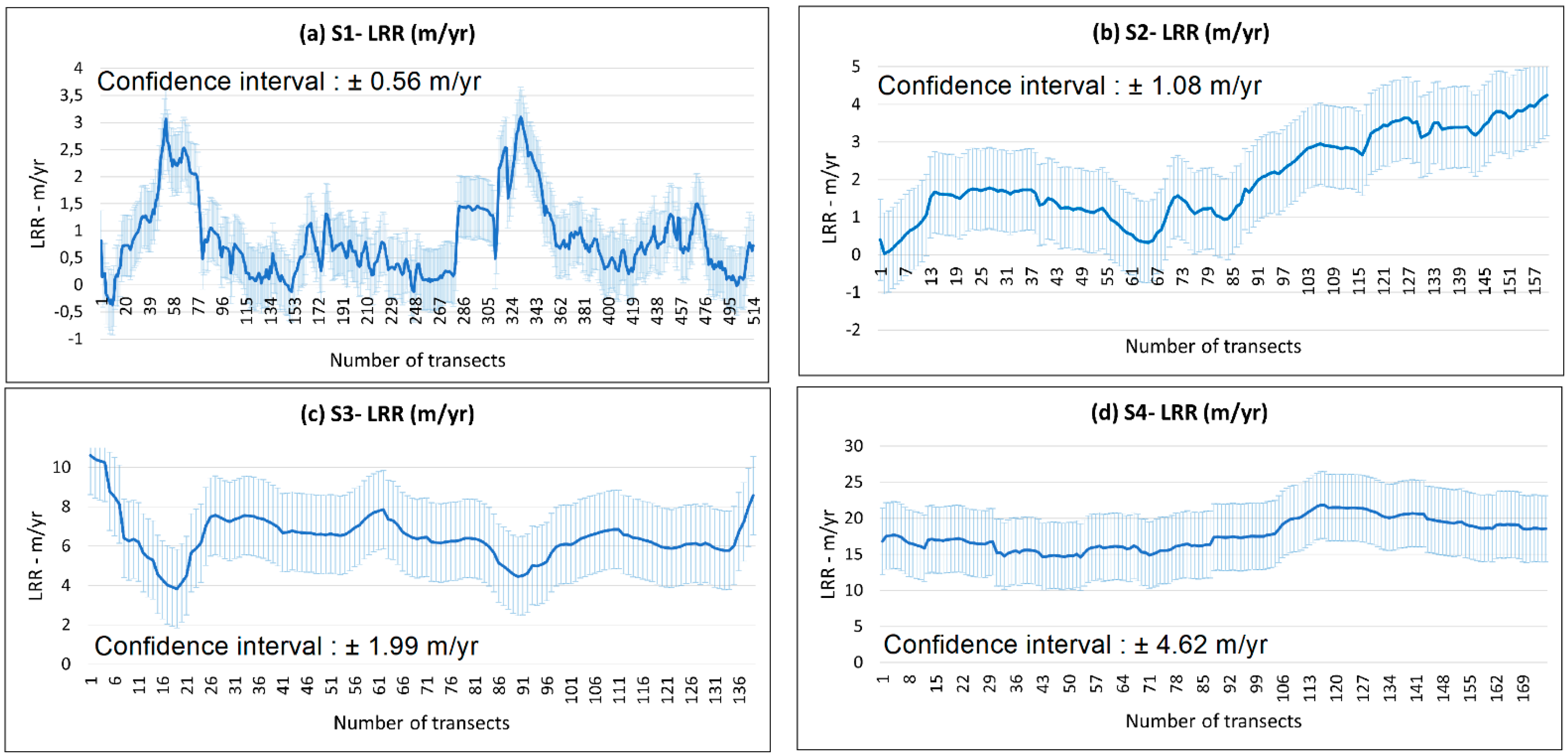
| Baseline Sectors (S)/Length | S1 (5.14 km) | S2 (1.60 km) | S3 (1.38 km) | S4 (1.75 km) |
|---|---|---|---|---|
| Number of transects | 514 | 160 | 139 | 175 |
| Mean LRR (m/year) | 0.85 | 2.06 | 6.46 | 17.75 |
| Mean LCI | 0.56 | 1.08 | 1.99 | 4.62 |
| Parameter | April 2021 | August 2021 | November 2021 |
|---|---|---|---|
| Water parameters | |||
| Depth (m) | 0.4 ± 0.13 (0.2–0.5) | 0.51 ± 0.03 (0.5–0.6) | 0.51 ± 0.08 (0.4–0.7) |
| Water transparency (m) | 0.22 ± 0.16 (0.1–0.5) | 0.28 ± 0.06 (0.2–0.4) | 0.37 ± 0.08 (0.25–0.5) |
| Temperature (°C) | 16.32 ± 0.64 (15.4–17.2) | 28.07 ± 0.78 (26.9–29.3) | 14.89 ± 0.64 (13.6–15.7) |
| Salinity | 28.52 ± 4.97 (23–37) | 17.75 ± 3.33 (11.87–21.33) | 25.8 ± 2.97 (21.19–30.06) |
| Dissolved Oxygen (mg/L) | 11.76 ± 0.6 (11.02–12.6) | 9.2 ± 4.4 (5.75–19.89) | 7.27 ± 0.57 (6.48–8.07) |
| pH | 8.46 ± 0.09 (8.35–8.61) | 8.42 ± 0.13 (8.24–8.61) | 8.15 ± 0.11 (7.96–8.3) |
| TOC (mg/L) | 3.02 ± 2.11 (0.57–5.88) | 9.07 ± 1.41 (6.67–11.57) | 4.8 ± 1.45 (2.84–7.52) |
| TN (mg/L) | 0.38 ± 0.2 (0.05–0.65) | 0.76 ± 0.18 (0.44–1.08) | 0.32 ± 0.05 (0.26–0.41) |
| Phosphates (mg/L) | 0.06 ± 0.02 (0.05–0.1) | 0.11 ± 0.04 (0.07–0.17) | 0.16 ± 0.25 (0.05–0.68) |
| Nitrate (mg/L) | 0.25 ± 0.04 (0.23–0.32) | 0.29 ± 0.08 (0.23–0.44) | 0.23 ± 0 (0.23–0.23) |
| Nitrite (mg/L) | 0.01 ± 0 (0.01–0.01) | 0.06 ± 0.05 (0.01–0.19) | 0.01 ± 0 (0.01–0.01) |
| Ammonium (mg/L) | 0.01 ± 0 (0.01–0.01) | 0.09 ± 0.03 (0.01–0.14) | 0.01 ± 0 (0.01–0.01) |
| Sediment parameters | |||
| TOC (%) | 1.32 ± 0.26 (1.16–1.82) | 1.58 ± 0.18 (1.27–1.81) | 0.67 ± 0.12 (0.5–0.91) |
| TN (mg/g) | 0.92 ± 0.22 (0.71–1.33) | 1.05 ± 0.21 (0.76–1.37) | 0.44 ± 0.13 (0.28–0.64) |
| TP (mg/g) | 0.42 ± 0.06 (0.34–0.5) | 0.37 ± 0.05 (0.26–0.43) | 0.49 ± 0.11 (0.35–0.78) |
| Ecological and diversity indices | |||
| Species richness | 6.33 ± 1.21 (5–8) | 4 ± 1.41 (1–5) | 5.75 ± 1.6 (3–8) |
| Individuals/m2 | 3286.67 ±
2694.16 (1520–8640) | 4213.33 ±
3744.54 (680–10640) | 8876.67 ±
8216.57 (1400–25120) |
| Shannon-Wiener index | 1.29 ± 0.48 (0.53–1.82) | 0.92 ± 0.58 (0–1.96) | 1.25 ± 0.74 (0.32–2.21) |
| Pielou’s evenness index | 0.48 ± 0.15 (0.23–0.61) | 0.49 ± 0.21 (0.18–0.84) | 0.49 ± 0.25 (0.16–0.88) |
| M-AMBI | 0.19 ± 0.06 (0.1–0.27) | 0.15 ± 0.06 (0.06–0.25) | 0.2 ± 0.1 (0.06–0.35) |
| Ecological status | Poor | Poor | Poor |
Disclaimer/Publisher’s Note: The statements, opinions and data contained in all publications are solely those of the individual author(s) and contributor(s) and not of MDPI and/or the editor(s). MDPI and/or the editor(s) disclaim responsibility for any injury to people or property resulting from any ideas, methods, instructions or products referred to in the content. |
© 2023 by the authors. Licensee MDPI, Basel, Switzerland. This article is an open access article distributed under the terms and conditions of the Creative Commons Attribution (CC BY) license (https://creativecommons.org/licenses/by/4.0/).
Share and Cite
Apostolopoulos, D.N.; Giannikopoulos, D.; Ramfos, A.; Faulwetter, S.; Panagiotaras, D.; Nikolakopoulos, K.G.; Avramidis, P. Monitoring the Kotychi Lagoon in Western Peloponnese, Greece, Using Remote Sensing Techniques and Environmental Assessment. J. Mar. Sci. Eng. 2023, 11, 411. https://doi.org/10.3390/jmse11020411
Apostolopoulos DN, Giannikopoulos D, Ramfos A, Faulwetter S, Panagiotaras D, Nikolakopoulos KG, Avramidis P. Monitoring the Kotychi Lagoon in Western Peloponnese, Greece, Using Remote Sensing Techniques and Environmental Assessment. Journal of Marine Science and Engineering. 2023; 11(2):411. https://doi.org/10.3390/jmse11020411
Chicago/Turabian StyleApostolopoulos, Dionysios N., Dionysios Giannikopoulos, Alexis Ramfos, Sara Faulwetter, Dionisios Panagiotaras, Konstantinos G. Nikolakopoulos, and Pavlos Avramidis. 2023. "Monitoring the Kotychi Lagoon in Western Peloponnese, Greece, Using Remote Sensing Techniques and Environmental Assessment" Journal of Marine Science and Engineering 11, no. 2: 411. https://doi.org/10.3390/jmse11020411
APA StyleApostolopoulos, D. N., Giannikopoulos, D., Ramfos, A., Faulwetter, S., Panagiotaras, D., Nikolakopoulos, K. G., & Avramidis, P. (2023). Monitoring the Kotychi Lagoon in Western Peloponnese, Greece, Using Remote Sensing Techniques and Environmental Assessment. Journal of Marine Science and Engineering, 11(2), 411. https://doi.org/10.3390/jmse11020411