Cities and Infrastructure

A topical collection in Buildings (ISSN 2075-5309). This collection belongs to the section "Construction Management, and Computers & Digitization".

Viewed by 63857

Editors


E-Mail Website
Collection Editor
City Futures Research Centre, School of Built Environment, University of New South Wales, Kensington, Sydney, NSW 2052, Australia
Interests: sensing technologies; AI; machine learning; advanced GIS; BIM; digital twins; city analytics methods; digital construction; smart cities; smart construction
Special Issues, Collections and Topics in MDPI journals

E-Mail Website
Collection Editor
City Planning, City Planning Discipline, School of Architecture and Built Environment, Faculty of Built Environment, The University of New South Wales, Sydney, NSW 2052, Australia
Interests: transport planning; travel behaviour; smart transport; machine learning applications

E-Mail Website
Collection Editor
School of Built Environment, University of New South Wales (UNSW), Sydney, NSW 2052, Australia
Interests: BIM; ICT applications in construction industry; digital twins; construction sustainability; women in construction; construction health and safety
Special Issues, Collections and Topics in MDPI journals

Topical Collection Information

Dear Colleagues,

This Topical Collection is interdisciplinary and intends to cover a wide range of issues related to our cities and infrastructure. Rapid urbanisation and the advancement of digital technologies provide opportunities to transform cities into smarter, more sustainable and resilient environments. Sustainable development goals (SDGs) provide directions for making cities “inclusive, safe, resilient and sustainable” (SDG No. 11) and building “resilient infrastructure, [that] promote[s] inclusive and sustainable industrialization and foster innovation” (SDG No. 9).

This Topical Collection seeks papers, reports, and review articles that present novel tools, advanced methodologies, or case studies devoted to bridging the gaps between the theory and practices in cities and infrastructure development and SDGs.

COVID-19 has presented significant changes and challenges in the ways we live, communicate, carry out tasks in cities, and develop our infrastructure projects. In this Topical Collection, we are also keen to share the lessons learnt from adopting digital technologies in managing and planning cities and infrastructure, and the applied analytics on city and infrastructure data before and during the pandemic, which provide better insights on the changes of patterns and activities during this extraordinary period.

Potential topics for this Topical Collection include but are not limited to cities, transport, construction challenges, application of digital technologies and information systems such as GIS, BIM, digital twin, visualisation methods, machine learning, computer vision, sensing technologies, big geospatial data management for improving smart cities, and other management topics related to cities and infrastructure and the spatiotemporal changes of cities during COVID-19.

Dr. Sara Shirowzhan
Dr. Brian Lee
Dr. Cynthia Changxin Wang
Collection Editors

Manuscript Submission Information

Manuscripts should be submitted online at www.mdpi.com by registering and logging in to this website. Once you are registered, click here to go to the submission form. Manuscripts can be submitted until the deadline. All submissions that pass pre-check are peer-reviewed. Accepted papers will be published continuously in the journal (as soon as accepted) and will be listed together on the collection website. Research articles, review articles as well as short communications are invited. For planned papers, a title and short abstract (about 100 words) can be sent to the Editorial Office for announcement on this website.

Submitted manuscripts should not have been published previously, nor be under consideration for publication elsewhere (except conference proceedings papers). All manuscripts are thoroughly refereed through a single-blind peer-review process. A guide for authors and other relevant information for submission of manuscripts is available on the Instructions for Authors page. Buildings is an international peer-reviewed open access monthly journal published by MDPI.

Please visit the Instructions for Authors page before submitting a manuscript. The Article Processing Charge (APC) for publication in this open access journal is 2600 CHF (Swiss Francs). Submitted papers should be well formatted and use good English. Authors may use MDPI's English editing service prior to publication or during author revisions.

Keywords

  • BIM and GIS applications
  • sustainable development goals
  • construction management
  • infrastructure management
  • city planning
  • transport planning
  • city and building analytics
  • advances in digital technologies for the built environment
  • machine learning applications
  • digital twins and Internet of Things
  • built environment—challenges and trends
  • spatiotemporal changes and analysis
  • COVID-19—disruptions and effects

Published Papers (16 papers)

2024

Jump to: 2023, 2022, 2021

20 pages, 7364 KiB  
Article
Deep-Learning-Based Automated Building Information Modeling Reconstruction Using Orthophotos with Digital Surface Models
by Dejiang Wang, Quanming Jiang and Jinzheng Liu
Buildings 2024, 14(3), 808; https://doi.org/10.3390/buildings14030808 - 15 Mar 2024
Viewed by 1336
Abstract
In the field of building information modeling (BIM), converting existing buildings into BIM by using orthophotos with digital surface models (DSMs) is a critical technical challenge. Currently, the BIM reconstruction process is hampered by the inadequate accuracy of building boundary extraction when carried [...] Read more.
In the field of building information modeling (BIM), converting existing buildings into BIM by using orthophotos with digital surface models (DSMs) is a critical technical challenge. Currently, the BIM reconstruction process is hampered by the inadequate accuracy of building boundary extraction when carried out using existing technology, leading to insufficient correctness in the final BIM reconstruction. To address this issue, this study proposes a novel deep-learning- and postprocessing-based approach to automating reconstruction in BIM by using orthophotos with DSMs. This approach aims to improve the efficiency and correctness of the reconstruction of existing buildings in BIM. The experimental results in the publicly available Tianjin and Urban 3D reconstruction datasets showed that this method was able to extract accurate and regularized building boundaries, and the correctness of the reconstructed BIM was 85.61% and 82.93%, respectively. This study improved the technique of extracting regularized building boundaries from orthophotos and DSMs and achieved significant results in enhancing the correctness of BIM reconstruction. These improvements are helpful for the reconstruction of existing buildings in BIM, and this study provides a solid foundation for future improvements to the algorithm. Full article
Show Figures

Figure 1

2023

Jump to: 2024, 2022, 2021

14 pages, 4628 KiB  
Article
Make TOD More Bicycling-Friendly: An Extended Node-Place Model Incorporating a Cycling Accessibility Index
by Mengyuan Zhang and Jinwoo (Brian) Lee
Buildings 2023, 13(5), 1240; https://doi.org/10.3390/buildings13051240 - 9 May 2023
Cited by 3 | Viewed by 1992
Abstract
Building cities more sustainably through transit-oriented development (TOD) has become a principal planning concept in recent decades. The node-place model serves as an important tool for determining the TOD typology, combining the consideration of the station with the transport network in which it [...] Read more.
Building cities more sustainably through transit-oriented development (TOD) has become a principal planning concept in recent decades. The node-place model serves as an important tool for determining the TOD typology, combining the consideration of the station with the transport network in which it is located. A number of studies have proposed the addition of new indicators to the original node-place model. However, the importance of bicycling as a mode of transport to access the transport mode, and within the vicinity of TODs, has been overlooked in the literature. In this paper, two bicycling-related indicators are added to the extended node-place model using Burwood Station in Sydney, Australia, as a case study. The results of the analysis show that the introduction of bicycle accessibility-related factors significantly impacts the TOD typology, and particularly the design index of the extended node-place model. This result implies that only considering pedestrian-related indicators may cause certain deviations in terms of the modelling result. The study highlights the significance of considering bicycling infrastructure in TOD planning to promote the use of active travel and sustainable transport behaviour. Full article
Show Figures

Figure 1

2022

Jump to: 2024, 2023, 2021

16 pages, 1064 KiB  
Article
The COVID-19 Sentiment and Office Markets: Evidence from China
by Shizhen Wang, Chyi Lin Lee and Yan Song
Buildings 2022, 12(12), 2100; https://doi.org/10.3390/buildings12122100 - 30 Nov 2022
Cited by 11 | Viewed by 3055
Abstract
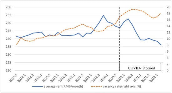
This study examines the impact of COVID-19 sentiment on office building rents and vacancy rates in China with a COVID-19 sentiment index constructed based on Baidu search queries on COVID-19-related keywords. We analyzed the data of office buildings and economic data from 2013 [...] Read more.
This study examines the impact of COVID-19 sentiment on office building rents and vacancy rates in China with a COVID-19 sentiment index constructed based on Baidu search queries on COVID-19-related keywords. We analyzed the data of office buildings and economic data from 2013 Q3 to 2022 Q2 in seven major Chinese cities with a two-stage Error Correction Model framework. We found that a heightened level of COVID-19 sentiment significantly and adversely affects the Chinese office buildings market. Specifically, office building rents decrease more than 8% if a city is exposed to an increase of one unit of COVID-19 sentiment for an entire quarter. The interaction terms model further reveals that the COVID-19 sentiment has a more substantial impact on office building rents where office vacancy is higher, reflecting an asymmetric effect. The findings here support the fear sentiment hypothesis. The findings suggest that a heightened level of investors’ COVID-19 sentiment resulted in a deterioration of office rents, reinforcing the role of investors’ sentiment in the pricing of office buildings. The findings suggest that investors should consider investor sentiment, particularly COVID-19 sentiment, in their decision-making. Full article
Show Figures

Figure 1

22 pages, 2727 KiB  
Article
A Bayesian Approach towards Modelling the Interrelationships of Pavement Deterioration Factors
by Babitha Philip and Hamad Al Jassmi
Buildings 2022, 12(7), 1039; https://doi.org/10.3390/buildings12071039 - 18 Jul 2022
Cited by 3 | Viewed by 2181
Abstract
In this study, Bayesian Belief Networks (BBN) are proposed to model the relationships between factors contributing to pavement deterioration, where their values are probabilistically estimated based on their interdependencies. Such probabilistic inferences are deemed to provide a reasonable alternative over costly data collection [...] Read more.
In this study, Bayesian Belief Networks (BBN) are proposed to model the relationships between factors contributing to pavement deterioration, where their values are probabilistically estimated based on their interdependencies. Such probabilistic inferences are deemed to provide a reasonable alternative over costly data collection campaigns and assist in road condition diagnoses and assessment efforts in cases where data are only partially available. The BBN models examined in this study are based on a vast database of pavement deterioration factors including road distress data, namely cracking, deflection, the International Roughness Index (IRI) and rutting, from major road sections in the United Arab Emirates (UAE) along with the corresponding traffic and climatic factors. The dataset for the analysis consisted of 3272 road sections, each of 10 m length. The test results showed that the most critical parameter representing the whole process of road deterioration is the IRI with the highest nodal force. Additionally, IRI is strongly correlated with rutting and deflection, with mutual information of 0.147 and 0.143, respectively. Furthermore, a Bayesian network structure with a contingency table fit of over 90% illustrates how the road distress parameters change in the presence of external factors, such as traffic and climatic conditions. Full article
Show Figures

Figure 1

26 pages, 15486 KiB  
Article
Sustainability Assessment through Urban Accessibility Indicators and GIS in a Middle-Sized World Heritage City: The Case of Cáceres, Spain
by Montaña Jiménez-Espada, Aurora Cuartero and Maguelone Le Breton
Buildings 2022, 12(6), 813; https://doi.org/10.3390/buildings12060813 - 13 Jun 2022
Cited by 10 | Viewed by 3362
Abstract
The main objective of the research consists of quantifying the degree of sustainability of the city of Cáceres in terms of the inhabitant’s accessibility to public services through the use of GIS tools and urban indicators, taking into account two areas of study: [...] Read more.
The main objective of the research consists of quantifying the degree of sustainability of the city of Cáceres in terms of the inhabitant’s accessibility to public services through the use of GIS tools and urban indicators, taking into account two areas of study: The Historic Centre (PCH) and the city as a whole. The methodology applied is based on the criteria proposed by the Spanish Government derived from the Spanish Strategy for Urban and Local Sustainability (EESUL), which suggests suitable indicators for analysing urban environments. The degree of sustainability of the study areas, applied to the field of mobility and accessibility to public services, is evaluated through numerical calculations complementing the study with accessibility maps obtained using Geographic Information Systems (GIS) tools. The results show that the city of Cáceres is sustainable in terms of accessibility to bus stops, organic waste containers, household waste recycling centre, schools and education, health centres, and public administration. However, bike parking coverage and lanes, clothes and oil collection, and sports centres need to be further enhanced. In conclusion, there is little disparity in the results between the PCH and the city as a whole, not influenced by the fact that one of the areas is a consolidated historic area. This research has allowed some gaps in the topic to be addressed. However, the main limitation of this methodology consists in the need to have a considerable amount of initial starting data to be able to carry out the research. Finally, the sustainability analysis using urban indicators is considered a valuable source of information for the local manager, becoming a real planning tool in medium-sized cities. Full article
Show Figures

Figure 1

22 pages, 1099 KiB  
Article
A Three-Dimensional Evaluation Model of the Externalities of Highway Infrastructures to Capture the Temporal and Spatial Distance to Optimal—A Case Study of China
by Lei Zhu, Lina Zhang, Qianwen Ye, Jing Du and Xianbo Zhao
Buildings 2022, 12(3), 328; https://doi.org/10.3390/buildings12030328 - 9 Mar 2022
Cited by 5 | Viewed by 3564
Abstract
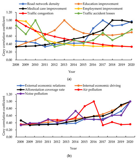
Various externalities caused by highway infrastructures, such as promoting economic development, traffic congestion, and air pollution, are becoming more and more important. Currently, there is no multi-dimensional quantitative evaluation of the externalities of highway infrastructures, hindering the sustainable planning and development of highway [...] Read more.
Various externalities caused by highway infrastructures, such as promoting economic development, traffic congestion, and air pollution, are becoming more and more important. Currently, there is no multi-dimensional quantitative evaluation of the externalities of highway infrastructures, hindering the sustainable planning and development of highway infrastructures. Therefore, this study aims to develop a three-dimensional evaluation model of the externalities of highway infrastructures. To achieve the above objective, this study: (1) developed a three-dimensional evaluation index system through a comprehensive literature review and interviews with experts; (2) weighted the evaluation indexes using the entropy weight method; (3) developed the comprehensive evaluation model using the grey correlation analysis method; (4) validated the developed model by using statistical data of Jiangsu province, China. The analysis results showed that the developed model is feasible and effective in evaluating the externalities of highway infrastructures as the analysis results are consistent with reality. In addition, the model can capture the value of externality-related information, the distance to the optimal state of the externalities of highway infrastructures, and the temporal and spatial trends of the externalities of highway infrastructures for a region. The results of this study for the first time set a basis for investigating the influential mechanism of the multi-dimensional externalities of highway infrastructures. Moreover, the results provide theoretical support for the scientific formulation of relevant policies and decision-making for the government. Full article
Show Figures

Figure 1

17 pages, 1850 KiB  
Article
Construction Theory for a Building Intelligent Operation and Maintenance System Based on Digital Twins and Machine Learning
by Yuhong Zhao, Naiqiang Wang, Zhansheng Liu and Enyi Mu
Buildings 2022, 12(2), 87; https://doi.org/10.3390/buildings12020087 - 18 Jan 2022
Cited by 43 | Viewed by 5505
Abstract
The operation and maintenance (O&M) of buildings plays an important role in ensuring that the buildings work normally, as well as reducing the damage caused by functional errors. There are obvious problems in the traditional O&M modality, and an effective way to solve [...] Read more.
The operation and maintenance (O&M) of buildings plays an important role in ensuring that the buildings work normally, as well as reducing the damage caused by functional errors. There are obvious problems in the traditional O&M modality, and an effective way to solve them is to make the model smarter. In this paper, a digital twin framework for building operation is proposed, which consists of two key components: a digital twin O&M model and a machine learning algorithm. The process of establishing the digital twin model is introduced in detail, and the method is explained according to the structure, equipment, and energy consumption characteristics of the model. A mechanism of fusing the digital twin and machine learning algorithm is proposed and the prediction process based on an artificial neural network (ANN) is shown. Finally, based on a systematic summary of the modeling process and fusion mechanism, the development path and overall structure of the intelligent O&M system utilizing digital twins is proposed. Full article
Show Figures

Figure 1

42 pages, 23273 KiB  
Article
Lockout, Lockdown and Land Use: Exploring the Spatio-Temporal Evolution Patterns of Licensed Venues in Sydney, Australia between 2012 and 2021 in the Context of NSW Public Policy
by Jayden Mitchell Perry, Sara Shirowzhan and Christopher James Pettit
Buildings 2022, 12(1), 35; https://doi.org/10.3390/buildings12010035 - 2 Jan 2022
Viewed by 4983
Abstract
The hospitality industry in Sydney, Australia, has been subject to several regulatory interventions in the last decade, including lockout laws, COVID-19 lockdowns and land use planning restrictions. This study has sought to explore the spatial implications of these policies in Inner Sydney between [...] Read more.
The hospitality industry in Sydney, Australia, has been subject to several regulatory interventions in the last decade, including lockout laws, COVID-19 lockdowns and land use planning restrictions. This study has sought to explore the spatial implications of these policies in Inner Sydney between 2012 to 2021. Methods based in spatial analysis were applied to a database of over 40,000 licensed venues. Point pattern analysis and spatial autocorrelation methods were used to identify spatially significant venue clusters. Space-time cube and emerging-hot-spot methods were used to explore clusters over time. The results indicate that most venues are located in the Sydney CBD on business-zoned land and show a high degree of spatial clustering. Spatio-temporal analysis reveals this clustering to be consistent over time, with variations between venue types. Venue numbers declined following the introduction of the lockout laws, with numbers steadily recovering in the following years. There was no discernible change in the number of venues following the COVID-19 lockdowns; however, economic data suggest that there has been a decline in revenue. Some venues were identified as having temporarily ceased trading, with these clustered in the Sydney CBD. The findings of this study provide a data-driven approach to assist policymakers and industry bodies in better understanding the spatial implications of policies targeting the hospitality sector and will assist with recovery following the COVID-19 pandemic. Further research utilising similar methods could assess the impacts of further COVID-19 lockdowns as experienced in Sydney in 2021. Full article
Show Figures

Figure 1

2021

Jump to: 2024, 2023, 2022

37 pages, 22784 KiB  
Article
The Impact of Increased Density on Residential Property Values in Sydney, New South Wales
by Narvaez Sodhi, Sara Shirowzhan and Samad Sepasgozar
Buildings 2021, 11(12), 650; https://doi.org/10.3390/buildings11120650 - 14 Dec 2021
Cited by 3 | Viewed by 5407
Abstract
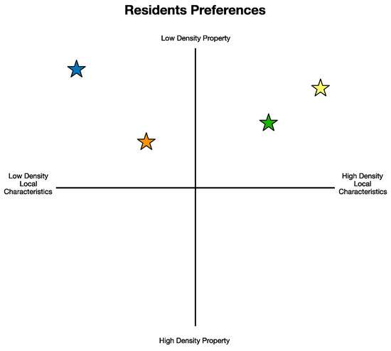
This paper investigates the impact of high-density development on low-density residential property values in Sydney, New South Wales (NSW). To do so, it conducts a literature review to ascertain the existing knowledge surrounding the study of property valuation and its economic and societal [...] Read more.
This paper investigates the impact of high-density development on low-density residential property values in Sydney, New South Wales (NSW). To do so, it conducts a literature review to ascertain the existing knowledge surrounding the study of property valuation and its economic and societal implications. Limitations within academia were identified and addressed as the objectives of this research. Subsequently, the key objective of this research is to “study the sociological factors dictating the attractiveness of low-density (LD) properties within proximity to high-density (HD) local characteristics.” In addressing this objective, research questions explore the interactions of an area’s local characteristics, its residents’ property types and the perceptions surrounding these interactions. This research studies property value through the lens of market perceptions, as the price of land is a basic indicator of the attractiveness, economic value and amenities accessible to a specific site. Through this seminal understanding, the research methodology was formed in which a questionnaire was completed by Sydney residents, providing data for analysis and discussion. The primary research question determines that “low-density residents perceive high-density local characteristics to be attractive”. Through this determination and its associated discussion, this study proposes that ‘if high-density local characteristics are able to be utilised by low-density properties, low-density residents will consider these properties to be more valuable’. Full article
Show Figures

Figure 1

12 pages, 958 KiB  
Article
Exploring Socio-Demographic and Urban Form Indices in Demand Forecasting Models to Reflect Spatial Variations: Case Study of Childcare Centres in Hobart, Australia
by Amir Mousavi, Jonathan Bunker and Jinwoo (Brian) Lee
Buildings 2021, 11(10), 493; https://doi.org/10.3390/buildings11100493 - 19 Oct 2021
Cited by 1 | Viewed by 1968
Abstract
This study investigated whether indices for socioeconomic, demographic and urban form characteristics can reflect the overall effect of each category in a demand forecasting model. Regression equations were developed for trip generation of the land use of long day care centres (LDCC) in [...] Read more.
This study investigated whether indices for socioeconomic, demographic and urban form characteristics can reflect the overall effect of each category in a demand forecasting model. Regression equations were developed for trip generation of the land use of long day care centres (LDCC) in the metropolitan region of Hobart, Australia, to estimate the morning peak hourly private car trip generation of the centres. The independent variables for the model were functions of socioeconomic, demographic and urban form related indices, while the dependent variable was private car trip generation per number of staff or children. Findings show that using indices for socioeconomic, demographic and urban form characteristics enhances overall model performance, while the models based on the commonly used method for estimating trip generation present acceptable results in just some specific sites. The use of socioeconomic, demographic and urban form indices can reflect differences in these characteristics across suburbs when estimating trip generation. Full article
Show Figures

Figure 1

15 pages, 680 KiB  
Article
Towards an Integrated Approach to Infrastructure Damage Assessment in the Aftermath of Natural Hazards
by Madhav Prasad Nepal, Carol Hon, Jinwoo (Brian) Lee and Ziru Xiang
Buildings 2021, 11(10), 450; https://doi.org/10.3390/buildings11100450 - 1 Oct 2021
Cited by 5 | Viewed by 2900
Abstract
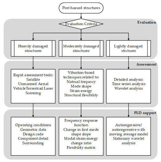
The world has witnessed an alarmingly increasing number of serious natural hazards. In the aftermath of a hazard, relevant authorities/agencies face, among others, the challenging tasks of rapidly evaluating and assessing the damages to infrastructures and restoring their essential functionality and operation. The [...] Read more.
The world has witnessed an alarmingly increasing number of serious natural hazards. In the aftermath of a hazard, relevant authorities/agencies face, among others, the challenging tasks of rapidly evaluating and assessing the damages to infrastructures and restoring their essential functionality and operation. The availability of reliable, high-quality structural and operational/maintenance data of a structure and its health, before and after a natural hazard, can be instrumental in the rapid assessment of a damaged structure. We collectively refer, in this paper, to the existing as-built and facility operational information about a structure or an infrastructure asset represented respectively in Building Information Modeling (BIM) and Infrastructure Asset Management (IAM) systems as Product Lifecycle Data (PLD). Arguably, PLD combined with other post-hazard condition assessment data can provide a more reliable and integrated solution for a rapid damage assessment of buildings and other critical infrastructures. Unfortunately, the application of PLD in this critical area has been unexplored in the literature, and the mapping between PLD and damage assessment methods is loosely investigated. In an effort to address this research gap, this paper provides a critical analysis of the most common structural damage assessment methods and explores the potential of combining them with PLD to provide more reliable, comprehensive, and integrated solution for damage assessment. Findings from this study could be useful for practitioners in selecting the most appropriate and effective methods to conduct damage and safety assessments of critical infrastructures. The study will also assist the further theoretical developments in the integration of PLD with different damage assessment methods. Full article
Show Figures

Figure 1

23 pages, 1051 KiB  
Article
Promoting Health and Safety in Construction through the Procurement Process
by Elijah Frimpong Boadu, Riza Yosia Sunindijo and Cynthia Changxin Wang
Buildings 2021, 11(10), 437; https://doi.org/10.3390/buildings11100437 - 27 Sep 2021
Cited by 3 | Viewed by 3759
Abstract
This study explored the impact of considering health and safety (H&S) in the construction procurement process based on the extent of H&S implementation on projects. Underpinned by information integration and rational decision-making theories, the study evaluated how the integration of H&S objectives into [...] Read more.
This study explored the impact of considering health and safety (H&S) in the construction procurement process based on the extent of H&S implementation on projects. Underpinned by information integration and rational decision-making theories, the study evaluated how the integration of H&S objectives into the overall project objectives, and the subsequent consideration of H&S matters in procurement decisions, influence H&S implementation on projects. Data were collected using questionnaire surveys from 287 respondents in Ghana who had direct involvement in the project procurement process. The survey explored the extent of H&S integration into the procurement process and its subsequent impact on H&S implementation. Path analysis was carried out to determine the causal relationships between the various procurement processes and H&S implementation. The results demonstrate that setting H&S objectives and integrating H&S into the planning stage decisions have a significant impact on the extent to which H&S matters are considered in the tendering and tender evaluation stages, as well as the H&S provisions in conditions of contracts. It also showed that adequate H&S consideration in these procurement stages subsequently influences H&S consideration in contract administration and monitoring and ultimately influences the extent of H&S implementation. These findings demonstrate the importance of integrating H&S in all aspects of construction procurement to promote H&S implementation on projects. Full article
Show Figures

Figure 1

30 pages, 2459 KiB  
Review
3D Tree Reconstruction in Support of Urban Microclimate Simulation: A Comprehensive Literature Review
by Han Xu, Cynthia Changxin Wang, Xuesong Shen and Sisi Zlatanova
Buildings 2021, 11(9), 417; https://doi.org/10.3390/buildings11090417 - 17 Sep 2021
Cited by 20 | Viewed by 5453
Abstract
The negative climate change induced by rapid urbanization has become a global environmental issue. Numerous studies have been devoted to microclimate regulation functions performed by urban vegetation. Digital city information modeling provides a powerful tool for various simulations and data analytics for the [...] Read more.
The negative climate change induced by rapid urbanization has become a global environmental issue. Numerous studies have been devoted to microclimate regulation functions performed by urban vegetation. Digital city information modeling provides a powerful tool for various simulations and data analytics for the sustainable development of urban areas. However, the method reconstructing urban trees is still in its early stage compared to the relatively mature building modeling. Most prior studies on tree reconstruction focused on retrieving geometric features, while other factors related to urban microclimate simulation were rarely addressed. This paper presents a comprehensive literature review and in-depth analysis covering two distinct research directions in relation to urban microclimate simulation. The first one is set on the identification of key factors related to trees’ impact on urban microclimate. The second one is dedicated to approaches for three-dimensional (3D) tree reconstruction. Based on the findings, the paper identifies information including trees’ geometric, physiological characteristics and relation to the surroundings required for 3D tree reconstruction in the context of urban microclimate simulation, and further assesses the potential of the 3D tree reconstruction approaches to accommodate these pieces of information. An appropriate 3D tree reconstruction approach, which allows for the supply of the required information for urban microclimate simulation, is recommended. Full article
Show Figures

Figure 1

22 pages, 3722 KiB  
Article
Onsite Quality Check for Installation of Prefabricated Wall Panels Using Laser Scanning
by Mudan Wang, Cynthia Changxin Wang, Sisi Zlatanova, Samad Sepasgozar and Mitko Aleksandrov
Buildings 2021, 11(9), 412; https://doi.org/10.3390/buildings11090412 - 16 Sep 2021
Cited by 17 | Viewed by 4528
Abstract
Prefabricated construction has gained increasing popularity to meet the needs of rapid city development in recent years. Installation quality check is a critical task in prefabricated construction, and currently mostly still carried out manually, which is slow and ineffective. To provide an efficient [...] Read more.
Prefabricated construction has gained increasing popularity to meet the needs of rapid city development in recent years. Installation quality check is a critical task in prefabricated construction, and currently mostly still carried out manually, which is slow and ineffective. To provide an efficient and practical quality check method to replace the current manual method, this paper elaborates on an approach for checking prefabricated wall panels using laser scanning. The approach is validated in an actual case study. A common laser scanner BLK 360 is adopted to collect onsite 3D scenes after panel installation. The point clouds collected are co-roistered, classified, and segmented. Geometric parameters such as angles and distances allow for determining whether the installation meets the quality requirement. The outcome is compared with the quality check results using the conventional manual method. The results show that the panels, which need rectification, are correctly identified by the proposed approach. The major contribution of this study is determining the set of segmentation parameters to be adopted in similar quality check-up procedures. A practical and efficient quality check process is also proposed and can be readily implemented for certain prefabricated elements in many construction cases. Full article
Show Figures

Figure 1

22 pages, 4436 KiB  
Review
Industry 4.0, Disaster Risk Management and Infrastructure Resilience: A Systematic Review and Bibliometric Analysis
by Mahyar Habibi Rad, Mohammad Mojtahedi and Michael J. Ostwald
Buildings 2021, 11(9), 411; https://doi.org/10.3390/buildings11090411 - 16 Sep 2021
Cited by 40 | Viewed by 6950
Abstract
The fourth industrial era, known as ‘Industry 4.0’ (I4.0), aided and abetted by the digital revolution, has attracted increasing attention among scholars and practitioners in the last decade. The adoption of I4.0 principles in Disaster Risk Management (DRM) research and associated industry practices [...] Read more.
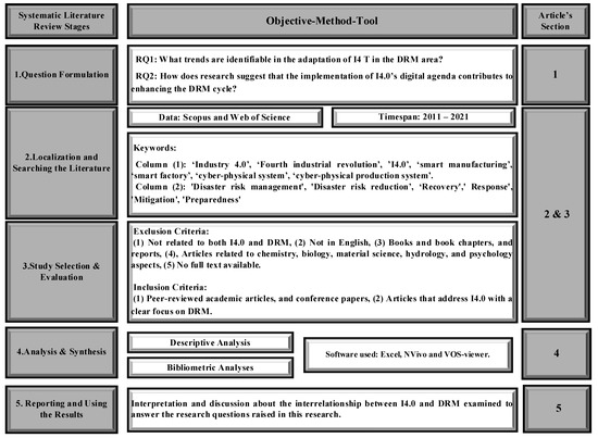
The fourth industrial era, known as ‘Industry 4.0’ (I4.0), aided and abetted by the digital revolution, has attracted increasing attention among scholars and practitioners in the last decade. The adoption of I4.0 principles in Disaster Risk Management (DRM) research and associated industry practices is particularly notable, although its origins, impacts and potential are not well understood. In response to this knowledge gap, this paper conducts a systematic literature review and bibliometric analysis of the application and contribution of I4.0 in DRM. The systematic literature review identified 144 relevant articles and then employed descriptive and content analysis of a focused set of 70 articles published between 2011 and 2021. The results of this review trace the growing trend for adoption of I4.0 tools and techniques in disaster management, and in parallel their influence in resilient infrastructure and digital construction fields. The results are used to identify six dominant clusters of research activity: big data analytics, Internet of Things, prefabrication and modularization, robotics and cyber-physical systems. The research in each cluster is then mapped to the priorities of the Sendai framework for DRR, highlighting the ways it can support this international agenda. Finally, this paper identifies gaps within the literature and discusses possible future research directions for the combination of I4.0 and DRM. Full article
Show Figures

Figure 1

15 pages, 2649 KiB  
Article
Spatiotemporal Changes in Vertical Heterogeneity: High-Rise Office Building Floor Space in Sydney, Australia
by Hoon Han, Haonan Chen and Jinwoo (Brian) Lee
Buildings 2021, 11(8), 374; https://doi.org/10.3390/buildings11080374 - 21 Aug 2021
Cited by 7 | Viewed by 3097
Abstract
Mixed-use development is increasingly popular in land use planning and zoning, fostering a combination of residential, commercial, and cultural uses into one space. However, there is a lack of understanding of the vertical mix office space within a high-rise commercial building and the [...] Read more.
Mixed-use development is increasingly popular in land use planning and zoning, fostering a combination of residential, commercial, and cultural uses into one space. However, there is a lack of understanding of the vertical mix office space within a high-rise commercial building and the dynamics of the industry mix between buildings. This paper examines the spatiotemporal patterns of industry mix between and within office buildings in Sydney CBD from 2006 to 2017, using the data obtained from the City of Sydney floor space and employment surveys. This is the first study that identifies the dynamics of an industrial ecosystem in central Sydney, which has transformed to homophily land blocks, with increasing vertically heterogeneous office buildings, over the past decade. In addition, the study found that the significant clustering of anchor tenants, such as finances, hospitalities, and knowledge-based industries, are apparent. Full article
Show Figures

Figure 1

Back to TopTop