remotesensing-logo

Journal Browser

Journal Browser

Feature Papers for Section Environmental Remote Sensing

A topical collection in Remote Sensing (ISSN 2072-4292). This collection belongs to the section "Environmental Remote Sensing".

Viewed by 170267

Editor

Topical Collection Information

Dear Colleagues,

Growing concerns about the human impact on the environment has led to the development of new observation and analysis tools to tackle and monitor the types, magnitudes, and rates of environmental changes. Timely observations by Earth observation (EO) satellite systems, and improved mapping and analysis tools are enabling a better understanding of the ecological and environmental interactions that underlie our Earth systems, which is critical for developing sustainable solutions. The section on environmental remote sensing deals with emerging methods, technologies, and high-impact EO applications in real-world contexts. It may include sensors such as a synthetic aperture radar for coastal subsidence monitoring, UAV-based disaster damage and recovery assessment, high resolution multispectral data for ecosystem vulnerability and rehabilitation assessment, or hyperspectral data for biodiversity mapping and analysis. Topics may cover a broad range of environments, from coastal to forest and desert areas, as well as applications, for example, conservation management, land conversion, natural resources mapping, and ecosystem dynamics. The focus of this Special Issue is on environmental issues in light of climate change and human impacts. Manuscripts for this important Special Issue of Remote Sensing will be accepted by the editorial office, the Editor-in-Chief and editorial board members by invitation only.

  • Ecosystem assessment and monitoring;
  • Land-use/-cover changes (LUCC);
  • Arid land geomorphology;
  • Water resources assessment;
  • Wetland and coastal dynamics;
  • Geohazards;
  • Land subsidence;
  • Subsurface investigation;
  • Time-series analysis;
  • Data fusion and assimilation;
  • Synergy of optical and radar;
  • New sensors/platforms applications

Dr. Magaly Koch
Collection Editor

Manuscript Submission Information

Manuscripts should be submitted online at www.mdpi.com by registering and logging in to this website. Once you are registered, click here to go to the submission form. Manuscripts can be submitted until the deadline. All submissions that pass pre-check are peer-reviewed. Accepted papers will be published continuously in the journal (as soon as accepted) and will be listed together on the collection website. Research articles, review articles as well as short communications are invited. For planned papers, a title and short abstract (about 100 words) can be sent to the Editorial Office for announcement on this website.

Submitted manuscripts should not have been published previously, nor be under consideration for publication elsewhere (except conference proceedings papers). All manuscripts are thoroughly refereed through a single-blind peer-review process. A guide for authors and other relevant information for submission of manuscripts is available on the Instructions for Authors page. Remote Sensing is an international peer-reviewed open access semimonthly journal published by MDPI.

Please visit the Instructions for Authors page before submitting a manuscript. The Article Processing Charge (APC) for publication in this open access journal is 2700 CHF (Swiss Francs). Submitted papers should be well formatted and use good English. Authors may use MDPI's English editing service prior to publication or during author revisions.

Published Papers (29 papers)

2024

Jump to: 2022, 2021, 2020, 2019

30 pages, 5364 KiB  
Article
Characterizing Chromophoric Dissolved Organic Matter Spatio-Temporal Variability in North Andean Patagonian Lakes Using Remote Sensing Information and Environmental Analysis
by Ayelén Sánchez Valdivia, Lucia G. De Stefano, Gisela Ferraro, Diamela Gianello, Anabella Ferral, Ana I. Dogliotti, Mariana Reissig, Marina Gerea, Claudia Queimaliños and Gonzalo L. Pérez
Remote Sens. 2024, 16(21), 4063; https://doi.org/10.3390/rs16214063 - 31 Oct 2024
Viewed by 651
Abstract
Chromophoric dissolved organic matter (CDOM) is crucial in aquatic ecosystems, influencing light penetration and biogeochemical processes. This study investigates the CDOM variability in seven oligotrophic lakes of North Andean Patagonia using Landsat 8 imagery. An empirical band ratio model was calibrated and validated [...] Read more.
Chromophoric dissolved organic matter (CDOM) is crucial in aquatic ecosystems, influencing light penetration and biogeochemical processes. This study investigates the CDOM variability in seven oligotrophic lakes of North Andean Patagonia using Landsat 8 imagery. An empirical band ratio model was calibrated and validated for the estimation of CDOM concentrations in surface lake water as the absorption coefficient at 440 nm (acdom440, m−1). Of the five atmospheric corrections evaluated, the QUAC (Quick Atmospheric Correction) method demonstrated the highest accuracy for the remote estimation of CDOM. The application of separate models for deep and shallow lakes yielded superior results compared to a combined model, with R2 values of 0.76 and 0.82 and mean absolute percentage errors (MAPEs) of 14% and 22% for deep and shallow lakes, respectively. The spatio-temporal variability of CDOM was characterized over a five-year period using satellite-derived acdom440 values. CDOM concentrations varied widely, with very low values in deep lakes and moderate values in shallow lakes. Additionally, significant seasonal fluctuations were evident. Lower CDOM concentrations were observed during the summer to early autumn period, while higher concentrations were observed in the winter to spring period. A gradient boosting regression tree analysis revealed that inter-lake differences were primarily influenced by the lake perimeter to lake area ratio, mean lake depth, and watershed area to lake volume ratio. However, seasonal CDOM variation was largely influenced by Lake Nahuel Huapi water storage (a proxy for water level variability at a regional scale), followed by precipitation, air temperature, and wind. This research presents a robust method for estimating low to moderate CDOM concentrations, improving environmental monitoring of North Andean Patagonian Lake ecosystems. The results deepen the understanding of CDOM dynamics in low-impact lakes and its main environmental drivers, enhance the ability to estimate lacustrine carbon stocks on a regional scale, and help to predict the effects of climate change on this important variable. Full article
Show Figures

Graphical abstract

26 pages, 30702 KiB  
Article
HydroSAR: A Cloud-Based Service for the Monitoring of Inundation Events in the Hindu Kush Himalaya
by Franz J. Meyer, Lori A. Schultz, Batuhan Osmanoglu, Joseph H. Kennedy, MinJeong Jo, Rajesh B. Thapa, Jordan R. Bell, Sudip Pradhan, Manish Shrestha, Jacquelyn Smale, Heidi Kristenson, Brooke Kubby and Thomas J. Meyer
Remote Sens. 2024, 16(17), 3244; https://doi.org/10.3390/rs16173244 - 1 Sep 2024
Viewed by 892
Abstract
The Hindu Kush Himalaya (HKH) is one of the most flood-prone regions in the world, yet heavy cloud cover and limited in situ observations have hampered efforts to monitor the impact of heavy rainfall, flooding, and inundation during severe weather events. This paper [...] Read more.
The Hindu Kush Himalaya (HKH) is one of the most flood-prone regions in the world, yet heavy cloud cover and limited in situ observations have hampered efforts to monitor the impact of heavy rainfall, flooding, and inundation during severe weather events. This paper introduces HydroSAR, a Sentinel-1 SAR-based hazard monitoring service which was co-developed with in-region partners to provide year-round, low-latency weather hazard information across the HKH. This paper describes the end user-focused concept and overall design of the HydroSAR service. It introduces the main processing algorithms behind HydroSAR’s broad product portfolio, which includes qualitative visual layers as well as quantitative products measuring the surface water extent and water depth. We summarize the cloud-based implementation of the developed service, which provides the capability to scale automatically with the event size. A performance assessment of our quantitative algorithms is described, demonstrating the capabilities to map the flood extent and water depth with an accuracy of >90% and <1 m, respectively. An application of the HydroSAR service to the 2023 South Asia monsoon seasons showed that monsoon floods peaked near 6 August 2023 and covered 11.6% of Bangladesh in water. At the peak of the flood season, nearly 13.5% of Bangladesh’s agriculture areas were affected. Full article
Show Figures

Figure 1

23 pages, 28193 KiB  
Article
Using Ground-Penetrating Radar (GPR) to Investigate the Exceptionally Thick Deposits from the Storegga Tsunami in Northeastern Scotland
by Charlie S. Bristow, Lucy K. Buck and Rishi Shah
Remote Sens. 2024, 16(11), 2042; https://doi.org/10.3390/rs16112042 - 6 Jun 2024
Viewed by 1256
Abstract
A submarine landslide on the edge of the Norwegian shelf that occurred around 8150 ± 30 cal. years BP triggered a major ocean-wide tsunami, the deposits of which are recorded around the North Atlantic, including Scotland. Ground-penetrating radar (GPR) was used here to [...] Read more.
A submarine landslide on the edge of the Norwegian shelf that occurred around 8150 ± 30 cal. years BP triggered a major ocean-wide tsunami, the deposits of which are recorded around the North Atlantic, including Scotland. Ground-penetrating radar (GPR) was used here to investigate tsunami sediments within estuaries on the coast of northeastern Scotland where the tsunami waves were funnelled inland. Around the Dornoch Firth, the tsunami deposits are up to 1.6 m thickness, which is exceptionally thick for tsunami deposits and about twice the thickness of the 2004 IOT or 2011 Tohoku-oki tsunami deposits. The exceptional thickness is attributed to a high sediment supply within the Dornoch Firth. At Ardmore, the tsunami appears to have overtopped a beach ridge with a thick sand layer deposited inland at Dounie and partly infilled a valley. Later, fluvial activity eroded the tsunami sediments locally, removing the sand layer. At Creich, on the north side of the Dornoch Firth, the sand layer varies in thickness; mapping of the sand layer with GPR shows lateral thickness changes of over 1 m attributed to a combination of infilling an underlying topography, differential compaction, and later reworking by tidal inlets. Interpretation of the GPR profiles at Wick suggests that there has been a miscorrelation of Holocene stratigraphy based on boreholes. Changes in the stratigraphy of spits at Ardmore are attributed to the balance between sediment supply and sea-level change with washovers dominating a spit formed during the early Holocene transgression, while spits formed during the subsequent mid-Holocene high-stand are dominated by progradation. Full article
Show Figures

Graphical abstract

29 pages, 12712 KiB  
Article
Evaluating Tropical Cyclone-Induced Flood and Surge Risks for Vanuatu by Assessing Location Hazard Susceptibility
by Cameron Do, Yuriy Kuleshov, Suelynn Choy and Chayn Sun
Remote Sens. 2024, 16(11), 1890; https://doi.org/10.3390/rs16111890 - 24 May 2024
Viewed by 954
Abstract
Tropical cyclones (TCs) can be devastating events for vulnerable countries like Vanuatu, impacting their population, livelihoods, and infrastructure, leaving the country in need of aid and recovery. Despite this, comprehensive risk information on the nuanced impacts of each region is not well understood. [...] Read more.
Tropical cyclones (TCs) can be devastating events for vulnerable countries like Vanuatu, impacting their population, livelihoods, and infrastructure, leaving the country in need of aid and recovery. Despite this, comprehensive risk information on the nuanced impacts of each region is not well understood. Every TC event is different, and understanding the potential for impact at each location empowers decision makers in the lead-up to an event or during off-season planning to make more informed decisions to direct disaster risk reduction efforts. TC hazard model data typically describe intensity and likelihood, which can be fed into risk assessment frameworks to describe probabilistic risk. This study instead uses freely available remote sensing data to create proxies for the TC hazards of storm surge and flooding and to describe only the intensity of the hazard if the event occurs at the location. This hazard susceptibility index is fed into a risk assessment framework with Vanuatu exposure and vulnerability data for domains of populations, housing, and roads. These methods allow for the risk to be estimated for each month, as well as during specific historical time periods of TC Pam, TC Harold, and the TCs Judy and Kevin, enabling future impact validation. The results show households to have the highest risk, followed by roads and population domains, while a TC-induced surge risk is overall higher than TC-induced flooding, particularly in the road domain. The results, however, show a likely underestimation of event hazards and an overestimation of Port Vila’s resistance to impacts, which is a subject of future investigation and validation. Full article
Show Figures

Graphical abstract

2022

Jump to: 2024, 2021, 2020, 2019

21 pages, 26337 KiB  
Communication
War Related Building Damage Assessment in Kyiv, Ukraine, Using Sentinel-1 Radar and Sentinel-2 Optical Images
by Yusupujiang Aimaiti, Christina Sanon, Magaly Koch, Laurie G. Baise and Babak Moaveni
Remote Sens. 2022, 14(24), 6239; https://doi.org/10.3390/rs14246239 - 9 Dec 2022
Cited by 22 | Viewed by 7531
Abstract
Natural and anthropogenic disasters can cause significant damage to urban infrastructure, landscape, and loss of human life. Satellite based remote sensing plays a key role in rapid damage assessment, post-disaster reconnaissance and recovery. In this study, we aim to assess the performance of [...] Read more.
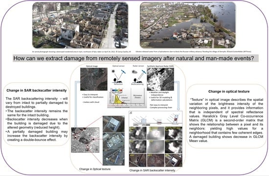
Natural and anthropogenic disasters can cause significant damage to urban infrastructure, landscape, and loss of human life. Satellite based remote sensing plays a key role in rapid damage assessment, post-disaster reconnaissance and recovery. In this study, we aim to assess the performance of Sentinel-1 and Sentinel-2 data for building damage assessment in Kyiv, the capital city of Ukraine, due to the ongoing war with Russia. For damage assessment, we employ a simple and robust SAR log ratio of intensity for the Sentinel-1, and a texture analysis for the Sentinel-2. To suppress changes from other features and landcover types not related to urban areas, we construct a mask of the built-up area using the OpenStreetMap building footprints and World Settlement Footprint (WSF), respectively. As it is difficult to get ground truth data in the ongoing war zone, a qualitative accuracy assessment with the very high-resolution optical images and a quantitative assessment with the United Nations Satellite Center (UNOSAT) damage assessment map was conducted. The results indicated that the damaged buildings are mainly concentrated in the northwestern part of the study area, wherein Irpin, and the neighboring towns of Bucha and Hostomel are located. The detected building damages show a good match with the reference WorldView images. Compared with the damage assessment map by UNOSAT, 58% of the damaged buildings were correctly classified. The results of this study highlight the potential offered by publicly available medium resolution satellite imagery for rapid mapping damage to provide initial reference data immediately after a disaster. Full article
Show Figures

Graphical abstract

2021

Jump to: 2024, 2022, 2020, 2019

16 pages, 48284 KiB  
Article
Detecting Demolished Buildings after a Natural Hazard Using High Resolution RGB Satellite Imagery and Modified U-Net Convolutional Neural Networks
by Vahid Rashidian, Laurie G. Baise, Magaly Koch and Babak Moaveni
Remote Sens. 2021, 13(11), 2176; https://doi.org/10.3390/rs13112176 - 2 Jun 2021
Cited by 7 | Viewed by 5211
Abstract
Collapsed buildings are usually linked with the highest number of human casualties reported after a natural disaster; therefore, quickly finding collapsed buildings can expedite rescue operations and save human lives. Recently, many researchers and agencies have tried to integrate satellite imagery into rapid [...] Read more.
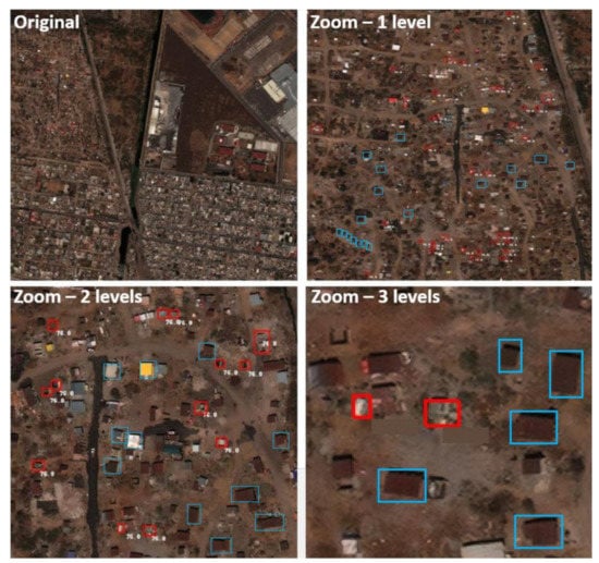
Collapsed buildings are usually linked with the highest number of human casualties reported after a natural disaster; therefore, quickly finding collapsed buildings can expedite rescue operations and save human lives. Recently, many researchers and agencies have tried to integrate satellite imagery into rapid response. The U.S. Defense Innovation Unit Experimental (DIUx) and National Geospatial Intelligence Agency (NGA) have recently released a ready-to-use dataset known as xView that contains thousands of labeled VHR RGB satellite imagery scenes with 30-cm spatial and 8-bit radiometric resolutions, respectively. Two of the labeled classes represent demolished buildings with 1067 instances and intact buildings with more than 300,000 instances, and both classes are associated with building footprints. In this study, we are using the xView imagery, with building labels (demolished and intact) to create a deep learning framework for classifying buildings as demolished or intact after a natural hazard event. We have used a modified U-Net style fully convolutional neural network (CNN). The results show that the proposed framework has 78% and 95% sensitivity in detecting the demolished and intact buildings, respectively, within the xView dataset. We have also tested the transferability and performance of the trained network on an independent dataset from the 19 September 2017 M 7.1 Pueblo earthquake in central Mexico using Google Earth imagery. To this end, we tested the network on 97 buildings including 10 demolished ones by feeding imagery and building footprints into the trained algorithm. The sensitivity for intact and demolished buildings was 89% and 60%, respectively. Full article
Show Figures

Figure 1

14 pages, 1779 KiB  
Article
Covariation of Passive–Active Microwave Measurements over Vegetated Surfaces: Case Studies at L-Band Passive and L-, C- and X-Band Active
by Erica Albanesi, Silvia Bernoldi, Fabio Dell’Acqua and Dara Entekhabi
Remote Sens. 2021, 13(9), 1786; https://doi.org/10.3390/rs13091786 - 4 May 2021
Cited by 3 | Viewed by 2459
Abstract
The analysis of soil and land cover scattering properties and their connection with the parameters of microwave scattering is a longstanding research topic. Recently, the advent of modern space-borne microwave radiometers like SMAP in addition to the trend towards open data for scientific [...] Read more.
The analysis of soil and land cover scattering properties and their connection with the parameters of microwave scattering is a longstanding research topic. Recently, the advent of modern space-borne microwave radiometers like SMAP in addition to the trend towards open data for scientific use fostered the development of enhanced models based on data fusion from different platforms permitting more accurate assessments. SMAP was designed to operate on an integrated combination of a radiometer and a radar, both operating in L-band. Unexpected failure of the radar component encouraged scientists to experiment various combination of data from the surviving radiometer with other sources of radar data, notably C-band Sentinel-1 data. In this work, we present a case study on a possible combination of SMAP radiometer data with X-band radar data from TerraSAR-X and COSMO-SkyMed, comparing results with those provided by NASA from their standard production procedures. The study was performed on two test sites, one at an agricultural site in Germany and one in the Brazilian Amazon, to explore very different vegetation conditions. This work is a part of a broader research effort addressing the combination of multiple sources of passive and active microwave sensing data. The research question defining this research effort is whether the use of data from multiple active sources affords either obtaining more accurate estimates of active–passive co-variation parameters for a given observation period, or shortening the minimum observation period by increasing the temporal density of active samples. In this framework, this paper addresses a preliminary comparison of fresh and past results obtained from C-, X-, and L-band active sensing data. The observed relations offer interesting clues on the impact of band selection on soil vegetation analysis. Full article
Show Figures

Graphical abstract

18 pages, 2679 KiB  
Article
Satellite Monitoring of Environmental Solar Ultraviolet A (UVA) Exposure and Irradiance: A Review of OMI and GOME-2
by Alfio V. Parisi, Damien Igoe, Nathan J. Downs, Joanna Turner, Abdurazaq Amar and Mustapha A. A Jebar
Remote Sens. 2021, 13(4), 752; https://doi.org/10.3390/rs13040752 - 18 Feb 2021
Cited by 13 | Viewed by 3504
Abstract
Excessive exposure to solar ultraviolet (UV) radiation has damaging effects on life on Earth. High-energy short-wavelength ultraviolet B (UVB) is biologically effective, influencing a range of dermal processes, including the potentially beneficial production of vitamin D. In addition to the damaging effects of [...] Read more.
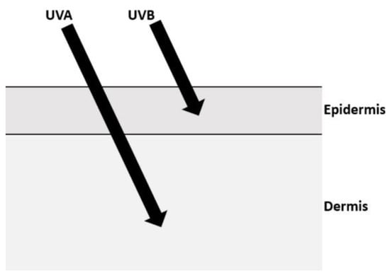
Excessive exposure to solar ultraviolet (UV) radiation has damaging effects on life on Earth. High-energy short-wavelength ultraviolet B (UVB) is biologically effective, influencing a range of dermal processes, including the potentially beneficial production of vitamin D. In addition to the damaging effects of UVB, the longer wavelength and more abundant ultraviolet A (UVA) has been shown to be linked to an increased risk of skin cancer. To evaluate this risk requires the monitoring of the solar UVA globally on a time repetitive basis in order to provide an understanding of the environmental solar UVA irradiance and resulting exposures that humans may receive during their normal daily activities. Satellite-based platforms, with the appropriate validation against ground-based instrumentation, can provide global monitoring of the solar UVA environment. Two satellite platforms that currently provide data on the terrestrial UVA environment are the ozone monitoring instrument (OMI) and the global ozone monitoring experiment (GOME-2). The objectives of this review are to provide a summary of the OMI and GOME-2 satellite-based platforms for monitoring the terrestrial UVA environment and to compare the remotely sensed UVA data from these platforms to that from ground-based instrumentation. Full article
Show Figures

Figure 1

24 pages, 25645 KiB  
Article
Inundation Assessment of the 2019 Typhoon Hagibis in Japan Using Multi-Temporal Sentinel-1 Intensity Images
by Wen Liu, Kiho Fujii, Yoshihisa Maruyama and Fumio Yamazaki
Remote Sens. 2021, 13(4), 639; https://doi.org/10.3390/rs13040639 - 10 Feb 2021
Cited by 11 | Viewed by 3651
Abstract
Typhoon Hagibis passed through Japan on October 12, 2019, bringing heavy rainfall over half of Japan. Twelve banks of seven state-managed rivers collapsed, flooding a wide area. Quick and accurate damage proximity maps are helpful for emergency responses and relief activities after such [...] Read more.
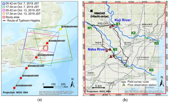
Typhoon Hagibis passed through Japan on October 12, 2019, bringing heavy rainfall over half of Japan. Twelve banks of seven state-managed rivers collapsed, flooding a wide area. Quick and accurate damage proximity maps are helpful for emergency responses and relief activities after such disasters. In this study, we propose a quick analysis procedure to estimate inundations due to Typhoon Hagibis using multi-temporal Sentinel-1 SAR intensity images. The study area was Ibaraki Prefecture, Japan, including two flooded state-managed rivers, Naka and Kuji. First, the completely flooded areas were detected by two traditional methods, the change detection and the thresholding methods. By comparing the results in a part of the affected area with our field survey, the change detection was adopted due to its higher recall accuracy. Then, a new index combining the average value and the standard deviation of the differences was proposed for extracting partially flooded built-up areas. Finally, inundation maps were created by merging the completely and partially flooded areas. The final inundation map was evaluated via comparison with the flooding boundary produced by the Geospatial Information Authority (GSI) and the Ministry of Land, Infrastructure, Transport, and Tourism (MLIT) of Japan. As a result, 74% of the inundated areas were able to be identified successfully using the proposed quick procedure. Full article
Show Figures

Figure 1

28 pages, 25053 KiB  
Article
Multi-Temporal Small Baseline Interferometric SAR Algorithms: Error Budget and Theoretical Performance
by Antonio Pepe
Remote Sens. 2021, 13(4), 557; https://doi.org/10.3390/rs13040557 - 4 Feb 2021
Cited by 17 | Viewed by 4220
Abstract
Multi-temporal interferometric synthetic aperture radar (MT-InSAR) techniques are well recognized as useful tools for detecting and monitoring Earth’s surface temporal changes. In this work, the fundamentals of error noise propagation and perturbation theories are applied to derive the ground displacement products’ theoretical error [...] Read more.
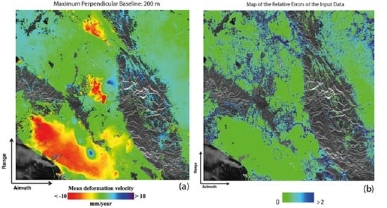
Multi-temporal interferometric synthetic aperture radar (MT-InSAR) techniques are well recognized as useful tools for detecting and monitoring Earth’s surface temporal changes. In this work, the fundamentals of error noise propagation and perturbation theories are applied to derive the ground displacement products’ theoretical error bounds of the small baseline (SB) differential interferometric synthetic aperture radar algorithms. A general formulation of the least-squares (LS) optimization problem, representing the SB methods implementation’s core, was adopted in this research study. A particular emphasis was placed on the effects of time-uncorrelated phase unwrapping mistakes and time-inconsistent phase disturbances in sets of SB interferograms, leading to artefacts in the attainable InSAR products. Moreover, this study created the theoretical basis for further developments aimed at quantifying the error budget of the time-uncorrelated phase unwrapping mistakes and studying time-inconsistent phase artefacts for the generation of InSAR data products. Some experiments, performed by considering a sequence of synthetic aperture radar (SAR) images collected by the ASAR sensor onboard the ENVISAT satellite, supported the developed theoretical framework. Full article
Show Figures

Graphical abstract

2020

Jump to: 2024, 2022, 2021, 2019

25 pages, 11656 KiB  
Article
Semantic Segmentation Deep Learning for Extracting Surface Mine Extents from Historic Topographic Maps
by Aaron E. Maxwell, Michelle S. Bester, Luis A. Guillen, Christopher A. Ramezan, Dennis J. Carpinello, Yiting Fan, Faith M. Hartley, Shannon M. Maynard and Jaimee L. Pyron
Remote Sens. 2020, 12(24), 4145; https://doi.org/10.3390/rs12244145 - 18 Dec 2020
Cited by 33 | Viewed by 6592
Abstract
Historic topographic maps, which are georeferenced and made publicly available by the United States Geological Survey (USGS) and the National Map’s Historical Topographic Map Collection (HTMC), are a valuable source of historic land cover and land use (LCLU) information that could be used [...] Read more.
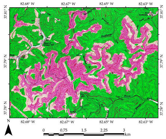
Historic topographic maps, which are georeferenced and made publicly available by the United States Geological Survey (USGS) and the National Map’s Historical Topographic Map Collection (HTMC), are a valuable source of historic land cover and land use (LCLU) information that could be used to expand the historic record when combined with data from moderate spatial resolution Earth observation missions. This is especially true for landscape disturbances that have a long and complex historic record, such as surface coal mining in the Appalachian region of the eastern United States. In this study, we investigate this specific mapping problem using modified UNet semantic segmentation deep learning (DL), which is based on convolutional neural networks (CNNs), and a large example dataset of historic surface mine disturbance extents from the USGS Geology, Geophysics, and Geochemistry Science Center (GGGSC). The primary objectives of this study are to (1) evaluate model generalization to new geographic extents and topographic maps and (2) to assess the impact of training sample size, or the number of manually interpreted topographic maps, on model performance. Using data from the state of Kentucky, our findings suggest that DL semantic segmentation can detect surface mine disturbance features from topographic maps with a high level of accuracy (Dice coefficient = 0.902) and relatively balanced omission and commission error rates (Precision = 0.891, Recall = 0.917). When the model is applied to new topographic maps in Ohio and Virginia to assess generalization, model performance decreases; however, performance is still strong (Ohio Dice coefficient = 0.837 and Virginia Dice coefficient = 0.763). Further, when reducing the number of topographic maps used to derive training image chips from 84 to 15, model performance was only slightly reduced, suggesting that models that generalize well to new data and geographic extents may not require a large training set. We suggest the incorporation of DL semantic segmentation methods into applied workflows to decrease manual digitizing labor requirements and call for additional research associated with applying semantic segmentation methods to alternative cartographic representations to supplement research focused on multispectral image analysis and classification. Full article
Show Figures

Figure 1

15 pages, 9248 KiB  
Article
Deriving Annual Double-Season Cropland Phenology Using Landsat Imagery
by Tong Qiu, Conghe Song and Junxiang Li
Remote Sens. 2020, 12(20), 3275; https://doi.org/10.3390/rs12203275 - 9 Oct 2020
Cited by 11 | Viewed by 4000
Abstract
Cropland phenology provides key information in managing agricultural practices and modelling crop yield. However, most of the existing phenological products have coarse spatial resolution ranging from 250 to 8000 m, which is not sufficient to capture the critical spatial details of cropland phenology [...] Read more.
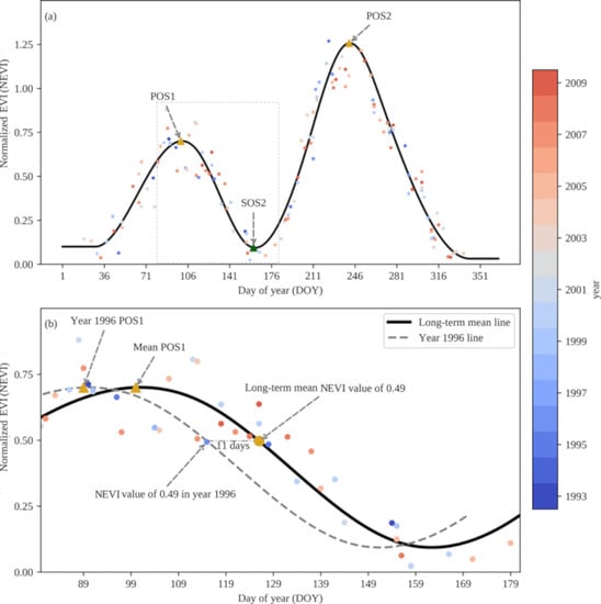
Cropland phenology provides key information in managing agricultural practices and modelling crop yield. However, most of the existing phenological products have coarse spatial resolution ranging from 250 to 8000 m, which is not sufficient to capture the critical spatial details of cropland phenology at the landscape scale. Landsat imagery provides an unprecedented data source to generate 30-m spatial resolution phenological products. This paper explored the potential of utilizing multi-year Landsat enhanced vegetation index to derive annual phenological metrics of a double-season agricultural land from 1993 to 2009 in a sub-urban area of Shanghai, China. We used all available Landsat TM and ETM+ observations (538 scenes) and developed a Landsat double-cropping phenology (LDCP) algorithm. LDCP captures the temporal trajectory of multi-year enhanced vegetation index time series very well, with the degree of fitness ranging from 0.78 to 0.88 over the study regions. We found good agreements between derived annual phenological metrics and in situ observation, with root mean square error ranging from 8.74 to 18.04 days, indicating that the proposed LDCP is capable of detecting double-season cropland phenology. LDCP could reveal the spatial heterogeneity of cropland phenology at parcel scales. Phenology metrics were retrieved for approximately one-third and two-thirds of the 17 years for the first and second cropping cycles, respectively, depending on the number of good quality Landsat data. In addition, we found an advanced peak of season for both cropping cycles in 50–60% of the study area, and a delayed start of season for the second cropping cycle in 50–70% of the same area. The potential drivers of those trends might be climate warming and changes in agricultural practices. The derived cropland phenology can be used to help estimate historical crop yields at Landsat spatial resolution, providing insights on evaluating the effects of climate change on temporal variations of crop growth, and contributing to food security policy making. Full article
Show Figures

Graphical abstract

22 pages, 7381 KiB  
Article
A Google Earth Engine Tool to Investigate, Map and Monitor Volcanic Thermal Anomalies at Global Scale by Means of Mid-High Spatial Resolution Satellite Data
by Nicola Genzano, Nicola Pergola and Francesco Marchese
Remote Sens. 2020, 12(19), 3232; https://doi.org/10.3390/rs12193232 - 4 Oct 2020
Cited by 38 | Viewed by 8658
Abstract
Several satellite-based systems have been developed over the years to study and monitor thermal volcanic activity. Most of them use high temporal resolution satellite data, provided by sensors like the Moderate Resolution Imaging Spectroradiometer (MODIS) that if on the one hand guarantee a [...] Read more.
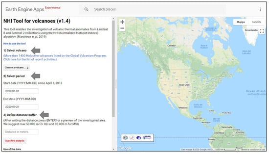
Several satellite-based systems have been developed over the years to study and monitor thermal volcanic activity. Most of them use high temporal resolution satellite data, provided by sensors like the Moderate Resolution Imaging Spectroradiometer (MODIS) that if on the one hand guarantee a continuous monitoring of active volcanic areas on the other hand are less suited to map thermal anomalies, and to provide accurate information about their features. The Multispectral Instrument (MSI) and the Operational Land Imager (OLI), respectively, onboard the Sentinel-2 and Landsat-8 satellites, providing Short-Wave Infrared (SWIR) data at 20 m (MSI) and 30 m (OLI) spatial resolution, may make an important contribution in this area. In this work, we present the first Google Earth Engine (GEE) App to investigate, map and monitor volcanic thermal anomalies at global scale, integrating Landsat-8 OLI and Sentinel-2 MSI observations. This open tool, which implements the Normalized Hot spot Indices (NHI) algorithm, enables the analysis of more than 1400 active volcanoes, with very low processing times, thanks to the high GEE computational resources. Performance and limitations of the tool, such as its next upgrades, aiming at increasing the user-friendly experience and extending the temporal range of data analyses, are analyzed and discussed. Full article
Show Figures

Figure 1

32 pages, 3051 KiB  
Review
Global Monitoring of the Vegetation Dynamics from the Vegetation Optical Depth (VOD): A Review
by Frédéric Frappart, Jean-Pierre Wigneron, Xiaojun Li, Xiangzhuo Liu, Amen Al-Yaari, Lei Fan, Mengjia Wang, Christophe Moisy, Erwan Le Masson, Zacharie Aoulad Lafkih, Clément Vallé, Bertrand Ygorra and Nicolas Baghdadi
Remote Sens. 2020, 12(18), 2915; https://doi.org/10.3390/rs12182915 - 8 Sep 2020
Cited by 105 | Viewed by 12408
Abstract
Vegetation is a key element in the energy, water and carbon balances over the land surfaces and is strongly impacted by climate change and anthropogenic effects. Remotely sensed observations are commonly used for the monitoring of vegetation dynamics and its temporal changes from [...] Read more.
Vegetation is a key element in the energy, water and carbon balances over the land surfaces and is strongly impacted by climate change and anthropogenic effects. Remotely sensed observations are commonly used for the monitoring of vegetation dynamics and its temporal changes from regional to global scales. Among the different indices derived from Earth observation satellites to study the vegetation, the vegetation optical depth (VOD), which is related to the intensity of extinction effects within the vegetation canopy layer in the microwave domain and which can be derived from both passive and active microwave observations, is increasingly used for monitoring a wide range of ecological vegetation variables. Based on different frequency bands used to derive VOD, from L- to Ka-bands, these variables include, among others, the vegetation water content/status and the above ground biomass. In this review, the theoretical bases of VOD estimates for both the passive and active microwave domains are presented and the global long-term VOD products computed from various groups in the world are described. Then, major findings obtained using VOD are reviewed and the perspectives offered by methodological improvements and by new sensors onboard satellite missions recently launched or to be launched in a close future are presented. Full article
Show Figures

Figure 1

20 pages, 6208 KiB  
Article
Arctic Sea Level Budget Assessment during the GRACE/Argo Time Period
by Roshin P. Raj, Ole B. Andersen, Johnny A. Johannessen, Benjamin D. Gutknecht, Sourav Chatterjee, Stine K. Rose, Antonio Bonaduce, Martin Horwath, Heidi Ranndal, Kristin Richter, Hindumathi Palanisamy, Carsten A. Ludwigsen, Laurent Bertino, J. Even Ø. Nilsen, Per Knudsen, Anna Hogg, Anny Cazenave and Jérôme Benveniste
Remote Sens. 2020, 12(17), 2837; https://doi.org/10.3390/rs12172837 - 1 Sep 2020
Cited by 17 | Viewed by 6055
Abstract
Sea level change is an important indicator of climate change. Our study focuses on the sea level budget assessment of the Arctic Ocean using: (1) the newly reprocessed satellite altimeter data with major changes in the processing techniques; (2) ocean mass change data [...] Read more.
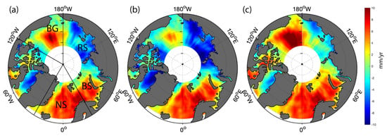
Sea level change is an important indicator of climate change. Our study focuses on the sea level budget assessment of the Arctic Ocean using: (1) the newly reprocessed satellite altimeter data with major changes in the processing techniques; (2) ocean mass change data derived from GRACE satellite gravimetry; (3) and steric height estimated from gridded hydrographic data for the GRACE/Argo time period (2003–2016). The Beaufort Gyre (BG) and the Nordic Seas (NS) regions exhibit the largest positive trend in sea level during the study period. Halosteric sea level change is found to dominate the area averaged sea level trend of BG, while the trend in NS is found to be influenced by halosteric and ocean mass change effects. Temporal variability of sea level in these two regions reveals a significant shift in the trend pattern centered around 2009–2011. Analysis suggests that this shift can be explained by a change in large-scale atmospheric circulation patterns over the Arctic. The sea level budget assessment of the Arctic found a residual trend of more than 1.0 mm/yr. This nonclosure of the sea level budget is further attributed to the limitations of the three above mentioned datasets in the Arctic region. Full article
Show Figures

Figure 1

24 pages, 547 KiB  
Review
Status of Phenological Research Using Sentinel-2 Data: A Review
by Gourav Misra, Fiona Cawkwell and Astrid Wingler
Remote Sens. 2020, 12(17), 2760; https://doi.org/10.3390/rs12172760 - 26 Aug 2020
Cited by 133 | Viewed by 13426
Abstract
Remote sensing of plant phenology as an indicator of climate change and for mapping land cover has received significant scientific interest in the past two decades. The advancing of spring events, the lengthening of the growing season, the shifting of tree lines, the [...] Read more.
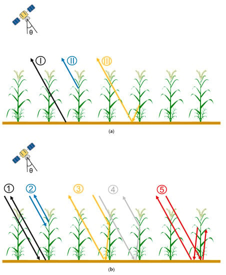
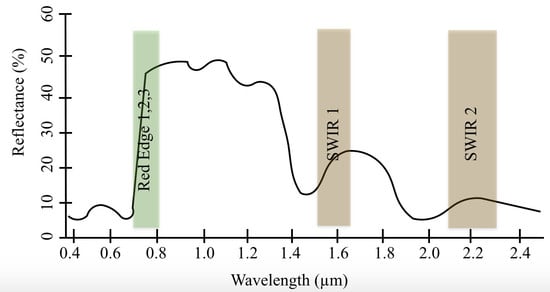
Remote sensing of plant phenology as an indicator of climate change and for mapping land cover has received significant scientific interest in the past two decades. The advancing of spring events, the lengthening of the growing season, the shifting of tree lines, the decreasing sensitivity to warming and the uniformity of spring across elevations are a few of the important indicators of trends in phenology. The Sentinel-2 satellite sensors launched in June 2015 (A) and March 2017 (B), with their high temporal frequency and spatial resolution for improved land mapping missions, have contributed significantly to knowledge on vegetation over the last three years. However, despite the additional red-edge and short wave infra-red (SWIR) bands available on the Sentinel-2 multispectral instruments, with improved vegetation species detection capabilities, there has been very little research on their efficacy to track vegetation cover and its phenology. For example, out of approximately every four papers that analyse normalised difference vegetation index (NDVI) or enhanced vegetation index (EVI) derived from Sentinel-2 imagery, only one mentions either SWIR or the red-edge bands. Despite the short duration that the Sentinel-2 platforms have been operational, they have proved their potential in a wide range of phenological studies of crops, forests, natural grasslands, and other vegetated areas, and in particular through fusion of the data with those from other sensors, e.g., Sentinel-1, Landsat and MODIS. This review paper discusses the current state of vegetation phenology studies based on the first five years of Sentinel-2, their advantages, limitations, and the scope for future developments. Full article
Show Figures

Graphical abstract

23 pages, 6890 KiB  
Article
Using Growing-Season Time Series Coherence for Improved Peatland Mapping: Comparing the Contributions of Sentinel-1 and RADARSAT-2 Coherence in Full and Partial Time Series
by Koreen Millard, Patrick Kirby, Sacha Nandlall, Amir Behnamian, Sarah Banks and Fabrizio Pacini
Remote Sens. 2020, 12(15), 2465; https://doi.org/10.3390/rs12152465 - 31 Jul 2020
Cited by 15 | Viewed by 5460
Abstract
Differences in topographic structure, vegetation structure, and surface wetness exist between peatland classes, making active remote sensing techniques such as SAR and LiDAR promising for peatland mapping. As the timing of green-up, senescence, and hydrologic conditions vary differently in peatland classes, and in [...] Read more.
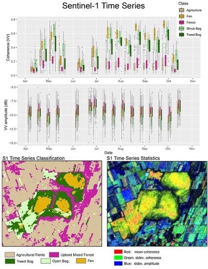
Differences in topographic structure, vegetation structure, and surface wetness exist between peatland classes, making active remote sensing techniques such as SAR and LiDAR promising for peatland mapping. As the timing of green-up, senescence, and hydrologic conditions vary differently in peatland classes, and in comparison with upland classes, full growing-season time series SAR imagery was expected to produce higher accuracy classification results than using only a few select SAR images. Both interferometric coherence, amplitude and difference in amplitude time series datasets were assessed, as it was hypothesized that these may be able to capture subtle changes in phenology and hydrology, which in turn differentiate classes throughout a growing season. Groups of variables were compared for their effectiveness in Random Forest classification for both Sentinel-1 and Radarsat-2. The Shapley value was used to determine the contribution of each group of variables in thirty scenarios, and Mean Decrease in Accuracy was compared to evaluate its ability to rank variables by relative importance. Despite being dual-pol, the results of classifications using Sentinel-1 coherence (12-day repeat) were significantly better than using fully polarimetric RADARSAT-2 coherence (24-day repeat), likely owing to the difference in baseline and specific acquisition dates of the data in this study. Overall, full growing season Sentinel-1 coherence time series produced higher accuracy results than fully polarimetric quad pol RADARSAT-2 coherence amplitude, difference in amplitude and polarimetric decomposition time series. Using a full growing season of time-series imagery in classification resulted in higher accuracy than using a few dates over a growing season. Using mean decrease in accuracy to rank and reduce variables resulted in a weaker classification than if the entire time series is used. Full article
Show Figures

Graphical abstract

19 pages, 24766 KiB  
Article
A Hierarchical Deep-Learning Approach for Rapid Windthrow Detection on PlanetScope and High-Resolution Aerial Image Data
by Wolfgang Deigele, Melanie Brandmeier and Christoph Straub
Remote Sens. 2020, 12(13), 2121; https://doi.org/10.3390/rs12132121 - 2 Jul 2020
Cited by 13 | Viewed by 4704
Abstract
Forest damage due to storms causes economic loss and requires a fast response to prevent further damage such as bark beetle infestations. By using Convolutional Neural Networks (CNNs) in conjunction with a GIS, we aim at completely streamlining the detection and mapping process [...] Read more.
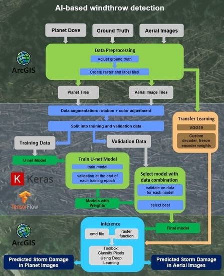
Forest damage due to storms causes economic loss and requires a fast response to prevent further damage such as bark beetle infestations. By using Convolutional Neural Networks (CNNs) in conjunction with a GIS, we aim at completely streamlining the detection and mapping process for forest agencies. We developed and tested different CNNs for rapid windthrow detection based on PlanetScope satellite data and high-resolution aerial image data. Depending on the meteorological situation after the storm, PlanetScope data might be rapidly available due to its high temporal resolution, while the acquisition of high-resolution airborne data often takes weeks to a month and is, therefore, used in a second step for more detailed mapping. The study area is located in Bavaria, Germany (ca. 165 km2), and labels for damaged areas were provided by the Bavarian State Institute of Forestry (LWF). Modifications of a U-Net architecture were compared to other approaches using transfer learning (e.g., VGG19) to find the most efficient architecture for the task on both datasets while keeping the computational time low. A custom implementation of U-Net proved to be more accurate than transfer learning, especially on medium (3 m) resolution PlanetScope imagery (intersection over union score (IoU) 0.55) where transfer learning completely failed. Results for transfer learning based on VGG19 on high-resolution aerial image data are comparable to results from the custom U-Net architecture (IoU 0.76 vs. 0.73). When using both architectures on a dataset from a different area (located in Hesse, Germany), however, we find that the custom implementations have problems generalizing on aerial image data while VGG19 still detects most damage in these images. For PlanetScope data, VGG19 again fails while U-Net achieves reasonable mappings. Results highlight the potential of Deep Learning algorithms to detect damaged areas with an IoU of 0.73 on airborne data and 0.55 on Planet Dove data. The proposed workflow with complete integration into ArcGIS is well-suited for rapid first assessments after a storm event that allows for better planning of the flight campaign followed by detailed mapping in a second stage. Full article
Show Figures

Graphical abstract

38 pages, 11832 KiB  
Article
A New End-to-End Multi-Dimensional CNN Framework for Land Cover/Land Use Change Detection in Multi-Source Remote Sensing Datasets
by Seyd Teymoor Seydi, Mahdi Hasanlou and Meisam Amani
Remote Sens. 2020, 12(12), 2010; https://doi.org/10.3390/rs12122010 - 23 Jun 2020
Cited by 92 | Viewed by 7826
Abstract
The diversity of change detection (CD) methods and the limitations in generalizing these techniques using different types of remote sensing datasets over various study areas have been a challenge for CD applications. Additionally, most CD methods have been implemented in two intensive and [...] Read more.
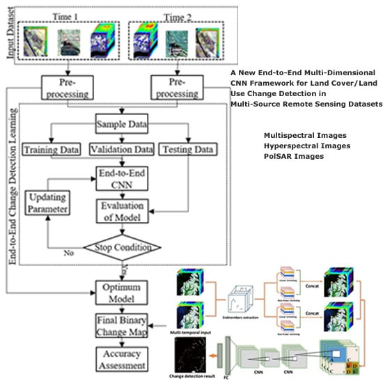
The diversity of change detection (CD) methods and the limitations in generalizing these techniques using different types of remote sensing datasets over various study areas have been a challenge for CD applications. Additionally, most CD methods have been implemented in two intensive and time-consuming steps: (a) predicting change areas, and (b) decision on predicted areas. In this study, a novel CD framework based on the convolutional neural network (CNN) is proposed to not only address the aforementioned problems but also to considerably improve the level of accuracy. The proposed CNN-based CD network contains three parallel channels: the first and second channels, respectively, extract deep features on the original first- and second-time imagery and the third channel focuses on the extraction of change deep features based on differencing and staking deep features. Additionally, each channel includes three types of convolution kernels: 1D-, 2D-, and 3D-dilated-convolution. The effectiveness and reliability of the proposed CD method are evaluated using three different types of remote sensing benchmark datasets (i.e., multispectral, hyperspectral, and Polarimetric Synthetic Aperture RADAR (PolSAR)). The results of the CD maps are also evaluated both visually and statistically by calculating nine different accuracy indices. Moreover, the results of the CD using the proposed method are compared to those of several state-of-the-art CD algorithms. All the results prove that the proposed method outperforms the other remote sensing CD techniques. For instance, considering different scenarios, the Overall Accuracies (OAs) and Kappa Coefficients (KCs) of the proposed CD method are better than 95.89% and 0.805, respectively, and the Miss Detection (MD) and the False Alarm (FA) rates are lower than 12% and 3%, respectively. Full article
Show Figures

Graphical abstract

29 pages, 2934 KiB  
Review
Thermal Remote Sensing from UAVs: A Review on Methods in Coastal Cliffs Prone to Landslides
by Maria Teresa Melis, Stefania Da Pelo, Ivan Erbì, Marco Loche, Giacomo Deiana, Valentino Demurtas, Mattia Alessio Meloni, Francesco Dessì, Antonio Funedda, Marco Scaioni and Gianvito Scaringi
Remote Sens. 2020, 12(12), 1971; https://doi.org/10.3390/rs12121971 - 19 Jun 2020
Cited by 42 | Viewed by 8681
Abstract
Coastal retreat is a non-recoverable phenomenon that—together with a relevant proneness to landslides—has economic, social and environmental impacts. Quantitative data on geological and geomorphologic features of such areas can help to predict and quantify the phenomena and to propose mitigation measures to reduce [...] Read more.
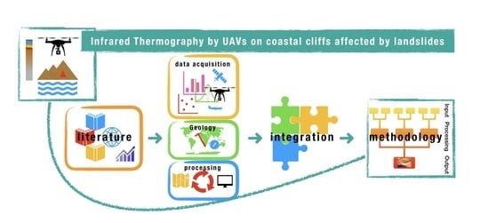
Coastal retreat is a non-recoverable phenomenon that—together with a relevant proneness to landslides—has economic, social and environmental impacts. Quantitative data on geological and geomorphologic features of such areas can help to predict and quantify the phenomena and to propose mitigation measures to reduce their impact. Coastal areas are often inaccessible for sampling and in situ surveys, in particular where steeply sloping cliffs are present. Uses and capability of infrared thermography (IRT) were reviewed, highlighting its suitability in geological and landslides hazard applications. Thanks to the high resolution of the cameras on the market, unmanned aerial vehicle-based IRT allows to acquire large amounts of data from inaccessible steep cliffs. Coupled structure-from-motion photogrammetry and coregistration of data can improve accuracy of IRT data. According to the strengths recognized in the reviewed literature, a three-step methodological approach to produce IRTs was proposed. Full article
Show Figures

Graphical abstract

24 pages, 15989 KiB  
Article
Intertidal Bathymetry Extraction with Multispectral Images: A Logistic Regression Approach
by Isabel Bué, João Catalão and Álvaro Semedo
Remote Sens. 2020, 12(8), 1311; https://doi.org/10.3390/rs12081311 - 21 Apr 2020
Cited by 13 | Viewed by 4607
Abstract
In this study, a methodology to estimate the intertidal bathymetry from multispectral remote sensing images is presented. The technique is based on the temporal variability of the water and the intertidal zone reflectance and their correlation with the tidal height. The water spectral [...] Read more.
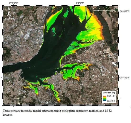
In this study, a methodology to estimate the intertidal bathymetry from multispectral remote sensing images is presented. The technique is based on the temporal variability of the water and the intertidal zone reflectance and their correlation with the tidal height. The water spectral behavior is characterized by high absorption at the infrared (IR) band or radiation with higher wavelengths. Due to tidal cycles, pixels on the intertidal zone have higher temporal variability on the near IR spectral reflectance. The variability of IR reflectivity in time is modeled through a sigmoid function of three parameters, where the inflection parameter corresponds to the pixel elevation. The methodology was tested at the Tagus river estuary in Lisbon, Portugal, and at the Bijagós archipelago, in the West African nation of Guinea-Bissau. Multispectral images from Sentinel-2 satellites were used, after atmospheric corrections from ACOLITE processor and the derived bathymetric model validated with in situ data. The presented method does not require additional depth data for calibration, and the output can generate intertidal digital elevation models at 10 m spatial resolution, without any manual editing by the operator. The results show a standard deviation of 0.34 m at the Tagus tidal zone, with −0.50 m bias, performing better than the Stumpf ratio transform algorithm, also applied to the test areas to derive intertidal bathymetry. This methodology can be used to update intertidal elevation models with clear benefits to monitoring of intertidal dynamics, morphodynamic modeling, and cartographic update. Full article
Show Figures

Graphical abstract

25 pages, 4393 KiB  
Article
Detecting Change in Forest Structure with Simulated GEDI Lidar Waveforms: A Case Study of the Hemlock Woolly Adelgid (HWA; Adelges tsugae) Infestation
by Peter Brehm Boucher, Steven Hancock, David A Orwig, Laura Duncanson, John Armston, Hao Tang, Keith Krause, Bruce Cook, Ian Paynter, Zhan Li, Arthur Elmes and Crystal Schaaf
Remote Sens. 2020, 12(8), 1304; https://doi.org/10.3390/rs12081304 - 20 Apr 2020
Cited by 28 | Viewed by 7908
Abstract
The hemlock woolly adelgid (HWA; Adelges tsugae) is an invasive insect infestation that is spreading into the forests of the northeastern United States, driven by the warmer winter temperatures associated with climate change. The initial stages of this disturbance are difficult to [...] Read more.
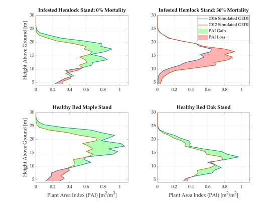
The hemlock woolly adelgid (HWA; Adelges tsugae) is an invasive insect infestation that is spreading into the forests of the northeastern United States, driven by the warmer winter temperatures associated with climate change. The initial stages of this disturbance are difficult to detect with passive optical remote sensing, since the insect often causes its host species, eastern hemlock trees (Tsuga canadensis), to defoliate in the midstory and understory before showing impacts in the overstory. New active remote sensing technologies—such as the recently launched NASA Global Ecosystem Dynamics Investigation (GEDI) spaceborne lidar—can address this limitation by penetrating canopy gaps and recording lower canopy structural changes. This study explores new opportunities for monitoring the HWA infestation with airborne lidar scanning (ALS) and GEDI spaceborne lidar data. GEDI waveforms were simulated using airborne lidar datasets from an HWA-infested forest plot at the Harvard Forest ForestGEO site in central Massachusetts. Two airborne lidar instruments, the NASA G-LiHT and the NEON AOP, overflew the site in 2012 and 2016. GEDI waveforms were simulated from each airborne lidar dataset, and the change in waveform metrics from 2012 to 2016 was compared to field-derived hemlock mortality at the ForestGEO site. Hemlock plots were shown to be undergoing dynamic changes as a result of the HWA infestation, losing substantial plant area in the middle canopy, while still growing in the upper canopy. Changes in midstory plant area (PAI 11–12 m above ground) and overall canopy permeability (indicated by RH10) accounted for 60% of the variation in hemlock mortality in a logistic regression model. The robustness of these structure-condition relationships held even when simulated waveforms were treated as real GEDI data with added noise and sparse spatial coverage. These results show promise for future disturbance monitoring studies with ALS and GEDI lidar data. Full article
Show Figures

Graphical abstract

26 pages, 10931 KiB  
Article
Mapping and Monitoring Small-Scale Mining Activities in Ghana using Sentinel-1 Time Series (2015–2019)
by Gerald Forkuor, Tobias Ullmann and Mario Griesbeck
Remote Sens. 2020, 12(6), 911; https://doi.org/10.3390/rs12060911 - 12 Mar 2020
Cited by 41 | Viewed by 8749
Abstract
Illegal small-scale mining (galamsey) in South-Western Ghana has grown tremendously in the last decade and caused significant environmental degradation. Excessive cloud cover in the area has limited the use of optical remote sensing data to map and monitor the extent of these activities. [...] Read more.
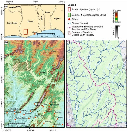
Illegal small-scale mining (galamsey) in South-Western Ghana has grown tremendously in the last decade and caused significant environmental degradation. Excessive cloud cover in the area has limited the use of optical remote sensing data to map and monitor the extent of these activities. This study investigated the use of annual time-series Sentinel-1 data to map and monitor illegal mining activities along major rivers in South-Western Ghana between 2015 and 2019. A change detection approach, based on three time-series features—minimum, mean, maximum—was used to compute a backscatter threshold value suitable to identify/detect mining-induced land cover changes in the study area. Compared to the mean and maximum, the minimum time-series feature (in both VH and VV polarization) was found to be more sensitive to changes in backscattering within the period of investigation. Our approach permitted the detection of new illegal mining areas on an annual basis. A backscatter threshold value of +1.65 dB was found suitable for detecting illegal mining activities in the study area. Application of this threshold revealed illegal mining area extents of 102 km2, 60 km2 and 33 km2 for periods 2015/2016–2016/2017, 2016/2017–2017/2018 and 2017/2018–2018/2019, respectively. The observed decreasing trend in new illegal mining areas suggests that efforts at stopping illegal mining yielded positive results in the period investigated. Despite the advantages of Synthetic Aperture Radar data in monitoring phenomena in cloud-prone areas, our analysis revealed that about 25% of the Sentinel-1 data, mostly acquired in March and October (beginning and end of rainy season respectively), were unusable due to atmospheric effects from high intensity rainfall events. Further investigation in other geographies and climatic regions is needed to ascertain the susceptibility of Sentinel-1 data to atmospheric conditions. Full article
Show Figures

Figure 1

16 pages, 3410 KiB  
Review
Determination of Phycocyanin from Space—A Bibliometric Analysis
by Igor Ogashawara
Remote Sens. 2020, 12(3), 567; https://doi.org/10.3390/rs12030567 - 8 Feb 2020
Cited by 26 | Viewed by 5543
Abstract
Over the past few decades, there has been an increase in the number of studies about the estimation of phycocyanin derived from remote sensing techniques. Since phycocyanin is a unique pigment of inland water cyanobacteria, the quantification of its concentration from earth observation [...] Read more.
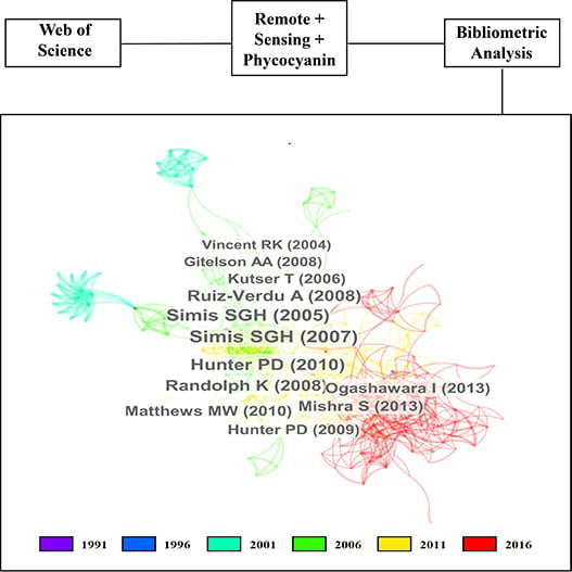
Over the past few decades, there has been an increase in the number of studies about the estimation of phycocyanin derived from remote sensing techniques. Since phycocyanin is a unique pigment of inland water cyanobacteria, the quantification of its concentration from earth observation data is important for water quality monitoring - once some species can produce toxins. Because of the growth of this field in the past decade, several reviews and studies comparing algorithms have been published. Thus, instead of focusing on algorithms comparison or description, the goal of the present study is to systematically analyze and visualize the evolution of publications. Using the Web of Science database this study analyzed the existing publications on remote sensing of phycocyanin decade-by-decade for the period 1991–2020. The bibliometric analysis showed how research topics evolved from measuring pigments to the quantification of optical properties and from laboratory experiments to measuring entire temperate and tropical aquatic systems. This study provides the status quo and development trend of the field and points out what could be the direction for future research. Full article
Show Figures

Graphical abstract

13 pages, 935 KiB  
Article
Multifractal Detrended Cross-Correlation Analysis of Global Methane and Temperature
by Chris G. Tzanis, Ioannis Koutsogiannis, Kostas Philippopoulos and Nikolaos Kalamaras
Remote Sens. 2020, 12(3), 557; https://doi.org/10.3390/rs12030557 - 7 Feb 2020
Cited by 25 | Viewed by 5321
Abstract
Multifractal Detrended Cross-Correlation Analysis (MF-DCCA) was applied to time series of global methane concentrations and remotely-sensed temperature anomalies of the global lower and mid-troposphere, with the purpose of investigating the multifractal characteristics of their cross-correlated time series and examining their interaction in terms [...] Read more.
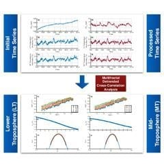
Multifractal Detrended Cross-Correlation Analysis (MF-DCCA) was applied to time series of global methane concentrations and remotely-sensed temperature anomalies of the global lower and mid-troposphere, with the purpose of investigating the multifractal characteristics of their cross-correlated time series and examining their interaction in terms of nonlinear analysis. The findings revealed the multifractal nature of the cross-correlated time series and the existence of positive persistence. It was also found that the cross-correlation in the lower troposphere displayed more abundant multifractal characteristics when compared to the mid-troposphere. The source of multifractality in both cases was found to be mainly the dependence of long-range correlations on different fluctuation magnitudes. Multifractal Detrended Fluctuation Analysis (MF-DFA) was also applied to the time series of global methane and global lower and mid-tropospheric temperature anomalies to separately study their multifractal properties. From the results, it was found that the cross-correlated time series exhibit similar multifractal characteristics to the component time series. This could be another sign of the dynamic interaction between the two climate variables. Full article
Show Figures

Graphical abstract

20 pages, 7171 KiB  
Article
Using High Resolution Optical Imagery to Detect Earthquake-Induced Liquefaction: The 2011 Christchurch Earthquake
by Vahid Rashidian, Laurie G. Baise and Magaly Koch
Remote Sens. 2020, 12(3), 377; https://doi.org/10.3390/rs12030377 - 24 Jan 2020
Cited by 7 | Viewed by 3614
Abstract
Using automated supervised methods with satellite and aerial imageries for liquefaction mapping is a promising step in providing detailed and region-scale maps of liquefaction extent immediately after an earthquake. The accuracy of these methods depends on the quantity and quality of training samples [...] Read more.
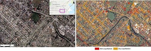
Using automated supervised methods with satellite and aerial imageries for liquefaction mapping is a promising step in providing detailed and region-scale maps of liquefaction extent immediately after an earthquake. The accuracy of these methods depends on the quantity and quality of training samples and the number of available spectral bands. Digitizing a large number of high-quality training samples from an event may not be feasible in the desired timeframe for rapid response as the training pixels for each class should be typical and accurately represent the spectral diversity of that specific class. To perform automated classification for liquefaction detection, we need to understand how to build the optimal and accurate training dataset. Using multispectral optical imagery from the 22 February, 2011 Christchurch earthquake, we investigate the effects of quantity of high-quality training pixel samples as well as the number of spectral bands on the performance of a pixel-based parametric supervised maximum likelihood classifier for liquefaction detection. We find that the liquefaction surface effects are bimodal in terms of spectral signature and therefore, should be classified as either wet liquefaction or dry liquefaction. This is due to the difference in water content between these two modes. Using 5-fold cross-validation method, we evaluate performance of the classifier on datasets with different pixel sizes of 50, 100, 500, 2000, and 4000. Also, the effect of adding spectral information was investigated by adding once only the near infrared (NIR) band to the visible red, green, and blue (RGB) bands and the other time using all available 8 spectral bands of the World-View 2 satellite imagery. We find that the classifier has high accuracies (75%–95%) when using the 2000 pixels-size dataset that includes the RGB+NIR spectral bands and therefore, increasing to 4000 pixels-size dataset and/or eight spectral bands may not be worth the required time and cost. We also investigate accuracies of the classifier when using aerial imagery with same number of training pixels and either RGB or RGB+NIR bands and find that the classifier accuracies are higher when using satellite imagery with same number of training pixels and spectral information. The classifier identifies dry liquefaction with higher user accuracy than wet liquefaction across all evaluated scenarios. To improve classification performance for wet liquefaction detection, we also investigate adding geospatial information of building footprints to improve classification performance. We find that using a building footprint mask to remove them from the classification process, increases wet liquefaction user accuracy by roughly 10%. Full article
Show Figures

Graphical abstract

25 pages, 9694 KiB  
Article
Exploring the Impact of Various Spectral Indices on Land Cover Change Detection Using Change Vector Analysis: A Case Study of Crete Island, Greece
by Christos Polykretis, Manolis G. Grillakis and Dimitrios D. Alexakis
Remote Sens. 2020, 12(2), 319; https://doi.org/10.3390/rs12020319 - 18 Jan 2020
Cited by 58 | Viewed by 6628
Abstract
The main objective of this study was to explore the impact of various spectral indices on the performance of change vector analysis (CVA) for detecting the land cover changes on the island of Crete, Greece, between the last two decades (1999–2009 and 2009–2019). [...] Read more.
The main objective of this study was to explore the impact of various spectral indices on the performance of change vector analysis (CVA) for detecting the land cover changes on the island of Crete, Greece, between the last two decades (1999–2009 and 2009–2019). A set of such indices, namely, normalized difference vegetation index (NDVI), soil adjusted vegetation index (SAVI), albedo, bare soil index (BSI), tasseled cap greenness (TCG), and tasseled cap brightness (TCB), representing both the vegetation and soil conditions of the study area, were estimated on Landsat satellite images captured in 1999, 2009, and 2019. Change vector analysis was then applied for five different index combinations resulting to the relative change outputs. The evaluation of these outputs was performed towards detailed land cover maps produced by supervised classification of the aforementioned images. The results from the two examined periods revealed that the five index combinations provided promising performance results in terms of kappa index (with a range of 0.60–0.69) and overall accuracy (with a range of 0.86–0.96). Moreover, among the different combinations, the use of NDVI and albedo were found to provide superior results against the other combinations. Full article
Show Figures

Graphical abstract

17 pages, 6800 KiB  
Article
Insar Maps of Land Subsidence and Sea Level Scenarios to Quantify the Flood Inundation Risk in Coastal Cities: The Case of Singapore
by Joao Catalao, Durairaju Raju and Giovanni Nico
Remote Sens. 2020, 12(2), 296; https://doi.org/10.3390/rs12020296 - 16 Jan 2020
Cited by 39 | Viewed by 8895
Abstract
Global mean sea level rise associated with global warming has a major impact on coastal areas and represents one of the significant natural hazards. The Asia-Pacific region, which has the highest concentration of human population in the world, represents one of the larger [...] Read more.
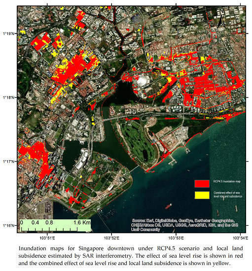
Global mean sea level rise associated with global warming has a major impact on coastal areas and represents one of the significant natural hazards. The Asia-Pacific region, which has the highest concentration of human population in the world, represents one of the larger areas on Earth being threatened by the rise of sea level. Recent studies indicate a global sea level of 3.2 mm/yr as measured from 20 years of satellite altimetry. The combined effect of sea level rise and local land subsidence, can be overwhelming for coastal areas. The Synthetic Aperture Radar (SAR) interferometry technique is used to process a time series of TerraSAR-X images and estimate the land subsidence in the urban area of Singapore. Interferometric SAR (InSAR) measurements are merged to the Representative Concentration Pathway (RCP) 4.5 and RCP 8.5 sea-level rise scenarios to identify projected inundated areas and provide a map of flood vulnerability. Subsiding rates larger than 5 mm/year are found near the shore on the low flat land, associated to areas recently reclaimed or built. The projected flooded map of Singapore are provided for different sea-level rise scenarios. In this study, we show that local land subsidence can increase the flood vulnerability caused by sea level rise by 2100 projections. This can represent an increase of 25% in the flood area in the central area of Singapore for the RCP4.5 scenario. Full article
Show Figures

Graphical abstract

2019

Jump to: 2024, 2022, 2021, 2020

15 pages, 7449 KiB  
Article
Mapping of Snow Depth by Blending Satellite and In-Situ Data Using Two-Dimensional Optimal Interpolation—Application to AMSR2
by Cezar Kongoli, Jeffrey Key and Thomas M. Smith
Remote Sens. 2019, 11(24), 3049; https://doi.org/10.3390/rs11243049 - 17 Dec 2019
Cited by 7 | Viewed by 5500
Abstract
The development of a snow depth product over North America is investigated by applying two-dimensional optimal interpolation to passive microwave satellite-derived and in-situ measured snow depth. At each snow-covered satellite footprint, the technique computes a snow depth increment as the weighted average of [...] Read more.
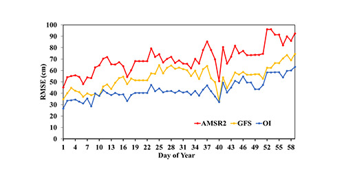
The development of a snow depth product over North America is investigated by applying two-dimensional optimal interpolation to passive microwave satellite-derived and in-situ measured snow depth. At each snow-covered satellite footprint, the technique computes a snow depth increment as the weighted average of data increments, and updates the satellite-derived snow depth accordingly. Data increments are computed as the difference between the in-situ-measured and satellite snow depth at station locations surrounding the satellite footprint. Calculation of optimal weights is based on spatial lag autocorrelation of snow depth increments, modelled as functions of horizontal distance and elevation difference between pairs of observations. The technique is applied to Advanced Microwave Scanning Radiometer 2 (AMSR2) snow depth and in-situ snow depth obtained from the Global Historical Climatology Network. The results over North America during January–February 2017 indicate that the technique greatly enhances the performance of the satellite estimates, especially over mountain terrain, albeit with an accuracy inferior to that over low elevation areas. Moreover, the technique generates more accurate output compared to that from NOAA’s Global Forecast System, with implications for improving the utilization of satellite data in snow assessments and numerical weather prediction. Full article
Show Figures

Graphical abstract

Back to TopTop