Next Issue
Volume 10, June
Previous Issue
Volume 10, April


Geosciences, Volume 10, Issue 5 (May 2020) – 49 articles

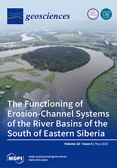
Cover Story (view full-size image): The image was taken from unmanned aerial vehicles DJI PHANTOM from a height of 800 m. The floodplain massif of Iya river (a tributary of the Angara River) is shown during the passage of the second wave of a catastrophic flood in the summer of 2019, when many areas of the Angara region suffered from floods caused by increased cyclonic activity. Floodplain flooding occurred at the river outlet from the East Sayan Mountains near the city of Tulun (Iya depression). In the broad sections of river valleys, which are characterized by a combination of segmented-ridge and hollow-island types of relief, as well as extensive swampy massifs, negative forms of the floodplain topography were flooded. View this paper.
  • Issues are regarded as officially published after their release is announced to the table of contents alert mailing list.
  • You may sign up for e-mail alerts to receive table of contents of newly released issues.
  • PDF is the official format for papers published in both, html and pdf forms. To view the papers in pdf format, click on the "PDF Full-text" link, and use the free Adobe Reader to open them.
Order results
Result details
Section
Select all
Export citation of selected articles as:
14 pages, 6655 KiB  
Article
Integrated Geodetic and Hydrographic Measurements of the Yacht Port for Nautical Charts and Dynamic Spatial Presentation
by Artur Makar, Cezary Specht, Mariusz Specht, Paweł Dąbrowski and Maciej Szafran
Geosciences 2020, 10(5), 203; https://doi.org/10.3390/geosciences10050203 - 25 May 2020
Cited by 11 | Viewed by 2990
Abstract
The use of geodetic and hydrographic systems, methods and measuring devices to obtain geospatial data enables integrated modeling of 3D space and related objects. Factors such as the seafloor relief of the marina and land infrastructure need to be considered to ensure safe [...] Read more.
The use of geodetic and hydrographic systems, methods and measuring devices to obtain geospatial data enables integrated modeling of 3D space and related objects. Factors such as the seafloor relief of the marina and land infrastructure need to be considered to ensure safe stay of vessels in the marina. The article presents the results of bathymetric and geodetic measurements of the yacht port of the National Sailing Centre in Gdańsk. They were made with the use of several measuring methods such as a hydrographic unmanned surface vessel, GNSS positioning, enabling geodetic inventory of hydrotechnical structures and port infrastructure, as well as laser scanning that resulted in three-dimensional presentation of land objects. As a result of research and analysis, a two-dimensional bathymetric chart of the yacht port was made. Thanks to the integration of geodetic and hydrographic data, three-dimensional visualization of the marina area was obtained. The charts can be used to ensure ship navigation safety when maneuvering in port and mooring at quays. Full article
Show Figures

Figure 1

18 pages, 4169 KiB  
Article
Deglaciation Rate of Selected Nunataks in Spitsbergen, Svalbard—Potential for Permafrost Expansion above the Glacial Environment
by Joanna Ewa Szafraniec and Wojciech Dobiński
Geosciences 2020, 10(5), 202; https://doi.org/10.3390/geosciences10050202 - 25 May 2020
Cited by 6 | Viewed by 3373
Abstract
Spitsbergen has recently experienced a continuous deglaciation process, linked to both glacier front retreat and lowering of the glacier surface. This process is accompanied by permafrost aggradation from the top of the slopes down to the glacier. Here, the authors determine the rate [...] Read more.
Spitsbergen has recently experienced a continuous deglaciation process, linked to both glacier front retreat and lowering of the glacier surface. This process is accompanied by permafrost aggradation from the top of the slopes down to the glacier. Here, the authors determine the rate of permafrost expansion in this type of vertical profile. To this end, seven nunataks across the island were analysed using Landsat satellite imagery, a high-resolution digital elevation model (ArcticDEM), and geoinformation software. Over the last 24–31 years, new nunataks gradually emerged from the ice cover at an average linear rate of 0.06 m a−1 per degree of increment of the slope of the terrain at an average altitude of approximately 640 m a.s.l. The analysis showed that the maximum rate of permafrost expansion down the slope was positively correlated with the average nunatak elevation, reaching a value of approximately 10,000 m2 a−1. In cold climates, with a mean annual air temperature (MAAT) below 0 °C, newly exposed land is occupied by active periglacial environments, causing permafrost aggradation. Therefore, both glacial and periglacial environments are changing over time concomitantly, with permafrost aggradation occurring along and around the glacier, wherever the MAAT is negative. Full article
Show Figures

Graphical abstract

20 pages, 10945 KiB  
Article
Transport and Evolution of Supercritical Fluids During the Formation of the Erdenet Cu–Mo Deposit, Mongolia
by Geri Agroli, Atsushi Okamoto, Masaoki Uno and Noriyoshi Tsuchiya
Geosciences 2020, 10(5), 201; https://doi.org/10.3390/geosciences10050201 - 25 May 2020
Cited by 5 | Viewed by 4151
Abstract
Petrological and fluid inclusion data were used to characterize multiple generations of veins within the Erdenet Cu–Mo deposit, Mongolia, and constrain the evolution of fluids within the magmatic–hydrothermal system. Three types of veins are present (from early to late): quartz–molybdenite, quartz–pyrite, and quartz. [...] Read more.
Petrological and fluid inclusion data were used to characterize multiple generations of veins within the Erdenet Cu–Mo deposit, Mongolia, and constrain the evolution of fluids within the magmatic–hydrothermal system. Three types of veins are present (from early to late): quartz–molybdenite, quartz–pyrite, and quartz. The host rock was emplaced at temperatures of 700–750 °C, the first quartz was precipitated from magma-derived supercritical fluids at 650–700 °C, quartz–molybdenite and quartz–pyrite veins were formed at ~600 °C, and the quartz veins were precipitated in response to retrograde silica solubility caused by decreasing temperatures at <500 °C. We infer that over-pressured fluid beneath the cupola caused localized fluid injection, or that accumulated stress caused ruptures and earthquakes related to sector collapse; these events disrupted impermeable layers and allowed fluids to percolate through weakened zones. Full article
(This article belongs to the Special Issue Exploring and Modeling the Magma-Hydrothermal Regime)
Show Figures

Figure 1

13 pages, 2223 KiB  
Article
Assessing Ecosystem Services of Atmospheric Calcium and Magnesium Deposition for Potential Soil Inorganic Carbon Sequestration
by Elena A. Mikhailova, Hamdi A. Zurqani, Christopher J. Post and Mark A. Schlautman
Geosciences 2020, 10(5), 200; https://doi.org/10.3390/geosciences10050200 - 25 May 2020
Cited by 4 | Viewed by 3640
Abstract
Many soil regulating ecosystem services (ES) are linked to Earth’s atmosphere, but associated monetary values often are unknown or difficult to quantify. Atmospheric deposition of calcium (Ca2+) and magnesium (Mg2+) are abiotic flows (wet, dry, and total) from the [...] Read more.
Many soil regulating ecosystem services (ES) are linked to Earth’s atmosphere, but associated monetary values often are unknown or difficult to quantify. Atmospheric deposition of calcium (Ca2+) and magnesium (Mg2+) are abiotic flows (wet, dry, and total) from the atmosphere to land surfaces, which potentially can become available to sequester carbon (C) as soil inorganic carbon (SIC). However, these processes typically have not been included in economic valuations of ecosystem services. The primary objective of this study was to demonstrate an approach for valuing non-constrained potential SIC sequestration from atmospheric Ca2+ and Mg2+ deposition based on the concept of the avoided social cost of carbon dioxide emissions (SC-CO2). Maximum monetary values associated with the non-constrained potential SIC sequestration were compiled for the contiguous United States (U.S.) by soil order, land resource region (LRR), state, and region using available deposition data from the National Atmospheric Deposition Program (NRSP-3). For the entire contiguous U.S., an average annual monetary value for the non-constrained potential SIC sequestration due to atmospheric Ca2+ and Mg2+ deposition was $135M (i.e., $135 million U.S. dollars, where M = million = 106). Mollisols, Alfisols, and Entisols were soil orders with the highest average annual monetary values for non-constrained potential SIC sequestration. When normalized by land area, however, Vertisols had the highest average annual monetary values followed by Alfisols and Mollisols for non-constrained potential SIC sequestration. From a more agricultural perspective, the LRRs with the highest average annual monetary values for non-constrained potential SIC sequestration were the Western Range and Irrigated Region (D), the Central Feed Grains and Livestock Region (M), and the Central Great Plains Winter Wheat and Range Region (H). When normalized by area, the LRRS with the highest average annual monetary values were the Southwest Plateaus and Plains Range and Cotton Region (I) and the Florida Subtropical Fruit, Truck Crop and Range Region (U). Among the U.S. states, the highest average annual monetary values for non-constrained potential SIC sequestration were Texas, Kansas, and New Mexico, but when normalized by area the highest values by state were Kansas, Iowa, and Texas. Geographical regions in the contiguous U.S. with the highest average annual monetary values for non-constrained potential SIC sequestration were the South Central, Midwest, and West; when normalized by area, the highest values by region were South Central, Midwest, and Northern Plains. Constraints on maximum monetary values, based on physical, chemical, biological, economic, social, and political limitations, need to be considered and quantified to obtain more precise and accurate accounting of the ES associated with SIC sequestration due to atmospheric Ca2+ and Mg2+ deposition. Full article
Show Figures

Figure 1

24 pages, 5784 KiB  
Article
A Method for Quantitative Interpretation of Stationary Thermal Fields for Layered Media
by Igor V. Ladovskii, Petr S. Martyshko, Alexander G. Tsidaev and Denis D. Byzov
Geosciences 2020, 10(5), 199; https://doi.org/10.3390/geosciences10050199 - 22 May 2020
Cited by 7 | Viewed by 2325
Abstract
A new method to solve thermal conjugacy problems is presented for layered models with a thermal conductivity jump at their boundaries. The purpose of this method is to approximate the inverse thermal conductivity coefficient, which has breaks, by using a combination of step [...] Read more.
A new method to solve thermal conjugacy problems is presented for layered models with a thermal conductivity jump at their boundaries. The purpose of this method is to approximate the inverse thermal conductivity coefficient, which has breaks, by using a combination of step functions. A generalized continuous operator is constructed in a continuous space of piecewise–homogeneous media. We obtained an analytical solution for the stationary problem of heat conjugacy in the layered model with finite thickness and with Dirichlet–Neumann conditions at the external boundaries. An algorithm was constructed for downward continuation of the heat flux to depths that correspond to the top of the mantle layer. The advantages of this method are illustrated by testing the crustal seismic, gravity and geothermal data of a study area in the Urals and neighboring regions of Russia. We examined statistical relations between density and thermal parameters and determined heat flux components for the crust and the mantle. The method enables a downward continuation of the heat flux to the base of the upper mantle and allows us to determine the thermal effects of the lateral and vertical features of deep tectonic structures. Full article
(This article belongs to the Section Geophysics)
Show Figures

Figure 1

13 pages, 4077 KiB  
Article
Conceptual Models of Gas Accumulation in the Shallow Permafrost of Northern West Siberia and Conditions for Explosive Gas Emissions
by Evgeny Chuvilin, Natalia Sokolova, Dinara Davletshina, Boris Bukhanov, Julia Stanilovskaya, Christian Badetz and Mikhail Spasennykh
Geosciences 2020, 10(5), 195; https://doi.org/10.3390/geosciences10050195 - 22 May 2020
Cited by 22 | Viewed by 14063
Abstract
Gas accumulation and pressurized unfrozen rocks under lakes (sublake taliks) subject to freezing in shallow permafrost may lead to explosive gas emissions and the formation of craters. Gas inputs into taliks may have several sources: microbially-mediated recycling of organic matter, dissociation of intrapermafrost [...] Read more.
Gas accumulation and pressurized unfrozen rocks under lakes (sublake taliks) subject to freezing in shallow permafrost may lead to explosive gas emissions and the formation of craters. Gas inputs into taliks may have several sources: microbially-mediated recycling of organic matter, dissociation of intrapermafrost gas hydrates, and migration of subpermafrost and deep gases through permeable zones in a deformed crust. The cryogenic concentration of gas increases the pore pressure in the freezing gas-saturated talik. The gradual pressure buildup within the confined talik causes creep (ductile) deformation of the overlying permafrost and produces a mound on the surface. As the pore pressure in the freezing talik surpasses the permafrost strength, the gas-water-soil mixture of the talik erupts explosively and a crater forms where the mound was. The critical pressure in the confined gas-saturated talik (2–2.5 MPa for methane) corresponds to the onset of gas hydrate formation. The conditions of gas accumulation and excess pressure in freezing closed taliks in shallow permafrost, which may be responsible for explosive gas emissions and the formation of craters, are described by several models. Full article
(This article belongs to the Special Issue Gas Emissions and Crater Formation in Arctic Permafrost)
Show Figures

Figure 1

23 pages, 5084 KiB  
Article
Shape and Dimension Estimations of Landslide Rupture Zones via Correlations of Characteristic Parameters
by Gisela Domej, Céline Bourdeau, Luca Lenti, Salvatore Martino and Kacper Pluta
Geosciences 2020, 10(5), 198; https://doi.org/10.3390/geosciences10050198 - 21 May 2020
Cited by 6 | Viewed by 3365
Abstract
For many geotechnical purposes, the proper estimation of shapes and dimensions of landslide rupture zones is of significant importance. Very often, this exact delineation is difficult due to the lack of information on rupture zone extents in 3D. Based on a global landslide [...] Read more.
For many geotechnical purposes, the proper estimation of shapes and dimensions of landslide rupture zones is of significant importance. Very often, this exact delineation is difficult due to the lack of information on rupture zone extents in 3D. Based on a global landslide inventory, this work presents statistical analyses correlating dimension-related and shape-related parameters characterizing a rupture zone in 3D to its volume. Dimension-related parameters are approximated by linear regressions increasing with greater volumes, whereas shape-related parameters appear stable throughout the entire range of volumes. Revealing themselves as very stable, these correlations can be used, hence, to extrapolate from a distinct parameter to the volume of a landslide rupture zone. In a second stage, ratios of dimension-related parameters are correlated with rupture zone volumes. Furthermore, this type of correlation delivers very stable results showing that ratios are constant throughout the entire range of volumes. Making use of this ratio consistency, it is possible to deduce one of the two parameters when the other one is given. This latter aspect seems to be promising for remote sensing surveys when initial rupture areas or rupture volumes should be delineated or for numerical modeling of landslides in 3D. Full article
(This article belongs to the Section Natural Hazards)
Show Figures

Figure 1

21 pages, 23879 KiB  
Article
Zircons from a Pegmatite Cutting Eclogite (Gridino, Belomorian Mobile Belt): U-Pb-O and Trace Element Constraints on Eclogite Metamorphism and Fluid Activity
by Sergey G. Skublov, Aleksey V. Berezin, Xian-Hua Li, Qiu-Li Li, Laysan I. Salimgaraeva, Veniamin V. Travin and Dmitriy I. Rezvukhin
Geosciences 2020, 10(5), 197; https://doi.org/10.3390/geosciences10050197 - 21 May 2020
Cited by 12 | Viewed by 3287
Abstract
This report presents new data on U-Pb geochronology, oxygen isotopes, and trace element composition of zircon from a pegmatite vein crosscutting an eclogite boudin on Stolbikha Island, Gridino area, Belomorian mobile belt (BMB). The zircon grains occur as two distinct populations. The predominant [...] Read more.
This report presents new data on U-Pb geochronology, oxygen isotopes, and trace element composition of zircon from a pegmatite vein crosscutting an eclogite boudin on Stolbikha Island, Gridino area, Belomorian mobile belt (BMB). The zircon grains occur as two distinct populations. The predominant population is pegmatitic and shows dark cathodoluminescence (CL); about a third of this population contains inherited cores. The second zircon population is typical of granulite and exhibits a well-defined sectorial (mosaic) zoning in CL. Both the inherited cores and sectorial in CL zircons appear to have been captured from metabasites as xenocrysts during the pegmatite vein formation. A U-Pb age of 1890 ± 2 Ma for the main zircon population is interpreted as the age of the pegmatite injection. This value is close to the age threshold for the BMB eclogites (~1.9 Ga) and unambiguously defines the upper age limit for the eclogite metamorphism. The pegmatite formation is thus related to partial melting events that occurred during the retrograde amphibolite-facies metamorphism shortly after the eclogitization. A U-Pb date of 2743 ± 10 Ma obtained for the sectorial in CL zircons is considered as the age of the granulite-facies metamorphism established previously within the BMB. The values of δ18O in the zircon populations overlap in a broad range, i.e., δ18O in the pegmatitic zircons varies from 6.1‰ to 8.3‰, inherited cores show a generally higher δ18O of 6.7–8.8‰, and in the captured granulitic zircons δ18O is 6.2–7.9‰. As a result of fluid attack during the final stage of the pegmatite vein formation, the composition of the pegmatitic zircons in terms of non-formula elements (REE, Y, Ca, Sr, Ti) has become anomalous, with the content of these elements having been increased by more than tenfold in the alteration zones. Our data provide new constraints on the timing of eclogite metamorphism within the BMB and show that the late-stage pegmatite-related fluids exerted a very pronounced influence on trace element abundances in zircon, yet had no significant impact on the isotopic composition of oxygen. Full article
(This article belongs to the Special Issue Distribution of REE and Trace Elements for Different Types of Zircons)
Show Figures

Figure 1

32 pages, 7131 KiB  
Article
Porphyroclasts: Source and Sink of Major and Trace Elements During Deformation-Induced Metasomatism (Finero, Ivrea-Verbano Zone, Italy)
by Stefania Corvò, Antonio Langone, José Alberto Padrón-Navarta, Andrea Tommasi and Alberto Zanetti
Geosciences 2020, 10(5), 196; https://doi.org/10.3390/geosciences10050196 - 21 May 2020
Cited by 11 | Viewed by 3600
Abstract
Petrographic and geochemical data for mylonites from a metric-scale shear zone in mantle peridotites from the Finero massif (Southern Alps) record large mineralogical and geochemical modifications compared to surrounding coarse-grained ultramafic rocks, which were pervasively deformed in presence of hydrous melts. The mylonites [...] Read more.
Petrographic and geochemical data for mylonites from a metric-scale shear zone in mantle peridotites from the Finero massif (Southern Alps) record large mineralogical and geochemical modifications compared to surrounding coarse-grained ultramafic rocks, which were pervasively deformed in presence of hydrous melts. The mylonites are composed by olivine and orthopyroxene and, less frequently, clinopyroxene, phlogopite, and pargasite porphyroclasts enclosed in a fine-grained matrix of phlogopite and olivine, with subordinate amounts of orthopyroxene, clinopyroxene, pargasite, and chromite. P-T estimates indicate that deformation occurred under granulite- to upper-amphibolite facies conditions. Field relationships and U-Pb dating indicate that the shear zone was active during Lower Jurassic and/or later, in an extensional setting at the western margin of the Adria plate, which led to the opening of the Alpine Tethys. The major and trace element composition of the porphyroclasts in the mylonites significantly differ from those in the hosting coarse-grained ultramafics. Porphyroclasts were chemically active during deformation acting as source (diffusion-out) or sink (diffusion-in) for some trace elements. The chemical modifications were promoted by the interaction with aqueous fluids and the composition varied from mantle- (enriched in Ni, Co, Li, Na, REE, Y, and Sr) to crustal-derived (enriched in Zn, K, Al, Ti, and Fe). Full article
Show Figures

Figure 1

13 pages, 3319 KiB  
Article
Zircon as a Mineral Indicating the Stage of Granitoid Magmatism at Northern Chukotka, Russia
by Viktor I. Alekseev and Ivan V. Alekseev
Geosciences 2020, 10(5), 194; https://doi.org/10.3390/geosciences10050194 - 20 May 2020
Cited by 6 | Viewed by 3523
Abstract
A comparative study of the zircon composition and texture in granites of a three-stage Late Cretaceous magmatism in the Chaun area, Chukotka, Russia, was conducted in biotite granites (BG), quartz monzonites-monzogranites (MG), and zinnwaldite granites (ZG). The significance of the study entails determining [...] Read more.
A comparative study of the zircon composition and texture in granites of a three-stage Late Cretaceous magmatism in the Chaun area, Chukotka, Russia, was conducted in biotite granites (BG), quartz monzonites-monzogranites (MG), and zinnwaldite granites (ZG). The significance of the study entails determining the mineralogical indicators of similar granitoids in areas of multi-stage petrogenesis. It is shown that in the rock series of Northern Chukotka, BG → MG → ZG, a morphological evolution of zircon takes place: a reduction in size, elongation, a growing complexity of the crystallography, and an individual texture. In later generations of zircon, as a result of the recrystallization and metasomatism, rare-metal overgrowths, defects in the crystal structure, pores and fissures, and mineral inclusions appear, whereas the crystal-face indices and patterns become more complicated. We can observe the geochemical evolution of zircon: a gradual change in the concentration of trace elements (Hf, U, Y, Th, Nb, and Ti), rare earth elements (Yb, Er, and Dy, as well as Ce and Nd), and uncommon elements (Ca and Al). Rare elements (REE, Y, Hf, Nb, U, and Th) at the post-magmatic stage of the regional history acquired economic abundances. Zircon is therefore indicative of productive ore-magmatic systems. Full article
(This article belongs to the Special Issue Distribution of REE and Trace Elements for Different Types of Zircons)
Show Figures

Figure 1

12 pages, 2776 KiB  
Article
The Occurrence of Permafrost within the Glacial Domain
by Wojciech Dobiński
Geosciences 2020, 10(5), 193; https://doi.org/10.3390/geosciences10050193 - 20 May 2020
Cited by 4 | Viewed by 3496
Abstract
The occurrence of permafrost within glacial environments has never been comprehensively defined based on scientific evidence, despite its importance in determining how all the components of the cryosphere associate and interact. Here, the relation between glaciers and permafrost is discussed based on what [...] Read more.
The occurrence of permafrost within glacial environments has never been comprehensively defined based on scientific evidence, despite its importance in determining how all the components of the cryosphere associate and interact. Here, the relation between glaciers and permafrost is discussed based on what scientific field they have been traditionally associated with. As the most accepted definition of permafrost is not exclusively linked to the presence of a geological medium, this can also be ice of any origin, including snow and glacial ice. Thus, active glaciers can act as permafrost medium. Indeed, all thermal types of glaciers meet the definition of permafrost as they remain at or below 0 °C for certainly more than two consecutive years. Active rock glaciers, regardless of the origin of the ice within, also meet the definition of permafrost. The presence of an active layer is not a prerequisite for the existence of permafrost either. Therefore, a comprehensive definition of permafrost occurrence across the cryosphere is essential to appropriately understand the phenomenon as a whole, not only as seen from our planet but also as it occurs for example on the icy moons of the Solar System and other frozen rocky bodies. Full article
Show Figures

Figure 1

16 pages, 4154 KiB  
Article
Hydrogeology of Reclaimed Floodplain in A Permafrost Area, Yakutsk, Russia
by Nadezhda Pavlova, Vasily Ogonerov, Marina Danzanova and Vladimir Popov
Geosciences 2020, 10(5), 192; https://doi.org/10.3390/geosciences10050192 - 20 May 2020
Cited by 4 | Viewed by 3626
Abstract
A study was performed to evaluate the current permafrost and groundwater conditions in the reclaimed floodplain of the Lena, one of the largest rivers in the permafrost zone. Data from ongoing hydrogeological monitoring were compared with earlier observations conducted during the reclamation process. [...] Read more.
A study was performed to evaluate the current permafrost and groundwater conditions in the reclaimed floodplain of the Lena, one of the largest rivers in the permafrost zone. Data from ongoing hydrogeological monitoring were compared with earlier observations conducted during the reclamation process. The results demonstrate that the placement of dredged fill led to the development of suprapermafrost thaw zones (taliks). The anthropogenic taliks vary in thickness from 10 to 15 m in areas of buried bars to 20 m or more in the former locations of oxbow lakes. There is similarity in seasonal groundwater fluctuation patterns and response to river stage variations across the study area suggesting that a continuous aquifer connected to surface water. The connection with the river is most evident during the spring flood period. Two mechanisms of ground saturation are identified during this time. One is lateral seepage flow from the Lena River into the fill mass. The zone of its influence is limited to 150–170 m from the stream. The second is hydraulic pressure transmission from the river through the subchannel flow connected with the anthropogenic suprapermafrost aquifer. Its influence extends across the entire fill area. Continuous water movement at the base of the fill prevents permafrost aggradation from below. The study results should be taken into account when developing and implementing design and construction standards for engineering structures in the reclaimed floodplains of the permafrost zone. Full article
(This article belongs to the Special Issue Groundwater Flow Assessment)
Show Figures

Figure 1

17 pages, 1605 KiB  
Article
Bayesian Inference in Snow Avalanche Simulation with r.avaflow
by Jan-Thomas Fischer, Andreas Kofler, Andreas Huber, Wolfgang Fellin, Martin Mergili and Michael Oberguggenberger
Geosciences 2020, 10(5), 191; https://doi.org/10.3390/geosciences10050191 - 20 May 2020
Cited by 13 | Viewed by 4358
Abstract
Simulation tools for gravitational mass flows (e.g., avalanches, debris flows) are commonly used for research and applications in hazard assessment or mitigation planning. As a basis for a transparent and reproducible decision making process, associated uncertainties need to be identified in order to [...] Read more.
Simulation tools for gravitational mass flows (e.g., avalanches, debris flows) are commonly used for research and applications in hazard assessment or mitigation planning. As a basis for a transparent and reproducible decision making process, associated uncertainties need to be identified in order to quantify and eventually communicate the associated variabilities of the results. Main sources of variabilities in the simulation results are associated with parameter variations arising from observation and model uncertainties. These are connected to the measurement inaccuracies or poor process understanding and the numerical model implementation. Probabilistic approaches provide various theoretical concepts to treat these uncertainties, but their direct application is not straightforward. To provide a comprehensive tool, introducing conditional runout probabilities for the decision making process we (i) introduce a mathematical framework based on well-established Bayesian concepts, (ii) develop a work flow that couples this framework to the existing simulation tool r.avaflow, and (iii) apply the work flow to two case studies, highlighting its application potential and limitations. The presented approach allows for back, forward and predictive calculations. Back calculations are used to determine parameter distributions, identifying and mapping the model, implementation and data uncertainties. These parameter distributions serve as a base for forward and predictive calculations, embedded in the probabilistic framework. The result variability is quantified in terms of conditional probabilities with respect to the observed data and the associated simulation and data uncertainties. To communicate the result variability the conditional probabilities are visualized, allowing to identify areas with large or small result variability. The conditional probabilities are particularly interesting for predictive avalanche simulations at locations with no prior information where visualization explicitly shows the result variabilities based on parameter distributions derived through back calculations from locations with well-documented observations. Full article
(This article belongs to the Special Issue Snow Avalanche Dynamics)
Show Figures

Figure 1

13 pages, 3322 KiB  
Article
Tropical Cyclone Impacts on Headland Protected Bay
by Daniel Wishaw, Javier X. Leon, Matthew Barnes and Helen Fairweather
Geosciences 2020, 10(5), 190; https://doi.org/10.3390/geosciences10050190 - 19 May 2020
Cited by 4 | Viewed by 5160
Abstract
The response of headland protected beaches to storm events is complex and strongly site dependent. In this study, we investigated the response of several headland protected beaches in Noosa, Australia to a tropical cyclone event. Pre and post topographical surveys of all beaches [...] Read more.
The response of headland protected beaches to storm events is complex and strongly site dependent. In this study, we investigated the response of several headland protected beaches in Noosa, Australia to a tropical cyclone event. Pre and post topographical surveys of all beaches were completed using both pole-mounted RTK-GNSS and structure-from-motion (SfM)-derived elevation models from survey-grade drone imagery to assess sediment volume differentials. Coastal imaging was used to assess shoreline development and identify coastal features while a nearshore wave model (SWAN) was used to project waves into the study site from a regional wave buoy. Obliquely orientated swells drive currents along the headland with sediment being eroded from exposed sites and deposited at a protected site. Elevated sea-levels were shown to be a strong force-multiplier for relatively small significant wave heights, with 10,000 m3 of sediment eroded from a 700 m long beach in 36 h. The SWAN model was adequately calibrated for significant wave height, but refraction of swell around the headland was under-represented by an average of 16.48 degrees. This research has coastal management implications for beaches where development restricts natural shoreline retreat and elevated sea states are likely to become more common. Full article
(This article belongs to the Special Issue Coastal Morphodynamics and Geomorphology)
Show Figures

Figure 1

21 pages, 746 KiB  
Review
Previous, Current, and Future Trends in Research into Earthquake Precursors in Geofluids
by Giovanni Martinelli
Geosciences 2020, 10(5), 189; https://doi.org/10.3390/geosciences10050189 - 19 May 2020
Cited by 31 | Viewed by 6053
Abstract
Hazard reduction policies include seismic hazard maps based on probabilistic evaluations and the evaluation of geophysical parameters continuously recorded by instrumental networks. Over the past 25 centuries, a large amount of information about earthquake precursory phenomena has been recorded by scholars, scientific institutions, [...] Read more.
Hazard reduction policies include seismic hazard maps based on probabilistic evaluations and the evaluation of geophysical parameters continuously recorded by instrumental networks. Over the past 25 centuries, a large amount of information about earthquake precursory phenomena has been recorded by scholars, scientific institutions, and civil defense agencies. In particular, hydrogeologic measurements and geochemical analyses have been performed in geofluids in search of possible and reliable earthquake precursors. Controlled experimental areas have been set up to investigate physical and chemical mechanisms originating possible preseismic precursory signals. The main test sites for such research are located in China, Iceland, Japan, the Russian Federation, Taiwan, and the USA. The present state of the art about the most relevant scientific achievements has been described. Future research trends and possible development paths have been identified and allow for possible improvements in policies oriented to seismic hazard reduction by geofluid monitoring. Full article
(This article belongs to the Special Issue 2020: A 10 Years Journey-Advances in Geosciences)
Show Figures

Figure 1

22 pages, 5987 KiB  
Article
Recent Advances in Geomathematics in Croatia: Examples from Subsurface Geological Mapping and Biostatistics
by Tomislav Malvić, Marija Bošnjak, Josipa Velić, Jasenka Sremac, Josip Ivšinović, Maria Alzira Pimenta Dinis and Uroš Barudžija
Geosciences 2020, 10(5), 188; https://doi.org/10.3390/geosciences10050188 - 15 May 2020
Cited by 2 | Viewed by 3661
Abstract
Geomathematics is extremely important in geosciences, particularly in the geology. The key for any geomathematical analysis is the definition of a typical model to be applied for further prognosis, either through deterministic or stochastic approaches. The selection of the appropriate procedure is presented [...] Read more.
Geomathematics is extremely important in geosciences, particularly in the geology. The key for any geomathematical analysis is the definition of a typical model to be applied for further prognosis, either through deterministic or stochastic approaches. The selection of the appropriate procedure is presented in this paper. Two different geomathematical subfield datasets were used in subsurface geological mapping and palaeontology and different biostatistics applications, representing important geomathematical subfields in the Croatian geology. The different subsurface interpolation methods tested, validated and recommended for application were used to obtain the best possible outcome in reservoir modelling, in the cases with small datasets. Cross-validation may be chosen as the main selection criteria, applied to the Croatian part of the Pannonian Basin System (CPBS). Recent advances in biostatistics applied in palaeontology and case studies from Croatia are also presented, where biometric studies are of significant importance in fossil biota. Data, methods and problems in geosciences are vast subjects, and address a wide spectrum of fundamental science. Because geology includes subsurface and surface geology, and very different datasets regarding variable and number of data, we have chosen here two representative case study groups with original samples from Northern Croatia. Subsurface mapping has been presented on limited petrophysical datasets from the Northern Croatian, Miocene, hydrocarbon reservoirs. Biostatistics have been presented on very different samples, allowing us to achieve paleoenvironmental reconstructions of the size of relevant fossils, such as dinosaurs or other species and their paleoenvironments. All examples highlight examples of the valuable application of geomathematical tools in geology. The results, cautiously validated and correlated with other, non-numerical (indicator, categorical) geological knowledge, are of enormous assistance in creating better geological models. Full article
(This article belongs to the Special Issue 2020: A 10 Years Journey-Advances in Geosciences)
Show Figures

Figure 1

25 pages, 33886 KiB  
Article
The Contribution of Geophysics to the Knowledge of the Hidden Archaeological Heritage of Montenegro
by Marilena Cozzolino, Mile Baković, Nikola Borovinić, Giorgia Galli, Vincenzo Gentile, Marija Jabučanin, Paolo Mauriello, Pasquale Merola and Miloš Živanović
Geosciences 2020, 10(5), 187; https://doi.org/10.3390/geosciences10050187 - 15 May 2020
Cited by 14 | Viewed by 4174
Abstract
Montenegro is a land of great history which needs attention and care for a deeper knowledge and its making at the disposal of new generations. It is still a territory to be discovered, studied, and disclosed. It is important to understand how much [...] Read more.
Montenegro is a land of great history which needs attention and care for a deeper knowledge and its making at the disposal of new generations. It is still a territory to be discovered, studied, and disclosed. It is important to understand how much hidden heritage there is still in this area to explore and exploit, but on the other hand, how much known heritage exists to protect and monitor, preventing its destruction and loss. In this context, Montenegro is heavily investing in the management of cultural heritage through initiatives for identification, protection, preservation, enhancement and fruition of them. In the frame of the knowledge, the use of non-destructive geophysical methods can be helpful for a cognitive investigation immediately in the bud of any archaeological verification project, safeguarded through preventive archaeology operations and the exploration of large areas within archaeological parks. In this paper, the results of geophysical prospections at the Hellenistic-Illyrian site of Mjace, the roman towns of Doclea and Municipium S, the medieval city of Svač, and the Stećci medieval tombstones graveyards of Novakovići, Žugića, and Plužine are presented. The study allowed the reconnaissance of new buried structures in the soil and has provided an updated view of the rich archaeological heritage of Montenegro. Full article
Show Figures

Figure 1

19 pages, 24752 KiB  
Article
Mainshock Anticipated by Intra-Sequence Ground Deformations: Insights from Multiscale Field and SAR Interferometric Measurements
by Francesco Brozzetti, Alessandro Cesare Mondini, Cristina Pauselli, Paolo Mancinelli, Daniele Cirillo, Fausto Guzzetti and Giusy Lavecchia
Geosciences 2020, 10(5), 186; https://doi.org/10.3390/geosciences10050186 - 15 May 2020
Cited by 19 | Viewed by 3768
Abstract
The 2016 Central Italy seismic sequence was characterized by two main events: 24 August, Mw 6, and 30 October, Mw 6.5. We carried out high-resolution field sampling and DInSAR analysis of the coseismic and intra-sequence ground deformations along the Mt Vettore-Mt Bove causative [...] Read more.
The 2016 Central Italy seismic sequence was characterized by two main events: 24 August, Mw 6, and 30 October, Mw 6.5. We carried out high-resolution field sampling and DInSAR analysis of the coseismic and intra-sequence ground deformations along the Mt Vettore-Mt Bove causative fault (VBF). We found that during the intra-sequence period (24 August–30 October), the ground experienced some deformations whose final patterns seemed to be retraced and amplified by the following mainshock. We interpreted that (i) immediately after the 24 August earthquake, the deformation observed in the southern VBF expanded northwards and westwards over a Length of Deforming Ground (LDG) ranging between 28.7 and 36.3 km, and (ii) it extended to the whole portion of the hanging wall that was later affected by mainshock coseismic deformation. Assuming the LDG to be an indicator for an expected (=coseismic) surface rupture length and using known scaling functions, we obtained 6.4 ≤ Mw ≤ 6.7 for a possible incoming earthquake, which is consistent with the mainshock magnitude. We suggest that the evolution of the ground deformations after a significant seismic event might provide insights on the occurrence of new earthquakes with magnitudes comparable to or larger than the former. Full article
(This article belongs to the Special Issue Seismic Sequence in Mediterranean Region)
Show Figures

Figure 1

16 pages, 2001 KiB  
Article
Granger Causality Analysis of Geophysical, Geodetic and Geochemical Observations during Volcanic Unrest: A Case Study in the Campi Flegrei Caldera (Italy)
by Simona Tripaldi, Sergio Scippacercola, Annarita Mangiacapra and Zaccaria Petrillo
Geosciences 2020, 10(5), 185; https://doi.org/10.3390/geosciences10050185 - 15 May 2020
Cited by 2 | Viewed by 3234
Abstract
The recent signs of reawakening at Campi Flegrei caldera (Southern Italy) received a great deal of attention due to the issues related to the volcanic risk management in a densely populated area. This paper explores relations between ground deformations, seismicity and geochemical time [...] Read more.
The recent signs of reawakening at Campi Flegrei caldera (Southern Italy) received a great deal of attention due to the issues related to the volcanic risk management in a densely populated area. This paper explores relations between ground deformations, seismicity and geochemical time series in the time span 2004–2016. The aim is to unravel primary processes of unrest and the related indicators which may change in time. Data structure and interactions among variables were examined applying the clustering analysis, the correlations and the Granger causality test. The hierarchical agglomerative clustering detected two sub-periods which were further investigated. In both sub-period causal links were observed between variables while correlations did not appear and vice versa. Thus, well established formal approaches are required to study causal relations. Granger test results indicate that during 2004–2011 the awakening unrest could be mainly ascribed to hydrothermal system pressure fluctuations, probably induced by deep-rooted fluids injection, and that ground deformation together with CO2/H2O appears the most suitable geo-indicators. The 2011–2016 sub-period is characterized by enhanced dynamical connectivity. Granger test results suggest that the unrest is driven by a more localized and shallower thermohydromechanical engine. CO/CO2, He/CH4 and ground deformation velocity are mutually interacting appearing the most suitable geo-indicators. Full article
(This article belongs to the Special Issue Modern Surveying and Geophysical Methods for Soil and Rock)
Show Figures

Figure 1

6 pages, 817 KiB  
Article
Natural Gas Liberations around Production Wells at Russian Arctic Gas Fields
by Vladimir S. Yakushev
Geosciences 2020, 10(5), 184; https://doi.org/10.3390/geosciences10050184 - 15 May 2020
Cited by 10 | Viewed by 3485
Abstract
Gas samples from gas liberations around wellheads on two giant natural gas fields in West Siberia (Bovanenkovo and Yamburg) have been tested for their carbon isotopic and molecular compositions. Results have shown local, microbial genesis of gas and that its source is permafrost [...] Read more.
Gas samples from gas liberations around wellheads on two giant natural gas fields in West Siberia (Bovanenkovo and Yamburg) have been tested for their carbon isotopic and molecular compositions. Results have shown local, microbial genesis of gas and that its source is permafrost at both gas fields. Gas liberation is caused by permafrost rock massif thawing around working well. Gas liberations can appear at different distances from the casing inside the radius of thawing. Two gas samples taken from gas liberations at casing border have shown thermogenic origin, which was explained by deep gas leakage through the casing. Gas liberations from deep production horizons are few, and they concentrate around the casing. Permafrost gas liberations are numerous, and they are spread at different distances from the wellhead. Full article
(This article belongs to the Special Issue Gas Emissions and Crater Formation in Arctic Permafrost)
Show Figures

Figure 1

25 pages, 14491 KiB  
Article
Shallow Magmatic Hydrothermal Eruption in April 2018 on Ebinokogen Ioyama Volcano in Kirishima Volcano Group, Kyushu, Japan
by Yasuhisa Tajima, Setsuya Nakada, Fukashi Maeno, Toshio Huruzono, Masaaki Takahashi, Akihiko Inamura, Takeshi Matsushima, Masashi Nagai and Jun Funasaki
Geosciences 2020, 10(5), 183; https://doi.org/10.3390/geosciences10050183 - 14 May 2020
Cited by 24 | Viewed by 6500
Abstract
The Kirishima Volcano Group is a volcanic field ideal for studying the mechanism of steam-driven eruptions because many eruptions of this type occurred in the historical era and geophysical observation networks have been installed in this volcano. We made regular geothermal observations to [...] Read more.
The Kirishima Volcano Group is a volcanic field ideal for studying the mechanism of steam-driven eruptions because many eruptions of this type occurred in the historical era and geophysical observation networks have been installed in this volcano. We made regular geothermal observations to understand the hydrothermal activity in Ebinokogen Ioyama Volcano. Geothermal activity resumed around the Ioyama from December 2015. A steam blowout occurred in April 2017, and a hydrothermal eruption occurred in April 2018. Geothermal activity had gradually increased before these events, suggesting intrusion of the magmatic component fluids in the hydrothermal system under the volcano. The April 2018 eruption was a magmatic hydrothermal eruption caused by the injection of magmatic fluids into a very-shallow hydrothermal system as a bottom–up fluid pressurization, although juvenile materials were not identifiable. Additionally, the upwelling of mixed magma–meteoric fluids to the surface as a kick was observed just before the eruption to cause the top–down flashing of April 2018. A series of events was generated in the shallower hydrothermal regime consisting of multiple systems divided by conductive caprock layers. Full article
(This article belongs to the Special Issue Exploring and Modeling the Magma-Hydrothermal Regime)
Show Figures

Figure 1

17 pages, 6080 KiB  
Article
Lime Treatment of a Soft Sensitive Clay: A Sustainable Reuse Option
by Marta Di Sante, Bruno Di Buò, Evelina Fratalocchi and Tim Länsivaara
Geosciences 2020, 10(5), 182; https://doi.org/10.3390/geosciences10050182 - 14 May 2020
Cited by 12 | Viewed by 4375
Abstract
This paper presents the results of research aimed at studying the hydraulic and mechanical behavior of Finnish soft clays treated by quicklime. This research investigated the effect of water content and curing time on the characteristics of the compacted soil treated with 7% [...] Read more.
This paper presents the results of research aimed at studying the hydraulic and mechanical behavior of Finnish soft clays treated by quicklime. This research investigated the effect of water content and curing time on the characteristics of the compacted soil treated with 7% lime, with the aim of verifying the effectiveness of lime treatment and evaluating its possible re-use, thus avoiding landfill disposal. A laboratory-testing program was carried out both on treated and untreated soil, supported by microstructural investigation. Results have shown a general increase of the hydraulic conductivity due to the addition of lime, reduction of compressibility, and increase in the soil shear strength for a wide range of water contents (10%–40%), proving the effectiveness of the lime treatment. Lime addition to the compacted clay at high water contents (90%–130%) turned out to improve the mechanical characteristics to a lesser extent, while fractionated lime supply did not significantly improve the mechanical performance. The results of this research demonstrate that the re-use of sensitive clays, typically of high water contents, by lime addition require a drying process. Different drying procedures can be adopted (proposed in the paper) depending on the specific site conditions. However, the soil treatment is generally economically convenient in comparison to the disposal in waste landfills, which would represent the only alternative solution. Full article
Show Figures

Figure 1

17 pages, 2306 KiB  
Article
The Khadzhokh Canyon System—An Important Geosite of the Western Caucasus
by Anna V. Mikhailenko, Dmitry A. Ruban and Vladimir A. Ermolaev
Geosciences 2020, 10(5), 181; https://doi.org/10.3390/geosciences10050181 - 14 May 2020
Cited by 7 | Viewed by 2922
Abstract
True diversity of geological heritage sites (geosites) is yet to be fully understood. New field studies of the Khadzhokh Canyon and its vicinities in the Western Caucasus (Mountainous Adygeya tourist destination, southwestern Russia) have allowed characterizing its geoheritage. Multiple unique features are assigned [...] Read more.
True diversity of geological heritage sites (geosites) is yet to be fully understood. New field studies of the Khadzhokh Canyon and its vicinities in the Western Caucasus (Mountainous Adygeya tourist destination, southwestern Russia) have allowed characterizing its geoheritage. Multiple unique features are assigned to geomorphological, stratigraphical, paleontological, palaeogeographical, sedimentary, tectonic, hydro(geo)logical, and coupled economical and geoexplorationgeoheritage types. This geoheritage is highlycomplex, and its rank is national. The unique features include (but not limited to) three canyons, Triassic stratigraphical sections, Late Jurassic coral reef, megaclast accumulations, chevron folds, and waterfalls. The geoheritage is distributed along the Khadzhokh Canyon and its branches. The configuration of thisgeositemakes it possible to propose a new category, namely dendritic geosites distinguished by continuous occurrence of geoheritage via branching stripes. Such geosites can be either natural (determined by dendritic drainage network and deep valley incision) or anthropogenic (determined by dendritic road network with lengthy road cuttings). In the former case, geosites are also geomorphosites and host viewpoint geosites. Full article
Show Figures

Graphical abstract

23 pages, 18097 KiB  
Article
A CO2-Driven Gas Lift Mechanism in Geyser Cycling (Uzon Caldera, Kamchatka)
by Alexey V. Kiryukhin and Gennady Karpov
Geosciences 2020, 10(5), 180; https://doi.org/10.3390/geosciences10050180 - 14 May 2020
Cited by 5 | Viewed by 2962
Abstract
Here, we report on a new geyser (named Shaman) formed in the Uzon caldera (Kronotsky Federal Nature Biosphere Reserve, Russia) in autumn 2008 from a cycling hot Na-Cl spring. The geyser is a pool-type CO2-gas lift driven. From 2012 to 2018, [...] Read more.
Here, we report on a new geyser (named Shaman) formed in the Uzon caldera (Kronotsky Federal Nature Biosphere Reserve, Russia) in autumn 2008 from a cycling hot Na-Cl spring. The geyser is a pool-type CO2-gas lift driven. From 2012 to 2018, the geyser has shown a rather stable interval between eruptions (IBE) from 129 to 144 min with a fountain height up to 4 m, and the geyser conduit has gradually enlarged. In 2019, the Shaman geyser eruption mode significantly changed: cold water inflow from the adjacent stream was re-directed into the geyser conduit and the average IBE decreased to 80 min. We observed two eruptive modes: a cycling hot spring (June 2019) and a cycling geyser (after June 2019). Bottom-hole temperature recording was performed in the geyser conduit to understand its activity. The TOUGH2-EOS2 model was used to reproduce the obtained temperature records and estimate geyser recharge/discharge parameters in both modes. Modeling shows that a larger cold inflow into the conduit causes a switch from cycling geyser to hot cycling spring mode. It was also found that the switch to cycling geyser mode corresponds to a larger mass of CO2 release during the time of the eruption. Full article
(This article belongs to the Special Issue Exploring and Modeling the Magma-Hydrothermal Regime)
Show Figures

Figure 1

11 pages, 6149 KiB  
Article
The Three-Segment Control and Measurement of Reliable Monitoring of the Deformation of the Rock Mass Surface and Engineering Structures on the Międzyodrze Islands in Szczecin, NW Poland
by Marek Zygmunt, Stefan Cacoń, Wojciech Milczarek, Józef Sanecki, Andrzej Piotrowski and Grzegorz Stępień
Geosciences 2020, 10(5), 179; https://doi.org/10.3390/geosciences10050179 - 13 May 2020
Cited by 2 | Viewed by 2686
Abstract
The research area is located in north-western Poland. It is the city of Szczecin with a particular emphasis on the Międzyodrze islands. The area of the EcoGenerator Waste Disposal Plant is part of the research area. The analysis of the geological structure of [...] Read more.
The research area is located in north-western Poland. It is the city of Szczecin with a particular emphasis on the Międzyodrze islands. The area of the EcoGenerator Waste Disposal Plant is part of the research area. The analysis of the geological structure of the subsurface layer of Earth’s crust within Szczecin, was carried out with particular emphasis on the EcoGenerator Waste Disposal Plant. The analysis of height changes of the benchmarks, was based on archival materials measured in two campaigns. A detailed recognition of the geological structure in connection with the analysis of changes in the height of the benchmarks was important. This enabled stable benchmarks to be located in several areas of Szczecin. They formed the basis for reliable monitoring of surface deformations of organic and existing sediments within the EkoGenerator Plant. The application of an appropriate three segment control and measurement system. In the area around the EcoGenerator Plant, vertical movements of the area were observed using the InSAR Small Baseline Subset Method. An InSAR analysis is only used here for very broad identification of the moving area. The radar data came from Sentinel 1 A and 1 B satellites. A total of 129 images from 15.11.2014 to 28.07.2019 were used.The results of the analyses conducted, form the basis for discussion and act as a summary of the considerations in this paper. Full article
(This article belongs to the Special Issue 2020: A 10 Years Journey-Advances in Geosciences)
Show Figures

Figure 1

27 pages, 7882 KiB  
Article
The Rockall and the Orphan Basins of the Southern North Atlantic Ocean: Determining Continuous Basins across Conjugate Margins
by Heide MacMahon, J. Kim Welford, Larry Sandoval and Alexander L. Peace
Geosciences 2020, 10(5), 178; https://doi.org/10.3390/geosciences10050178 - 13 May 2020
Cited by 9 | Viewed by 3836
Abstract
Reconstructions of the opening of the North Atlantic Ocean generally result in the Orphan Basin, offshore Newfoundland, Canada, lying approximately conjugate to the rift basins on the Irish Atlantic margin at the onset of seafloor spreading toward the end of the Early Cretaceous. [...] Read more.
Reconstructions of the opening of the North Atlantic Ocean generally result in the Orphan Basin, offshore Newfoundland, Canada, lying approximately conjugate to the rift basins on the Irish Atlantic margin at the onset of seafloor spreading toward the end of the Early Cretaceous. Most of these plate reconstructions have involved rigid plates with plate motions based solely on the interpretation of oceanic magnetic anomalies. In particular, these reconstructions often show the Rockall Basin, west of Ireland, forming a continuous Mesozoic basin with the West Orphan Basin, offshore Newfoundland. However, more recent plate reconstructions involving deformable plates have called this conjugate relationship into question. The goal of this study is to investigate the validity of this potentially continuous basin system by reconstructing and restoring present-day seismically-constrained geological models both spatially and temporally back to their original configurations pre-rift. By comparing the reconstructions in terms of sedimentary package thicknesses and crustal thicknesses in 3D, using both rigid and deformable plate reconstructions to orient the reconstructed models, we are able to test different basin connectivity scenarios using a multidisciplinary approach. Our analysis provides subsurface geophysical support for the hypothesis that the Rockall Basin was originally conjugate to and continuous with the East Orphan Basin during Jurassic rifting, later linking to the West Orphan Basin as rifting evolved during the Early Cretaceous. This complex basin evolution example highlights the need for using 3D rifting mechanism models to properly understand the fundamental driving forces during rifting and has significant implications for assessing basin prospectivity across conjugate margin pairs. Full article
Show Figures

Figure 1

28 pages, 24941 KiB  
Review
Tsunami Damage Detection with Remote Sensing: A Review
by Shunichi Koshimura, Luis Moya, Erick Mas and Yanbing Bai
Geosciences 2020, 10(5), 177; https://doi.org/10.3390/geosciences10050177 - 12 May 2020
Cited by 50 | Viewed by 11137
Abstract
Tsunamis are rare events compared with the other natural disasters, but once it happens, it can be extremely devastating to the coastal communities. Extensive inland penetration of tsunamis may cause the difficulties of understanding its impact in the aftermath of its generation. Therefore [...] Read more.
Tsunamis are rare events compared with the other natural disasters, but once it happens, it can be extremely devastating to the coastal communities. Extensive inland penetration of tsunamis may cause the difficulties of understanding its impact in the aftermath of its generation. Therefore the social needs to technologies of detecting the wide impact of great tsunamis have been increased. Recent advances of remote sensing and technologies of image analysis meet the above needs and lead to more rapid and efficient understanding of tsunami affected areas. This paper provides a review of how remote sensing methods have developed to contribute to post-tsunami disaster response. The evaluations in the performances of the remote sensing methods are discussed according to the needs of tsunami disaster response with future perspective. Full article
Show Figures

Figure 1

29 pages, 12283 KiB  
Article
The Functioning of Erosion-channel Systems of the River Basins of the South of Eastern Siberia
by Olga I. Bazhenova, Aleksandr V. Bardash, Stanislav A. Makarov, Marina Yu. Opekunova, Sergei A. Tukhta and Elizaveta M. Tyumentseva
Geosciences 2020, 10(5), 176; https://doi.org/10.3390/geosciences10050176 - 11 May 2020
Cited by 3 | Viewed by 3332
Abstract
We revealed the regional features of the functioning of the erosion-channel systems of the Angara, Upper Lena, Selenga, and Upper Amur basins in the south of Eastern Siberia and examined the action of sloping non-channel, temporary, and permanent channel water flows, and presented [...] Read more.
We revealed the regional features of the functioning of the erosion-channel systems of the Angara, Upper Lena, Selenga, and Upper Amur basins in the south of Eastern Siberia and examined the action of sloping non-channel, temporary, and permanent channel water flows, and presented the patterns of the spatial distribution of soil and gully erosion belts. The development conditions and factors of fluvial processes are considered and the role of cryogenic processes in the increasing activity of water flows is emphasized. The interdecadal dynamic cycles of the erosion-accumulative processes are revealed. A quantitative assessment of soil loss from erosion on agricultural land in the forest-steppe basins was carried out. We made an assessment of the plane deformation of the upper course of the Lena river (Siberian platform) and Irkut (Baikal rift zone and the Irkutsk-Cheremkhovo plain) using cartographic sources of different times, aerial photographs, and satellite imagery. The contribution of extreme fluvial events to sediment redistribution in river basins is shown. Particular attention is paid to the mudflow impact, floods, and channel deformations on the ecological state of the basin systems. Full article
(This article belongs to the Special Issue Geography and Geoecology of Rivers and River Basins)
Show Figures

Figure 1

19 pages, 5512 KiB  
Article
Assessment of Infrastructure Vulnerability to Tsunamis upon the Coastal Zone of Oman Using GIS
by Mohamed E. Hereher
Geosciences 2020, 10(5), 175; https://doi.org/10.3390/geosciences10050175 - 10 May 2020
Cited by 8 | Viewed by 4997
Abstract
The coastal zones of Oman are frequently exposed to tropical cyclones and are expected to be overwhelmed by tsunami waves that originate from marine earthquakes in the Indian Ocean. Inundation of low-lying coastal lands is, hence, inevitable. This study aims to provide a [...] Read more.
The coastal zones of Oman are frequently exposed to tropical cyclones and are expected to be overwhelmed by tsunami waves that originate from marine earthquakes in the Indian Ocean. Inundation of low-lying coastal lands is, hence, inevitable. This study aims to provide a spatial database of the major infrastructure of Oman in relation to their vulnerability to the sea-level rise by tsunamis. This investigation relied on high-resolution elevation data obtained from the Advanced Spaceborne Thermal Emission and Reflection Radiometer-Global Digital Elevation Model (ASTER GDEM) and eleven infrastructure variables acquired from the Oman National Spatial Data Infrastructure. These variables include: schools, hospitals, banks, mosques, fuel stations, police centers, shopping centers, archeological sites, vegetation cover, roads and built-up areas. A Geographical Information System (GIS) analysis was carried out to delineate and quantify the features along the coast with elevation ranges between 1 and 10 m above the current sea-level. Four tsunami scenarios were investigated depending on historical and expected estimations of tsunami heights of 2, 5, 8 and 10 m at the shoreline from previous studies. Results provide spatial vulnerability maps and databases that could be of the utmost importance to planners and developers. Al-Batinah coastal plain of northern Oman is the most vulnerable location to tsunami hazards due to its low-elevated coastal plain and high concentration of population, infrastructure and services. The study asserts the benefits of GIS as a geospatial analysis tool for risk assessment. Full article
(This article belongs to the Section Natural Hazards)
Show Figures

Figure 1

24 pages, 8767 KiB  
Article
Design of Medium Depth Drainage Trench Systems for the Mitigation of Deep Landsliding
by Federica Cotecchia, Rossella Petti, Dario Milella and Piernicola Lollino
Geosciences 2020, 10(5), 174; https://doi.org/10.3390/geosciences10050174 - 10 May 2020
Cited by 5 | Viewed by 3772
Abstract
For those slopes where the piezometric regime acts as internal landslide predisposing factor, drainage may represent a more effective mitigation measure than other structural interventions. However, drainage trenches have been generally considered as mitigation measure solely for shallow landslides. More recently, instead, some [...] Read more.
For those slopes where the piezometric regime acts as internal landslide predisposing factor, drainage may represent a more effective mitigation measure than other structural interventions. However, drainage trenches have been generally considered as mitigation measure solely for shallow landslides. More recently, instead, some authors show that the variation in piezometric conditions at large depth is not negligible when medium depth drainage trenches are involved. The paper presents the results of finite element analyses of the transient seepage induced by the installation of systems of drainage trenches of different geometric parameters, and the effect of the drainage system on the stability factor of the slip surface, through 2D limit equilibrium analyses. The pilot region is the Daunia Apennines, where field studies have led to recognize for most of the landslides a “bowl-shaped” slip surface; the results accounting for the Fontana Monte slope at Volturino (Italy), selected as prototype landslide in the assessment of the stabilization efficacy of deep drainage trench systems, is discussed in the following. The study aims at providing indications about the design of the drainage trenches to reduce the pore water pressures on a deep slip surface of such type. Full article
(This article belongs to the Special Issue Innovative Strategies for Sustainable Mitigation of Landslide Risk)
Show Figures

Figure 1

Previous Issue
Next Issue
Back to TopTop