remotesensing-logo

Journal Browser

Journal Browser

Visible Infrared Imaging Radiometers and Applications

Printed Edition Available!
A printed edition of this Special Issue is available here.

Editor


E-Mail Website
Collection Editor
NOAA National Environmental Satellite, Data, and Information Service, Center for Satellite Applications and Research, College Park, MD 20740, USA
Interests: satellite instrument calibration/validation; inter-satellite calibration with simultaneous nadir overpass; satellite measurments for weather and climate applications
Special Issues, Collections and Topics in MDPI journals

Topical Collection Information

Dear Colleagues,

Visible/Infrared Imaging Radiometers are the backbones for remote sensing of the Earth on all observing platforms, including satellite, aircraft, drones, ground based, and underwater, for both day and night observations. These radiometers typically cover the spectral range from 0.3 to 2.5 um in the visible/near infrared, and 3–13um in the thermal infrared. Spatial resolutions range from a few centimeters to a few kilometers. The observations are used for a large number of applications, including, but not limited to, imagery of the Earth, landuse/landcover change, urban and regional development, vegetation health for agriculture and food production, land surface type, albedo, and temperature, sea ice and snow characterization, aerosols and air quality, cloud properties, sea surface temperature, ocean color and water quality, active fire, polar wind, nightlights from human settlement, air glows, aurora, lunar reflection, climate change, as well as monitoring of endangered species. For many quantitative applications, imaging radiometers need to be calibrated and the data products validated.

With the proliferation of smallsat, cubesat, and drones in recent years, we expect significant growth in the use of visible/infrared imaging radiometers for remote sensing in the next decades, which complement the large volume of data produced by legacy remote sensing systems. The exponential growth in data volume will undoubtedly further stimulate applications, shaping up Big Data analytics and technologies, and opens new opportunities.

This Special Issue of Remote Sensing aims at exploring recent results in the development, deployment, data acquisition, analysis, applications, exploration, and utilization of visible/infrared imaging radiometers, data, algorithms, and products for Earth observations. Studies, using data from all platforms, are encouraged to contribute to this collection. We welcome submissions of original manuscripts of latest research results. Review contributions are also welcome.

Dr. Changyong Cao
Collection Editor

Manuscript Submission Information

Manuscripts should be submitted online at www.mdpi.com by registering and logging in to this website. Once you are registered, click here to go to the submission form. Manuscripts can be submitted until the deadline. All submissions that pass pre-check are peer-reviewed. Accepted papers will be published continuously in the journal (as soon as accepted) and will be listed together on the collection website. Research articles, review articles as well as short communications are invited. For planned papers, a title and short abstract (about 100 words) can be sent to the Editorial Office for announcement on this website.

Submitted manuscripts should not have been published previously, nor be under consideration for publication elsewhere (except conference proceedings papers). All manuscripts are thoroughly refereed through a single-blind peer-review process. A guide for authors and other relevant information for submission of manuscripts is available on the Instructions for Authors page. Remote Sensing is an international peer-reviewed open access semimonthly journal published by MDPI.

Please visit the Instructions for Authors page before submitting a manuscript. The Article Processing Charge (APC) for publication in this open access journal is 2700 CHF (Swiss Francs). Submitted papers should be well formatted and use good English. Authors may use MDPI's English editing service prior to publication or during author revisions.

Keywords

  • Suomi NPP
  • calibration and validation
  • validation of environmental data products
  • radiance, reflectance and brightness temperature validation
  • onboard calibration with solar diffuser and blackbody
  • calibration algorithms and methodologies
  • radiative transfer models
  • SI traceability
  • field campaigns and aircraft underflight

Published Papers (42 papers)

2020

Jump to: 2019, 2018, 2017, 2016, 2015

12 pages, 5624 KiB  
Brief Report
Assessment of the Catastrophic Asia Floods and Potentially Affected Population in Summer 2020 Using VIIRS Flood Products
by Sanmei Li, Mitchell D. Goldberg, William Sjoberg, Lihang Zhou, Sreela Nandi, Nazmi Chowdhury, William Straka III, Tianshu Yang and Donglian Sun
Remote Sens. 2020, 12(19), 3176; https://doi.org/10.3390/rs12193176 - 28 Sep 2020
Cited by 10 | Viewed by 4508
Abstract
Since 2 June 2020, unusual heavy and continuous rainfall from the Asian summer monsoon rainy season caused widespread catastrophic floods in many Asian countries, including primarily the two most populated countries, China and India. To detect and monitor the floods and estimate the [...] Read more.
Since 2 June 2020, unusual heavy and continuous rainfall from the Asian summer monsoon rainy season caused widespread catastrophic floods in many Asian countries, including primarily the two most populated countries, China and India. To detect and monitor the floods and estimate the potentially affected population, data from sensors aboard the operational polar-orbiting satellites Suomi National Polar-Orbiting Partnership (S-NPP) and National Oceanic and Atmospheric Administration (NOAA)-20 were used. The Visible Infrared Imaging Radiometer Suite (VIIRS) with a spatial resolution of 375 m available twice per day aboard these two satellites can observe floodwaters over large spatial regions. The flood maps derived from the VIIRS imagery provide a big picture over the entire flooding regions, and demonstrate that, in July, in China, floods mainly occurred across the Yangtze River, Hui River and their tributaries. The VIIRS 5-day composite flood maps, along with a population density dataset, were combined to estimate the population potentially exposed (PPE) to flooding. We report here on the procedure to combine such data using the Zonal Statistic Function from the ArcGIS Spatial Analyst toolbox. Based on the flood extend for July 2020 along with the population density dataset, the Jiangxi and Anhui provinces were the most affected regions with more than 10 million people in Jingdezhen and Shangrao in Jiangxi province, and Fuyang and Luan in Anhui province, and it is estimated that about 55 million people in China might have been affected by the floodwaters. In addition to China, several other countries, including India, Bangladesh, and Myanmar, were also severely impacted. In India, the worst inundated states include Utter Pradesh, Bihar, Assam, and West Bengal, and it is estimated that about 40 million people might have been affected by severe floods, mainly in the northern states of Bihar, Assam, and West Bengal. The most affected country was Bangladesh, where one third of the country was underwater, and the estimated population potentially exposed to floods is about 30 million in Bangladesh. Full article
Show Figures

Graphical abstract

2019

Jump to: 2020, 2018, 2017, 2016, 2015

21 pages, 2876 KiB  
Article
Evaluation of Six Directional Canopy Emissivity Models in the Thermal Infrared Using Emissivity Measurements
by Lluís Pérez-Planells, Enric Valor, Raquel Niclòs, César Coll, Jesús Puchades and Manuel Campos-Taberner
Remote Sens. 2019, 11(24), 3011; https://doi.org/10.3390/rs11243011 - 14 Dec 2019
Cited by 4 | Viewed by 3233
Abstract
Land surface temperature (LST) is a fundamental physical quantity in a range of different studies, for example in climatological analyses and surface–atmosphere heat flux assessments, especially in heterogeneous and complex surfaces such as vegetated canopies. To obtain accurate LST values, it is important [...] Read more.
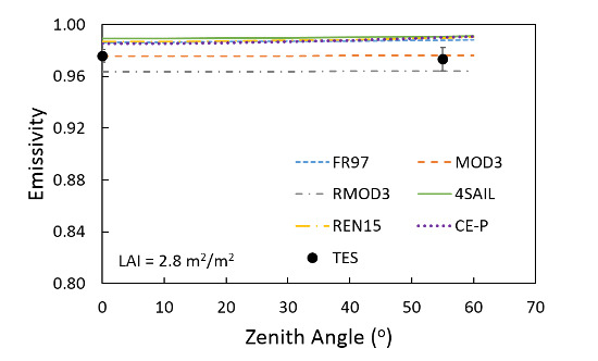
Land surface temperature (LST) is a fundamental physical quantity in a range of different studies, for example in climatological analyses and surface–atmosphere heat flux assessments, especially in heterogeneous and complex surfaces such as vegetated canopies. To obtain accurate LST values, it is important to measure accurately the land surface emissivity (LSE) in the thermal infrared spectrum. In the past decades, different directional emissivity canopy models have been proposed. This paper evaluates six radiative transfer models (FR97, Mod3, Rmod3, 4SAIL, REN15, and CE-P models) through a comparison with in situ emissivity measurements performed using the temperature-emissivity separation (TES) method. The evaluation is done using a single set of rose plants over two different soils with very different spectral behavior. First, using an organic soil, the measurements were done for seven different observation angles, from 0° to 60° in steps of 10°, and for six different values of leaf area index (LAI). Taking into account all LAIs, the bias (and root mean square error, RMSE) obtained were 0.003 (±0.006), −0.004 (±0.005), −0.009 (±0.011), 0.005 (±0.007), 0.004 (±0.007), and 0.005 (±0.007) for FR97, Mod3, Rmod3, 4SAIL, REN 15, and CE-P models, respectively. Second, using an inorganic soil, the measurements were done for six different LAIs but for two different observation angles: 0° and 55°. The bias (and RMSE) obtained were 0.012 (±0.014), 0.004 (±0.007), −0.020 (±0.035), 0.016 (±0.017), 0.013 (±0.015), 0.013 (±0.015) and for FR97, Mod3, Rmod3, 4SAIL, REN15, and CE-P models, respectively. Overall, the Mod3 model appears as the best model in comparison to the TES emissivity reference measurements. Full article
Show Figures

Graphical abstract

24 pages, 7935 KiB  
Article
A New Method for Characterizing NOAA-20/S-NPP VIIRS Thermal Emissive Bands Response Versus Scan Using On-Orbit Pitch Maneuver Data
by Wenhui Wang, Changyong Cao and Slawomir Blonski
Remote Sens. 2019, 11(13), 1624; https://doi.org/10.3390/rs11131624 - 9 Jul 2019
Cited by 7 | Viewed by 3672
Abstract
The on-orbit calibration of Visible Infrared Imaging Radiometer Suite (VIIRS) Thermal Emissive Bands (TEB), onboard the National Oceanic and Atmospheric Administration-20 (NOAA-20) and the Suomi National Polar-orbiting Partnership (S-NPP) satellites, have been stable during nominal operations. However, larger than expected scan angle/scene temperature [...] Read more.
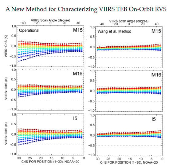
The on-orbit calibration of Visible Infrared Imaging Radiometer Suite (VIIRS) Thermal Emissive Bands (TEB), onboard the National Oceanic and Atmospheric Administration-20 (NOAA-20) and the Suomi National Polar-orbiting Partnership (S-NPP) satellites, have been stable during nominal operations. However, larger than expected scan angle/scene temperature dependent biases, relative to the co-located Cross-track Infrared Sounder (CrIS) observations, were observed in the NOAA-20 longwave infrared (LWIR) bands. The Response Versus Scan (RVS) effect—the variation of instrument reflectance of source radiance with scan angle, is a significant contributor to VIIRS calibration. TEB RVS is characterized using prelaunch test data and verified on-orbit using pitch maneuver data. This study presents a new method that characterizes VIIRS on-orbit TEB RVS at both Earth View (EV) and Space View (SV) scan angles simultaneously. This method was compared with an existing on-orbit RVS method (the Wu et al. method), which derives RVS at EV scan angles using pitch maneuver data and extrapolates SV RVS from EV. The new method derived on-orbit RVS differ from prelaunch values up to 1.0% at the beginning of scan in the NOAA-20 LWIR bands, and ~0.5% in S-NPP M15. VIIRS–CrIS inter-comparison results indicates that the new method derived on-orbit RVS can effectively minimize LWIR scan angle/scene temperature dependent biases, with scan averaged biases reduced from 0.40K to 0.15K for NOAA-20 LWIR bands, and from 0.24K to 0.08K for S-NPP M15. The Wu et al. method can also reduce the scan angle dependent biases, but at the expense of increasing the scene temperature dependent biases. Full article
Show Figures

Graphical abstract

27 pages, 22597 KiB  
Article
Revisiting Pseudo Invariant Calibration Sites (PICS) Over Sand Deserts for Vicarious Calibration of Optical Imagers at 20 km and 100 km Scales
by Cédric Bacour, Xavier Briottet, François-Marie Bréon, Françoise Viallefont-Robinet and Marc Bouvet
Remote Sens. 2019, 11(10), 1166; https://doi.org/10.3390/rs11101166 - 15 May 2019
Cited by 37 | Viewed by 5363
Abstract
In-flight assessment of the radiometric performances of space-borne instruments can be achieved by means of vicarious calibration over Pseudo-Invariant Calibration Sites (PICS). PICS are chosen for the high temporal stability of their surface optical properties combined with a high spatial homogeneity. A first [...] Read more.
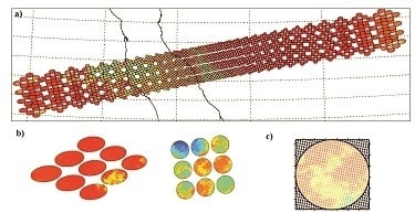
In-flight assessment of the radiometric performances of space-borne instruments can be achieved by means of vicarious calibration over Pseudo-Invariant Calibration Sites (PICS). PICS are chosen for the high temporal stability of their surface optical properties combined with a high spatial homogeneity. A first list of the main desert PIC sites was identified 20 years ago for the calibration of medium/coarse spatial resolution instruments in the solar spectral range (400–2500 nm). They are located in the Saharan desert and in the Arabian Peninsula. Six of them have since been endorsed by the CEOS/WGCV/IVOS as reference Calibration/Validation test sites. In this study, we have revisited the list of desert PIC sites at the global scale with the aim of (1) assessing if these twenty PICS are still “optimal”, in terms of temporal stability and spatial uniformity, and using up-to-date multi-spectral remote sensing data, and (2) identifying new calibration sites distributed over other areas of the world. We verified that the original sites remain very relevant, although alternate locations in their close vicinity have slightly better characteristics. We proposed four additional targets with similar characteristics, some of which may offer easier logistical access. In order to support radiative transfer simulations of satellite sensor measurements over the sites, we assessed the abilities of several semi-empirical models to reproduce the spectro-directional signatures of six IVOS sites and the four new candidate sites, and we derived climatologies of the main atmospheric properties (trace gas column load and aerosol optical depth). Full article
Show Figures

Graphical abstract

11 pages, 1515 KiB  
Letter
VIIRS Nighttime Lights in the Estimation of Cross-Sectional and Time-Series GDP
by Xi Chen and William D. Nordhaus
Remote Sens. 2019, 11(9), 1057; https://doi.org/10.3390/rs11091057 - 5 May 2019
Cited by 89 | Viewed by 9188
Abstract
This study extends previous applications of DMSP OLS nighttime lights data to examine the usefulness of newer VIIRS lights in the estimation of economic activity. Focusing on both US states and metropolitan statistical areas (MSAs), we found that the VIIRS lights are more [...] Read more.
This study extends previous applications of DMSP OLS nighttime lights data to examine the usefulness of newer VIIRS lights in the estimation of economic activity. Focusing on both US states and metropolitan statistical areas (MSAs), we found that the VIIRS lights are more useful in predicting cross-sectional GDP than predicting time-series GDP data. This result is similar to previous findings for DMSP OLS nighttime lights. Additionally, the present analysis shows that high-resolution VIIRS lights provide a better prediction for MSA GDP than for state GDP, which suggests that lights may be more closely related to urban sectors than rural sectors. The results also indicate the importance of considering biases that may arise from different aggregations (the modifiable areal unit problems, MAUP) in applications of nighttime lights in understanding socioeconomic phenomenon. Full article
Show Figures

Figure 1

16 pages, 348 KiB  
Article
Pre-launch Radiometric Characterization of JPSS-2 VIIRS Thermal Emissive Bands
by Jeff McIntire, David Moyer, Hassan Oudrari and Xiaoxiong Xiong
Remote Sens. 2019, 11(6), 732; https://doi.org/10.3390/rs11060732 - 26 Mar 2019
Cited by 4 | Viewed by 3306
Abstract
The Joint Polar Satellite System 2 (JPSS-2) Visible Infrared Imaging Radiometer Suite (VIIRS) is the third in its series of sensors designed to produce high quality data products for environmental and climate data records once launched. To meet this goal, the VIIRS instrument [...] Read more.
The Joint Polar Satellite System 2 (JPSS-2) Visible Infrared Imaging Radiometer Suite (VIIRS) is the third in its series of sensors designed to produce high quality data products for environmental and climate data records once launched. To meet this goal, the VIIRS instrument must be calibrated and characterized prior to launch. A comprehensive test program was conducted at the Raytheon Space and Airborne Systems facility in 2016–2017, including extensive environmental testing. The pre-launch thermal band radiometric performance and stability is the focus of this work including: the evaluation of a number of sensor performance metrics, comparison to the design requirements, and the estimation of uncertainties. Comparisons of the thermal band performance to the earlier Suomi National Polar-orbiting Partnership (SNPP) and JPSS-1 VIIRS instruments as well as the design specifications have shown that JPSS-2 VIIRS exhibits similar performance to its predecessors. The differences of note (decreased blackbody uniformity, reduced dynamic range for bands M15 and M16, and improved performance with respect to striping) are small and not expected to have a significant impact on the science products. Full article
Show Figures

Figure 1

31 pages, 16648 KiB  
Article
An Overview of the Science Performances and Calibration/Validation of Joint Polar Satellite System Operational Products
by Lihang Zhou, Murty Divakarla, Xingpin Liu, Arron Layns and Mitch Goldberg
Remote Sens. 2019, 11(6), 698; https://doi.org/10.3390/rs11060698 - 22 Mar 2019
Cited by 48 | Viewed by 7304
Abstract
The Suomi National Polar-orbiting Partnership (S-NPP) satellite, launched in October 2011, initiated a series of the next-generation weather satellites for the National Oceanic and Atmospheric Administration (NOAA) Joint Polar Satellite System (JPSS) program. The JPSS program at the Center for Satellite Applications and [...] Read more.
The Suomi National Polar-orbiting Partnership (S-NPP) satellite, launched in October 2011, initiated a series of the next-generation weather satellites for the National Oceanic and Atmospheric Administration (NOAA) Joint Polar Satellite System (JPSS) program. The JPSS program at the Center for Satellite Applications and Research (JSTAR) leads the development of the algorithms, the calibration and validation of the products to meet the specified requirements, and long-term science performance monitoring and maintenance. All of the S-NPP products have been validated and are in successful operation. The recently launched JPSS-1 (renamed as NOAA-20) satellite is producing high-quality data products that have been available from S-NPP, along with additional products, as a direct result of the instrument upgrades and science improvements. This paper presents an overview of the JPSS product suite, the performance metrics achieved for the S-NPP, and the utilization of the products by NOAA stakeholders and user agencies worldwide. The status of NOAA-20 science data products and ongoing calibration/validation (Cal/Val) efforts are discussed for user awareness. In addition, operational implementation statuses of JPSS enterprise (multisensor and multiplatform) science algorithms for product generation and science product reprocessing efforts for the S-NPP mission are discussed. Full article
Show Figures

Graphical abstract

2018

Jump to: 2020, 2019, 2017, 2016, 2015

13 pages, 9857 KiB  
Article
Mesospheric Bore Observations Using Suomi-NPP VIIRS DNB during 2013–2017
by Yucheng Su, Jia Yue, Xiao Liu, Steven D. Miller, William C. Straka III, Steven M. Smith, Dong Guo and Shengli Guo
Remote Sens. 2018, 10(12), 1935; https://doi.org/10.3390/rs10121935 - 1 Dec 2018
Cited by 8 | Viewed by 3842
Abstract
This paper reports mesospheric bore events observed by Day/Night Band (DNB) of the Visible/Infrared Imaging Radiometer Suite (VIIRS) on the National Oceanic and Atmospheric Administration/National Aeronautics and Space Administration (NOAA/NASA) Suomi National Polar-orbiting Partnership (NPP) environmental satellite over five years (2013–2017). Two types [...] Read more.
This paper reports mesospheric bore events observed by Day/Night Band (DNB) of the Visible/Infrared Imaging Radiometer Suite (VIIRS) on the National Oceanic and Atmospheric Administration/National Aeronautics and Space Administration (NOAA/NASA) Suomi National Polar-orbiting Partnership (NPP) environmental satellite over five years (2013–2017). Two types of special mesospheric bore events were observed, enabled by the wide field of view of VIIRS: extremely wide bores (>2000 km extension perpendicular to the bore propagation direction), and those exhibiting more than 15 trailing crests and troughs. A mesospheric bore event observed simultaneously from space and ground was investigated in detail. DNB enables the preliminary global observation of mesospheric bores for the first time. DNB mesospheric bores occurred more frequently in March, April and May. Their typical lengths are between 300 km and 1200 km. The occurrence rate of bores at low latitudes is higher than that at middle latitudes. Among the 61 bore events, 39 events occurred in the tropical region (20°S–20°N). The high occurrence rate of mesospheric bores during the spring months in the tropical region coincides with the reported seasonal and latitudinal variations of mesospheric inversion layers. Full article
Show Figures

Figure 1

24 pages, 5939 KiB  
Article
An Overall Assessment of JPSS-2 VIIRS Radiometric Performance Based on Pre-Launch Testing
by Hassan Oudrari, Jeff McIntire, Xiaoxiong Xiong, James Butler, Qiang Ji, Thomas Schwarting and Amit Angal
Remote Sens. 2018, 10(12), 1921; https://doi.org/10.3390/rs10121921 - 30 Nov 2018
Cited by 25 | Viewed by 4162
Abstract
The Visible Infrared Imaging Radiometer Suite (VIIRS) on-board the second Joint Polar Satellite System (JPSS) completed its sensor level testing in February 2018. The JPSS-2 (J2) mission is scheduled to launch in 2022 and will be very similar to its two predecessor missions, [...] Read more.
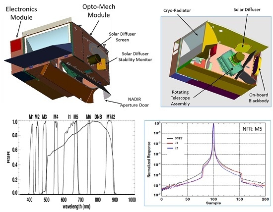
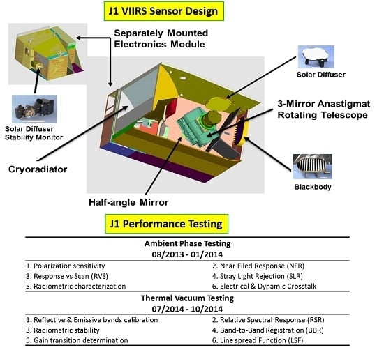
The Visible Infrared Imaging Radiometer Suite (VIIRS) on-board the second Joint Polar Satellite System (JPSS) completed its sensor level testing in February 2018. The JPSS-2 (J2) mission is scheduled to launch in 2022 and will be very similar to its two predecessor missions, the Suomi National Polar-orbiting Partnership (SNPP) mission, launched on 28 October 2011 and JPSS-1 (renamed NOAA-20) launched on 18 November 2017. VIIRS instrument has 22 spectral bands covering the spectrum between 0.4 and 12.6 μm: 14 reflective solar bands (RSB), 7 thermal emissive bands (TEB) and one day-night band (DNB). It is a cross-track scanning radiometer capable of providing global measurements through observations at two spatial resolutions, 375 m and 750 m at nadir for the imaging bands and moderate bands, respectively. This paper will provide an overview of J2 VIIRS characterization methodologies and calibration performance during the pre-launch testing phases performed by the National Aeronautics and Space Administration (NASA) VIIRS Characterization Support Team (VCST) to evaluate the at-launch baseline radiometric performance and generate the parameters needed to populate the sensor data record (SDR) Look-Up-Tables (LUTs). Our analysis results confirmed the good performance of J2 VIIRS, in general as good as previous VIIRS instruments and all non-compliances are expected to have low impact on data quality. Key sensor performance metrics include the signal to noise ratio (SNR), radiance dynamic range, reflective and emissive bands calibration performance, polarization sensitivity, spectral performance, response versus scan-angle (RVS) and scattered light response. A set of performance metrics generated during the pre-launch testing program will be compared to both the SNPP and JPSS-1 VIIRS sensors. Full article
Show Figures

Graphical abstract

19 pages, 13688 KiB  
Article
The Random Forest-Based Method of Fine-Resolution Population Spatialization by Using the International Space Station Nighttime Photography and Social Sensing Data
by Kangning Li, Yunhao Chen and Ying Li
Remote Sens. 2018, 10(10), 1650; https://doi.org/10.3390/rs10101650 - 17 Oct 2018
Cited by 50 | Viewed by 6543
Abstract
Despite the importance of high-resolution population distribution in urban planning, disaster prevention and response, region economic development, and improvement of urban habitant environment, traditional urban investigations mainly focused on large-scale population spatialization by using coarse-resolution nighttime light (NTL) while few efforts were made [...] Read more.
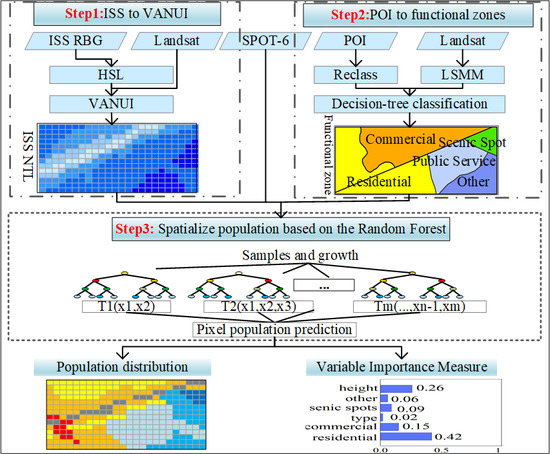
Despite the importance of high-resolution population distribution in urban planning, disaster prevention and response, region economic development, and improvement of urban habitant environment, traditional urban investigations mainly focused on large-scale population spatialization by using coarse-resolution nighttime light (NTL) while few efforts were made to fine-resolution population mapping. To address problems of generating small-scale population distribution, this paper proposed a method based on the Random Forest Regression model to spatialize a 25 m population from the International Space Station (ISS) photography and urban function zones generated from social sensing data—point-of-interest (POI). There were three main steps, namely HSL (hue saturation lightness) transformation and saturation calibration of ISS, generating functional-zone maps based on point-of-interest, and spatializing population based on the Random Forest model. After accuracy assessments by comparing with WorldPop, the proposed method was validated as a qualified method to generate fine-resolution population spatial maps. In the discussion, this paper suggested that without help of auxiliary data, NTL cannot be directly employed as a population indicator at small scale. The Variable Importance Measure of the RF model confirmed the correlation between features and population and further demonstrated that urban functions performed better than LULC (Land Use and Land Cover) in small-scale population mapping. Urban height was also shown to improve the performance of population disaggregation due to its compensation of building volume. To sum up, this proposed method showed great potential to disaggregate fine-resolution population and other urban socio-economic attributes. Full article
Show Figures

Graphical abstract

2017

Jump to: 2020, 2019, 2018, 2016, 2015

644 KiB  
Article
Pre-Launch JPSS-2 VIIRS Response versus Scan Angle Characterization
by Jeff McIntire, David Moyer, Tiejun Chang, Hassan Oudrari and Xiaoxiong Xiong
Remote Sens. 2017, 9(12), 1300; https://doi.org/10.3390/rs9121300 - 12 Dec 2017
Cited by 12 | Viewed by 3900
Abstract
On-orbit whisk-broom sensors have scanning mirror assemblies, whose reflectance variations with scan angle must be characterized prior to launch. One such instrument is the Visible Infrared Imaging Radiometer Suite (VIIRS) onboard the Joint Polar Satellite System 2 (JPSS-2) platform. The scanning optics inside [...] Read more.
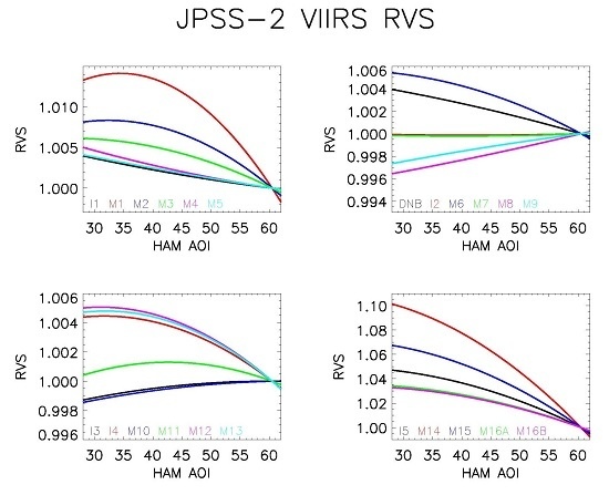
On-orbit whisk-broom sensors have scanning mirror assemblies, whose reflectance variations with scan angle must be characterized prior to launch. One such instrument is the Visible Infrared Imaging Radiometer Suite (VIIRS) onboard the Joint Polar Satellite System 2 (JPSS-2) platform. The scanning optics inside VIIRS includes a four mirror rotating telescope assembly (RTA) and a half angle mirror (HAM), rotating at half the speed of the RTA, which de-rotates the light before it enters the aft-optics assembly. The angle of incidence (AOI) on the HAM varies with scan angle; all of the other optical components in VIIRS have a fixed AOI with scan angle. In general, the reflectance of the HAM will vary with AOI. This parameter is difficult to quantify once in orbit and therefore must be characterized pre-launch. Ground measurements were performed in the summer of 2016 to determine the relative reflectance change of the instrument with scan angle, referred to as the response versus scan angle (RVS). This work will describe the RVS testing performed and the results obtained, including an atmospheric water vapor correction and an uncertainty analysis. Results indicate that the reflectance variation with scan angle is small for spectral bands between 0.4 μ m and 4 μ m (less than 2% over the full range of AOI); in contrast, the reflectance variation is between 3% and 10% for the spectral bands in the 8 μ m to 12 μ m range. Uncertainties are below 0.05% in the reflective solar spectral region and below 0.26% in the thermal emissive spectral region. Comparisons to previous VIIRS builds (on the SNPP and JPSS-1 satellites) show comparable performance. Full article
Show Figures

Graphical abstract

3998 KiB  
Article
Assessment of the NOAA S-NPP VIIRS Geolocation Reprocessing Improvements
by Wenhui Wang, Changyong Cao, Yan Bai, Slawomir Blonski and Mitchell A. Schull
Remote Sens. 2017, 9(10), 974; https://doi.org/10.3390/rs9100974 - 21 Sep 2017
Cited by 30 | Viewed by 6353
Abstract
Long-term time series analysis requires consistent data records from satellites. The Visible Infrared Imaging Radiometer Suite (VIIRS) onboard the Suomi National Polar orbiting Partner (S-NPP) satellite launched in 2011 requires a major effort to produce consistently calibrated sensor data records (SDR). Accurate VIIRS [...] Read more.
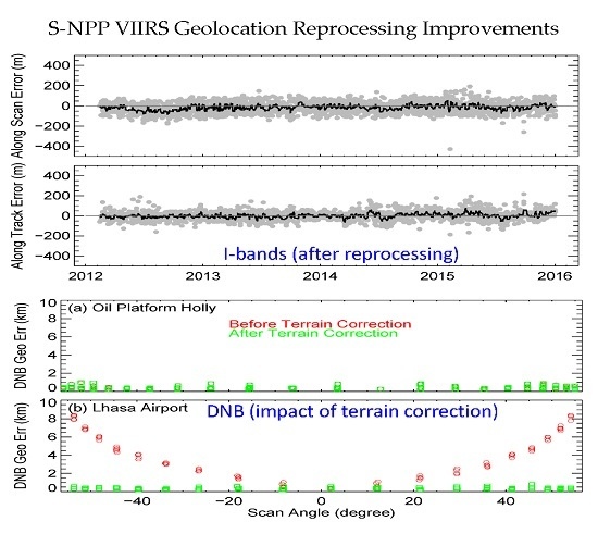
Long-term time series analysis requires consistent data records from satellites. The Visible Infrared Imaging Radiometer Suite (VIIRS) onboard the Suomi National Polar orbiting Partner (S-NPP) satellite launched in 2011 requires a major effort to produce consistently calibrated sensor data records (SDR). Accurate VIIRS geolocation products are critical to other VIIRS products and products from other instruments on the S-NPP satellite. This paper presents methods for assessing major improvements to the VIIRS geolocation products in the ongoing National Oceanic and Atmospheric Administration (NOAA)/Center for Satellite Applications and Research (STAR) reprocessing that incorporates all corrections in calibration parameters and SDR algorithms since launch to present. In this study, we analyzed the history of VIIRS geometric calibration parameter updates to identify optimal parameters to account for geolocation errors in the early days of the mission. A sample area located in North Western Africa was selected for validation purposes after analyzing global VIIRS and Landsat control point matching results. Geolocation products over the study region were reprocessed and I-bands/M-bands geolocation improvements were characterized by comparing geolocation errors before and after the reprocessing. Our results indicate that all short-term geolocation anomalies before the latest operational geometric calibration parameter update on 22 August 2013 were effectively minimized after reprocessing, with geolocation errors reduced from −47.1 ± 83.8 m to −23.3 ± 51.1 m (along scan) and from −15.6 ± 43.6 m to −5.9 ± 37.7 m (along track). Terrain correction for the VIIRS Day-Night-Band (DNB) was not implemented in the NOAA operational processing until 22 May 2015. In the reprocessing, it will be implemented to the entire DNB geolocation data record. DNB reprocessing improvement due to this implementation was evaluated using nighttime observations over point sources at sea level and over high altitude. Our results show that the implementation of terrain correction will reduce DNB geolocation errors at off-nadir high elevation locations from up to 9 km to ~0.5 pixel (0.375 km), comparable to those at sea level site. The reprocessed geolocation dataset will be distributed online for end-users to access. Full article
Show Figures

Graphical abstract

2016

Jump to: 2020, 2019, 2018, 2017, 2015

2332 KiB  
Article
Using Ground Targets to Validate S-NPP VIIRS Day-Night Band Calibration
by Xuexia Chen, Aisheng Wu, Xiaoxiong Xiong, Ning Lei, Zhipeng Wang and Kwofu Chiang
Remote Sens. 2016, 8(12), 984; https://doi.org/10.3390/rs8120984 - 30 Nov 2016
Cited by 6 | Viewed by 5748
Abstract
In this study, the observations from S-NPP VIIRS Day-Night band (DNB) and Moderate resolution bands (M bands) of Libya 4 and Dome C over the first four years of the mission are used to assess the DNB low gain calibration stability. The Sensor [...] Read more.
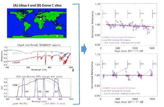
In this study, the observations from S-NPP VIIRS Day-Night band (DNB) and Moderate resolution bands (M bands) of Libya 4 and Dome C over the first four years of the mission are used to assess the DNB low gain calibration stability. The Sensor Data Records produced by NASA Land Product Evaluation and Algorithm Testing Element (PEATE) are acquired from nearly nadir overpasses for Libya 4 desert and Dome C snow surfaces. A kernel-driven bidirectional reflectance distribution function (BRDF) correction model is used for both Libya 4 and Dome C sites to correct the surface BRDF influence. At both sites, the simulated top-of-atmosphere (TOA) DNB reflectances based on SCIAMACHY spectral data are compared with Land PEATE TOA reflectances based on modulated Relative Spectral Response (RSR). In the Libya 4 site, the results indicate a decrease of 1.03% in Land PEATE TOA reflectance and a decrease of 1.01% in SCIAMACHY derived TOA reflectance over the period from April 2012 to January 2016. In the Dome C site, the decreases are 0.29% and 0.14%, respectively. The consistency between SCIAMACHY and Land PEATE data trends is good. The small difference between SCIAMACHY and Land PEATE derived TOA reflectances could be caused by changes in the surface targets, atmosphere status, and on-orbit calibration. The reflectances and radiances of Land PEATE DNB are also compared with matching M bands and the integral M bands based on M4, M5, and M7. The fitting trends of the DNB to integral M bands ratios indicate a 0.75% decrease at the Libya 4 site and a 1.89% decrease at the Dome C site. Part of the difference is due to an insufficient number of sampled bands available within the DNB wavelength range. The above results indicate that the Land PEATE VIIRS DNB product is accurate and stable. The methods used in this study can be used on other satellite instruments to provide quantitative assessments for calibration stability. Full article
Show Figures

Graphical abstract

14134 KiB  
Article
Retrieval of Leaf Area Index (LAI) and Fraction of Absorbed Photosynthetically Active Radiation (FAPAR) from VIIRS Time-Series Data
by Zhiqiang Xiao, Shunlin Liang, Tongtong Wang and Bo Jiang
Remote Sens. 2016, 8(4), 351; https://doi.org/10.3390/rs8040351 - 21 Apr 2016
Cited by 28 | Viewed by 7609
Abstract
Long-term high-quality global leaf area index (LAI) and fraction of absorbed photosynthetically active radiation (FAPAR) products are urgently needed for the study of global change, climate modeling, and many other problems. As the successor of the Moderate Resolution Imaging Spectroradiometer (MODIS) sensor, the [...] Read more.
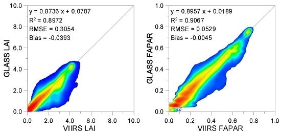
Long-term high-quality global leaf area index (LAI) and fraction of absorbed photosynthetically active radiation (FAPAR) products are urgently needed for the study of global change, climate modeling, and many other problems. As the successor of the Moderate Resolution Imaging Spectroradiometer (MODIS) sensor, the Visible Infrared Imaging Radiometer Suite (VIIRS) will continue to provide global environmental measurements. This paper aims to generate longer time series Global LAnd Surface Satellite (GLASS) LAI and FAPAR products after the era of the MODIS sensor. To ensure spatial and temporal consistencies between GLASS LAI/FAPAR values retrieved from different satellite observations, the GLASS LAI/FAPAR retrieval algorithms were adapted in this study to retrieve LAI and FAPAR values from VIIRS surface reflectance time-series data. After reprocessing of the VIIRS surface reflectance to remove remaining effects of cloud contamination and other factors, a database generated from the GLASS LAI product and the reprocessed VIIRS surface reflectance for all Benchmark Land Multisite Analysis and Intercomparison of Products (BELMANIP) sites was used to train general regression neural networks (GRNNs). The reprocessed VIIRS surface reflectance data from an entire year were entered into the trained GRNNs to estimate the one-year LAI values, which were then used to calculate FAPAR values. A cross-comparison indicates that the LAI and FAPAR values retrieved from VIIRS surface reflectance were generally consistent with the GLASS, MODIS and Geoland2/BioPar version 1 (GEOV1) LAI/FAPAR values in their spatial patterns. The LAI/FAPAR values retrieved from VIIRS surface reflectance achieved good agreement with the GLASS LAI/FAPAR values (R2 = 0.8972 and RMSE = 0.3054; and R2 = 0.9067 and RMSE = 0.0529, respectively). However, validation of the LAI and FAPAR values derived from VIIRS reflectance data is now limited by the scarcity of LAI/FAPAR ground measurements. Full article
Show Figures

Graphical abstract

2127 KiB  
Article
Spectral Dependent Degradation of the Solar Diffuser on Suomi-NPP VIIRS Due to Surface Roughness-Induced Rayleigh Scattering
by Xi Shao, Changyong Cao and Tung-Chang Liu
Remote Sens. 2016, 8(3), 254; https://doi.org/10.3390/rs8030254 - 17 Mar 2016
Cited by 34 | Viewed by 8207
Abstract
The Visible Infrared Imaging Radiometer Suite (VIIRS) onboard Suomi National Polar Orbiting Partnership (SNPP) uses a solar diffuser (SD) as its radiometric calibrator for the reflective solar band calibration. The SD is made of Spectralon™ (one type of fluoropolymer) and was chosen because [...] Read more.
The Visible Infrared Imaging Radiometer Suite (VIIRS) onboard Suomi National Polar Orbiting Partnership (SNPP) uses a solar diffuser (SD) as its radiometric calibrator for the reflective solar band calibration. The SD is made of Spectralon™ (one type of fluoropolymer) and was chosen because of its controlled reflectance in the Visible/Near-Infrared/Shortwave-Infrared region and its near-Lambertian reflectance property. On-orbit changes in VIIRS SD reflectance as monitored by the Solar Diffuser Stability Monitor showed faster degradation of SD reflectance for 0.4 to 0.6 µm channels than the longer wavelength channels. Analysis of VIIRS SD reflectance data show that the spectral dependent degradation of SD reflectance in short wavelength can be explained with a SD Surface Roughness (length scale << wavelength) based Rayleigh Scattering (SRRS) model due to exposure to solar UV radiation and energetic particles. The characteristic length parameter of the SD surface roughness is derived from the long term reflectance data of the VIIRS SD and it changes at approximately the tens of nanometers level over the operational period of VIIRS. This estimated roughness length scale is consistent with the experimental result from radiation exposure of a fluoropolymer sample and validates the applicability of the Rayleigh scattering-based model. The model is also applicable to explaining the spectral dependent degradation of the SDs on other satellites. This novel approach allows us to better understand the physical processes of the SD degradation, and is complementary to previous mathematics based models. Full article
Show Figures

Graphical abstract

3509 KiB  
Article
Preliminary Inter-Comparison between AHI, VIIRS and MODIS Clear-Sky Ocean Radiances for Accurate SST Retrievals
by Xingming Liang, Alexander Ignatov, Maxim Kramar and Fangfang Yu
Remote Sens. 2016, 8(3), 203; https://doi.org/10.3390/rs8030203 - 1 Mar 2016
Cited by 21 | Viewed by 6784
Abstract
Clear-sky brightness temperatures (BT) in five bands of the Advanced Himawari Imager (AHI; flown onboard Himawari-8 satellite) centered at 3.9, 8.6, 10.4, 11.2, and 12.3 µm (denoted by IR37, IR86, IR10, IR11, and IR12, respectively) are used in the NOAA Advanced Clear-Sky Processor [...] Read more.
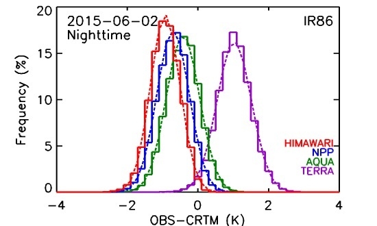
Clear-sky brightness temperatures (BT) in five bands of the Advanced Himawari Imager (AHI; flown onboard Himawari-8 satellite) centered at 3.9, 8.6, 10.4, 11.2, and 12.3 µm (denoted by IR37, IR86, IR10, IR11, and IR12, respectively) are used in the NOAA Advanced Clear-Sky Processor for Oceans (ACSPO) sea surface temperature (SST) retrieval system. Here, AHI BTs are preliminarily evaluated for stability and consistency with the corresponding VIIRS and MODIS BTs, using the sensor observation minus model simulation (O-M) biases and corresponding double differences. The objective is to ensure accurate and consistent SST products from the polar and geo sensors, and to prepare for the launch of the GOES-R satellite in 2016. All five AHI SST bands are found to be largely in-family with their polar counterparts, but biased low relative to the VIIRS and MODIS (which, in turn, were found to be stable and consistent, except for Terra IR86, which is biased high by 1.5 K). The negative biases are larger in IR37 and IR12 (up to ~−0.5 K), followed by the three remaining longwave IR bands IR86, IR10, and IR11 (from −0.3 to −0.4 K). These negative biases may be in part due to the uncertainties in AHI calibration and characterization, although uncertainties in the coefficients of the Community Radiative Transfer Model (CRTM, used to generate the “M” term) may also contribute. Work is underway to add AHI analyses in the NOAA Monitoring of IR Clear-Sky Radiances over Oceans for SST (MICROS) system and improve AHI BTs by collaborating with the sensor calibration and CRTM teams. The Advanced Baseline Imager (ABI) analyses will be also added in MICROS when GOES-R is launched in late 2016 and the ABI IR data become available. Full article
Show Figures

Graphical abstract

3821 KiB  
Review
VIIRS Reflective Solar Bands Calibration Progress and Its Impact on Ocean Color Products
by Junqiang Sun and Menghua Wang
Remote Sens. 2016, 8(3), 194; https://doi.org/10.3390/rs8030194 - 27 Feb 2016
Cited by 46 | Viewed by 6468
Abstract
The radiometric calibration for the reflective solar bands (RSB) of the Visible Infrared Imaging Radiometer Suite (VIIRS) on board the Suomi National Polar-orbiting Partnership (SNPP) platform has reached a mature stage after four years since its launch. The characterization of the vignetting effect [...] Read more.
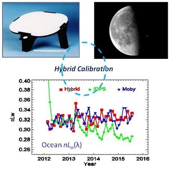
The radiometric calibration for the reflective solar bands (RSB) of the Visible Infrared Imaging Radiometer Suite (VIIRS) on board the Suomi National Polar-orbiting Partnership (SNPP) platform has reached a mature stage after four years since its launch. The characterization of the vignetting effect of the attenuation screens, the bidirectional reflectance factor of the solar diffuser, the degradation performance of the solar diffuser, and the calibration coefficient of the RSB have all been made robust. Additional investigations into the time-dependent out-of-band relative spectral response and the solar diffuser degradation non-uniformity effect have led to newer insights. In particular, it has been demonstrated that the solar diffuser (SD) degradation non-uniformity effect induces long-term bias in the SD-calibration result. A mitigation approach, the so-called Hybrid Method, incorporating lunar-based calibration results, successfully restores the calibration to achieve ~0.2% level accuracy. The successfully calibrated RSB data record significantly impacts the ocean color products, whose stringent requirements are especially sensitive to calibration accuracy, and helps the ocean color products to reach maturity. Full article
Show Figures

Graphical abstract

2152 KiB  
Article
Radiometric Inter-Calibration between Himawari-8 AHI and S-NPP VIIRS for the Solar Reflective Bands
by Fangfang Yu and Xiangqian Wu
Remote Sens. 2016, 8(3), 165; https://doi.org/10.3390/rs8030165 - 23 Feb 2016
Cited by 57 | Viewed by 10042
Abstract
The Advanced Himawari Imager (AHI) on-board Himawari-8, which was launched on 7 October 2014, is the first geostationary instrument housed with a solar diffuser to provide accurate onboard calibrated data for the visible and near-infrared (VNIR) bands. In this study, the Ray-matching and [...] Read more.
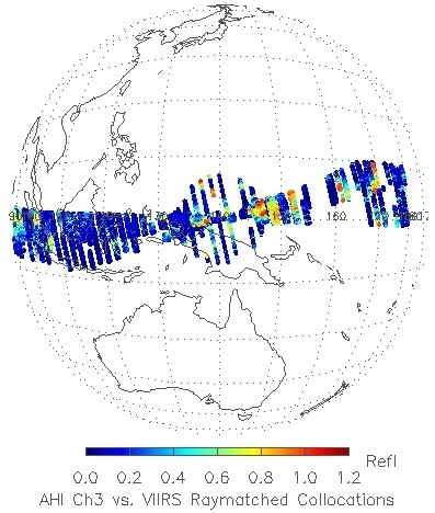
The Advanced Himawari Imager (AHI) on-board Himawari-8, which was launched on 7 October 2014, is the first geostationary instrument housed with a solar diffuser to provide accurate onboard calibrated data for the visible and near-infrared (VNIR) bands. In this study, the Ray-matching and collocated Deep Convective Cloud (DCC) methods, both of which are based on incidently collocated homogeneous pairs between AHI and Suomi NPP (S-NPP) Visible Infrared Imaging Radiometer Suite (VIIRS), are used to evaluate the calibration difference between these two instruments. While the Ray-matching method is used to examine the reflectance difference over the all-sky collocations with similar viewing and illumination geometries, the near lambertian collocated DCC pxiels are used to examine the difference for the median or high reflectance scenes. Strong linear relationships between AHI and VIIRS can be found at all the paired AHI and VIIRS bands. Results of both methods indicate that AHI radiometric calibration accuracy agrees well with VIIRS data within 5% for B1-4 and B6 at mid and high reflectance scenes, while AHI B5 is generally brighter than VIIRS by ~6%–8%. No apparent East-West viewing angle dependent calibration difference can be found at all the VNIR bands. Compared to the Ray-matching method, the collocated DCC method provides less uncertainty of inter-calibration results at near-infrared (NIR) bands. As AHI has similar optics and calibration designs to the GOES-R Advanced Baseline Imager (ABI), which is currently scheduled to launch in fall 2016, the on-orbit AHI data provides a unique opportunity to develop, test and examine the cal/val tools developed for ABI. Full article
Show Figures

Graphical abstract

6170 KiB  
Article
Evaluation of VIIRS and MODIS Thermal Emissive Band Calibration Stability Using Ground Target
by Sriharsha Madhavan, Jake Brinkmann, Brian N. Wenny, Aisheng Wu and Xiaoxiong Xiong
Remote Sens. 2016, 8(2), 158; https://doi.org/10.3390/rs8020158 - 19 Feb 2016
Cited by 18 | Viewed by 7033
Abstract
The S-NPP Visible Infrared Imaging Radiometer Suite (VIIRS) instrument, a polar orbiting Earth remote sensing instrument built using a strong MODIS background, employs a similarly designed on-board calibrating source—a V-grooved blackbody for the Thermal Emissive Bands (TEB). The central wavelengths of most VIIRS [...] Read more.
The S-NPP Visible Infrared Imaging Radiometer Suite (VIIRS) instrument, a polar orbiting Earth remote sensing instrument built using a strong MODIS background, employs a similarly designed on-board calibrating source—a V-grooved blackbody for the Thermal Emissive Bands (TEB). The central wavelengths of most VIIRS TEBs are very close to those of MODIS with the exception of the 10.7 µm channel. To ensure the long term continuity of climate data records derived using VIIRS and MODIS TEB, it is necessary to assess any systematic differences between the two instruments, including scenes with temperatures significantly lower than blackbody operating temperatures at approximately 290 K. Previous work performed by the MODIS Characterization Support Team (MCST) at NASA/GSFC used the frequent observations of the Dome Concordia site located in Antarctica to evaluate the calibration stability and consistency of Terra and Aqua MODIS over the mission lifetime. The near-surface temperature measurements from an automatic weather station (AWS) provide a direct reference useful for tracking the stability and determining the relative bias between the two MODIS instruments. In this study, the same technique is applied to the VIIRS TEB and the results are compared with those from the matched MODIS TEB. The results of this study show a small negative bias when comparing the matching VIIRS and Aqua MODIS TEB, implying a higher brightness temperature for S-VIIRS at the cold end. Statistically no significant drift is observed for VIIRS TEB performance over the first 3.5 years of the mission. Full article
Show Figures

Graphical abstract

3587 KiB  
Article
The Potential of Autonomous Ship-Borne Hyperspectral Radiometers for the Validation of Ocean Color Radiometry Data
by Vittorio E. Brando, Jenny L. Lovell, Edward A. King, David Boadle, Roger Scott and Thomas Schroeder
Remote Sens. 2016, 8(2), 150; https://doi.org/10.3390/rs8020150 - 16 Feb 2016
Cited by 44 | Viewed by 8181
Abstract
Calibration and validation of satellite observations are essential and on-going tasks to ensure compliance with mission accuracy requirements. An automated above water hyperspectral radiometer significantly augmented Australia’s ability to contribute to global and regional ocean color validation and algorithm design activities. The hyperspectral [...] Read more.
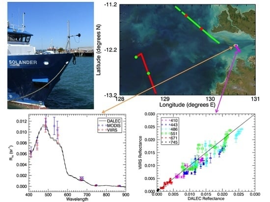
Calibration and validation of satellite observations are essential and on-going tasks to ensure compliance with mission accuracy requirements. An automated above water hyperspectral radiometer significantly augmented Australia’s ability to contribute to global and regional ocean color validation and algorithm design activities. The hyperspectral data can be re-sampled for comparison with current and future sensor wavebands. The continuous spectral acquisition along the ship track enables spatial resampling to match satellite footprint. This study reports spectral comparisons of the radiometer data with Visible Infrared Imaging Radiometer Suite (VIIRS) and Moderate Resolution Imaging Spectroradiometer (MODIS)-Aqua for contrasting water types in tropical waters off northern Australia based on the standard NIR atmospheric correction implemented in SeaDAS. Consistent match-ups are shown for transects of up to 50 km over a range of reflectance values. The MODIS and VIIRS satellite reflectance data consistently underestimated the in situ spectra in the blue with a bias relative to the “dynamic above water radiance and irradiance collector” (DALEC) at 443 nm ranging from 9.8 × 10⁻⁴ to 3.1 × 10⁻³ sr−1. Automated acquisition has produced good quality data under standard operating and maintenance procedures. A sensitivity analysis explored the effects of some assumptions in the data reduction methods, indicating the need for a comprehensive investigation and quantification of each source of uncertainty in the estimate of the DALEC reflectances. Deployment on a Research Vessel provides the potential for the radiometric data to be combined with other sampling and observational activities to contribute to algorithm development in the wider bio-optical research community. Full article
Show Figures

Graphical abstract

4758 KiB  
Article
Assessing the Effects of Suomi NPP VIIRS M15/M16 Detector Radiometric Stability and Relative Spectral Response Variation on Striping
by Zhuo Wang and Changyong Cao
Remote Sens. 2016, 8(2), 145; https://doi.org/10.3390/rs8020145 - 15 Feb 2016
Cited by 48 | Viewed by 6646
Abstract
Modern satellite radiometers have many detectors with different relative spectral response (RSR). Effect of RSR differences on striping and the root cause of striping in sensor data record (SDR) radiance and brightness temperature products have not been well studied. A previous study used [...] Read more.
Modern satellite radiometers have many detectors with different relative spectral response (RSR). Effect of RSR differences on striping and the root cause of striping in sensor data record (SDR) radiance and brightness temperature products have not been well studied. A previous study used MODTRAN radiative transfer model (RTM) to analyze striping. In this study, we make efforts to find the possible root causes of striping. Line-by-Line RTM (LBLRTM) is used to evaluate the effect of RSR difference on striping and the atmospheric dependency for VIIRS bands M15 and M16. The results show that previous study using MODTRAN is repeatable: the striping is related to the difference between band-averaged and detector-level RSR, and the BT difference has some atmospheric dependency. We also analyzed VIIRS earth view (EV) data with several striping index methods. Since the EV data is complex, we further analyze the onboard calibration data. Analysis of Variance (ANOVA) test shows that the noise along track direction is the major reason for striping. We also found evidence of correlation between solar diffuser (SD) and blackbody (BB) for detector 1 in M15. Digital Count Restoration (DCR) and detector instability are possibly related to the striping in SD and EV data, but further analysis is needed. These findings can potentially lead to further SDR processing improvements. Full article
Show Figures

Graphical abstract

6639 KiB  
Article
JPSS-1 VIIRS Pre-Launch Response Versus Scan Angle Testing and Performance
by David Moyer, Jeff McIntire, Hassan Oudrari, James McCarthy, Xiaoxiong Xiong and Frank De Luccia
Remote Sens. 2016, 8(2), 141; https://doi.org/10.3390/rs8020141 - 12 Feb 2016
Cited by 33 | Viewed by 5712
Abstract
The Visible Infrared Imaging Radiometer Suite (VIIRS) instruments on-board both the Suomi National Polar-orbiting Partnership (S-NPP) and the first Joint Polar Satellite System (JPSS-1) spacecraft, with launch dates of October 2011 and December 2016 respectively, are cross-track scanners with an angular swath of [...] Read more.
The Visible Infrared Imaging Radiometer Suite (VIIRS) instruments on-board both the Suomi National Polar-orbiting Partnership (S-NPP) and the first Joint Polar Satellite System (JPSS-1) spacecraft, with launch dates of October 2011 and December 2016 respectively, are cross-track scanners with an angular swath of ±56.06°. A four-mirror Rotating Telescope Assembly (RTA) is used for scanning combined with a Half Angle Mirror (HAM) that directs light exiting from the RTA into the aft-optics. It has 14 Reflective Solar Bands (RSBs), seven Thermal Emissive Bands (TEBs) and a panchromatic Day Night Band (DNB). There are three internal calibration targets, the Solar Diffuser, the BlackBody and the Space View, that have fixed scan angles within the internal cavity of VIIRS. VIIRS has calibration requirements of 2% on RSB reflectance and as tight as 0.4% on TEB radiance that requires the sensor’s gain change across the scan or Response Versus Scan angle (RVS) to be well quantified. A flow down of the top level calibration requirements put constraints on the characterization of the RVS to 0.2%–0.3% but there are no specified limitations on the magnitude of response change across scan. The RVS change across scan angle can vary significantly between bands with the RSBs having smaller changes of ~2% and some TEBs having ~10% variation. Within a band, the RVS has both detector and HAM side dependencies that vary across scan. Errors in the RVS characterization will contribute to image banding and striping artifacts if their magnitudes are above the noise level of the detectors. The RVS was characterized pre-launch for both S-NPP and JPSS-1 VIIRS and a comparison of the RVS curves between these two sensors will be discussed. Full article
Show Figures

Graphical abstract

2828 KiB  
Article
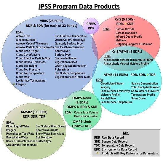
An Overview of the Joint Polar Satellite System (JPSS) Science Data Product Calibration and Validation
by Lihang Zhou, Murty Divakarla and Xingpin Liu
Remote Sens. 2016, 8(2), 139; https://doi.org/10.3390/rs8020139 - 8 Feb 2016
Cited by 47 | Viewed by 9160
Abstract
The Joint Polar Satellite System (JPSS) will launch its first JPSS-1 satellite in early 2017. The JPSS-1 and follow-on satellites will carry aboard an array of instruments including the Visible Infrared Imaging Radiometer Suite (VIIRS), the Cross-track Infrared Sounder (CrIS), the Advanced Technology [...] Read more.
The Joint Polar Satellite System (JPSS) will launch its first JPSS-1 satellite in early 2017. The JPSS-1 and follow-on satellites will carry aboard an array of instruments including the Visible Infrared Imaging Radiometer Suite (VIIRS), the Cross-track Infrared Sounder (CrIS), the Advanced Technology Microwave Sounder (ATMS), and the Ozone Mapping and Profiler Suite (OMPS). These instruments are similar to the instruments currently operating on the Suomi National Polar-orbiting Partnership (S-NPP) satellite. In preparation for the JPSS-1 launch, the JPSS program at the Center for Satellite Applications and Research (JSTAR) Calibration/Validation (Cal/Val) teams, have laid out the Cal/Val plans to oversee JPSS-1 science products’ algorithm development efforts, verification and characterization of these algorithms during the pre-launch period, calibration and validation of the products during post-launch, and long-term science maintenance (LTSM). In addition, the team has developed the necessary schedules, deliverables and infrastructure for routing JPSS-1 science product algorithms for operational implementation. This paper presents an overview of these efforts. In addition, this paper will provide insight into the processes of both adapting S-NPP science products for JPSS-1 and performing upgrades for enterprise solutions, and will discuss Cal/Val processes and quality assurance procedures. Full article
Show Figures

Graphical abstract

9149 KiB  
Article
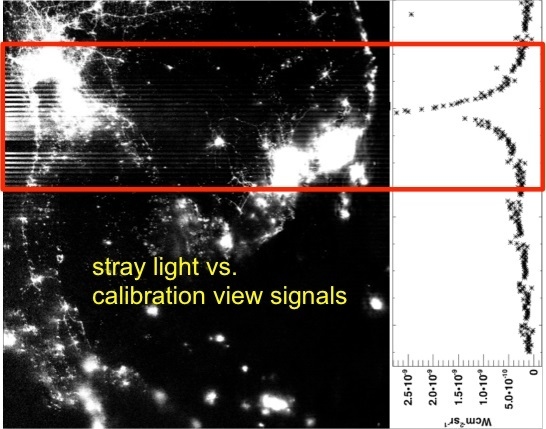
Soumi NPP VIIRS Day/Night Band Stray Light Characterization and Correction Using Calibration View Data
by Shihyan Lee and Changyong Cao
Remote Sens. 2016, 8(2), 138; https://doi.org/10.3390/rs8020138 - 8 Feb 2016
Cited by 34 | Viewed by 8027
Abstract
The Soumi NPP VIIRS Day/Night Band (DNB) nighttime imagery quality is affected by stray light contamination. In this study, we examined the relationship between the Earth scene stray light and the signals in VIIRS’s calibrators to better understand stray light characteristics and to [...] Read more.
The Soumi NPP VIIRS Day/Night Band (DNB) nighttime imagery quality is affected by stray light contamination. In this study, we examined the relationship between the Earth scene stray light and the signals in VIIRS’s calibrators to better understand stray light characteristics and to improve upon the current correction method. Our analyses showed the calibrator signal to be highly predictive of Earth scene stray light and can provide additional stray light characteristics that are difficult to obtain from Earth scene data alone. In the current stray light correction regions (mid-to-high latitude), the stray light onset angles can be tracked by calibration view data to reduce correction biases. In the southern hemisphere, it is possible to identify the angular extent of the additional stray light feature in the calibration view data and develop a revised correction method to remove the additional stray light occurring during the southern hemisphere springtime. Outside of current stray light correction region, the analysis of calibration view data indicated occasional stray light contamination at low latitude and possible background biases caused by Moon illumination. As stray light affects a significant portion of nighttime scenes, further refinement in characterization and correction is important to ensure VIIRS DNB imagery quality for Soumi NPP and future missions. Full article
Show Figures

Graphical abstract

307 KiB  
Review
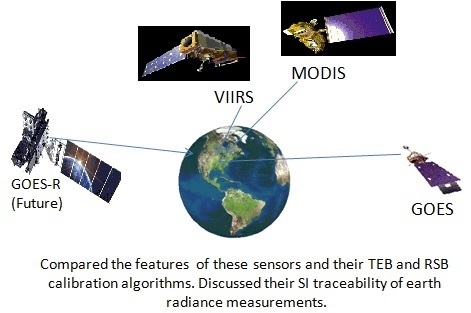
Comparison of the Calibration Algorithms and SI Traceability of MODIS, VIIRS, GOES, and GOES-R ABI Sensors
by Raju Datla, Xi Shao, Changyong Cao and Xiangqian Wu
Remote Sens. 2016, 8(2), 126; https://doi.org/10.3390/rs8020126 - 6 Feb 2016
Cited by 44 | Viewed by 7836
Abstract
The radiometric calibration equations for the thermal emissive bands (TEB) and the reflective solar bands (RSB) measurements of the earth scenes by the polar satellite sensors, (Terra and Aqua) MODIS and Suomi NPP (VIIRS), and geostationary sensors, GOES Imager and the GOES-R Advanced [...] Read more.
The radiometric calibration equations for the thermal emissive bands (TEB) and the reflective solar bands (RSB) measurements of the earth scenes by the polar satellite sensors, (Terra and Aqua) MODIS and Suomi NPP (VIIRS), and geostationary sensors, GOES Imager and the GOES-R Advanced Baseline Imager (ABI) are analyzed towards calibration algorithm harmonization on the basis of SI traceability which is one of the goals of the NOAA National Calibration Center (NCC). One of the overarching goals of NCC is to provide knowledge base on the NOAA operational satellite sensors and recommend best practices for achieving SI traceability for the radiance measurements on-orbit. As such, the calibration methodologies of these satellite optical sensors are reviewed in light of the recommended practice for radiometric calibration at the National Institute of Standards and Technology (NIST). The equivalence of some of the spectral bands in these sensors for their end products is presented. The operational and calibration features of the sensors for on-orbit observation of radiance are also compared in tabular form. This review is also to serve as a quick cross reference to researchers and analysts on how the observed signals from these sensors in space are converted to radiances. Full article
Show Figures

Graphical abstract

5835 KiB  
Article
Assessment of S-NPP VIIRS On-Orbit Radiometric Calibration and Performance
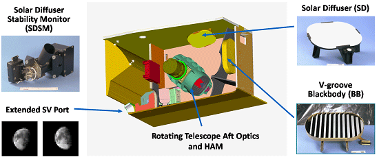
by Xiaoxiong Xiong, James Butler, Kwofu Chiang, Boryana Efremova, Jon Fulbright, Ning Lei, Jeff McIntire, Hassan Oudrari, Zhipeng Wang and Aisheng Wu
Remote Sens. 2016, 8(2), 84; https://doi.org/10.3390/rs8020084 - 23 Jan 2016
Cited by 47 | Viewed by 7169
Abstract
The VIIRS instrument on board the S-NPP spacecraft has successfully operated for more than four years since its launch in October 2011. Many VIIRS environmental data records (EDR) have been continuously generated from its sensor data records (SDR) with improved quality, enabling a [...] Read more.
The VIIRS instrument on board the S-NPP spacecraft has successfully operated for more than four years since its launch in October 2011. Many VIIRS environmental data records (EDR) have been continuously generated from its sensor data records (SDR) with improved quality, enabling a wide range of applications in support of users in both the operational and research communities. This paper provides a brief review of sensor on-orbit calibration methodologies for both the reflective solar bands (RSB) and the thermal emissive bands (TEB) and an overall assessment of their on-orbit radiometric performance using measurements from instrument on-board calibrators (OBC), as well as regularly scheduled lunar observations. It describes and illustrates changes made and to be made for calibration and data quality improvements. Throughout the mission, all of the OBC have continued to operate and function normally, allowing critical calibration parameters used in the data production systems to be derived and updated. The temperatures of the on-board blackbody (BB) and the cold focal plane assemblies are controlled with excellent stability. Despite large optical throughput degradation discovered shortly after launch in several near- and short-wave infrared spectral bands and strong wavelength-dependent solar diffuser degradation, the VIIRS overall performance has continued to meet its design requirements. Also discussed in this paper are challenging issues identified and efforts to be made to further enhance the sensor calibration and characterization, thereby maintaining or improving data quality. Full article
Show Figures

Graphical abstract

5082 KiB  
Article
Improved VIIRS and MODIS SST Imagery
by Irina Gladkova, Alexander Ignatov, Fazlul Shahriar, Yury Kihai, Don Hillger and Boris Petrenko
Remote Sens. 2016, 8(1), 79; https://doi.org/10.3390/rs8010079 - 21 Jan 2016
Cited by 27 | Viewed by 10879
Abstract
Moderate Resolution Imaging Spectroradiometers (MODIS) and Visible Infrared Imaging Radiometer Suite (VIIRS) radiometers, flown onboard Terra/Aqua and Suomi National Polar-orbiting Partnership (S-NPP)/Joint Polar Satellite System (JPSS) satellites, are capable of providing superior sea surface temperature (SST) imagery. However, the swath data of these [...] Read more.
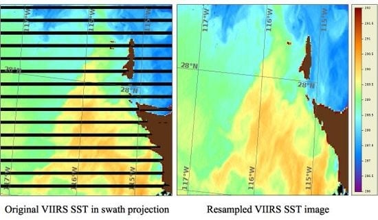
Moderate Resolution Imaging Spectroradiometers (MODIS) and Visible Infrared Imaging Radiometer Suite (VIIRS) radiometers, flown onboard Terra/Aqua and Suomi National Polar-orbiting Partnership (S-NPP)/Joint Polar Satellite System (JPSS) satellites, are capable of providing superior sea surface temperature (SST) imagery. However, the swath data of these multi-detector sensors are subject to several artifacts including bow-tie distortions and striping, and require special pre-processing steps. VIIRS additionally does two irreversible data reduction steps onboard: pixel aggregation (to reduce resolution changes across the swath) and pixel deletion, which complicate both bow-tie correction and destriping. While destriping was addressed elsewhere, this paper describes an algorithm, adopted in the National Oceanic and Atmospheric Administration (NOAA) Advanced Clear-Sky Processor for Oceans (ACSPO) SST system, to minimize the bow-tie artifacts in the SST imagery and facilitate application of the pattern recognition algorithms for improved separation of ocean from cloud and mapping fine SST structure, especially in the dynamic, coastal and high-latitude regions of the ocean. The algorithm is based on a computationally fast re-sampling procedure that ensures a continuity of corresponding latitude and longitude arrays. Potentially, Level 1.5 products may be generated to benefit a wide range of MODIS and VIIRS users in land, ocean, cryosphere, and atmosphere remote sensing. Full article
Show Figures

Graphical abstract

2440 KiB  
Letter
An Investigation of a Novel Cross-Calibration Method of FY-3C/VIRR against NPP/VIIRS in the Dunhuang Test Site
by Caixia Gao, Yongguang Zhao, Chuanrong Li, Lingling Ma, Ning Wang, Yonggang Qian and Lu Ren
Remote Sens. 2016, 8(1), 77; https://doi.org/10.3390/rs8010077 - 21 Jan 2016
Cited by 12 | Viewed by 5878
Abstract
Radiometric cross-calibration of Earth observation sensors is an effective approach to evaluate instrument calibration performance, identify and diagnose calibration anomalies, and quantify the consistency of measurements from different sensors. In this study a novel cross-calibration method is proposed, taking into account the spectral [...] Read more.
Radiometric cross-calibration of Earth observation sensors is an effective approach to evaluate instrument calibration performance, identify and diagnose calibration anomalies, and quantify the consistency of measurements from different sensors. In this study a novel cross-calibration method is proposed, taking into account the spectral and viewing angle differences adequately; the method is applied to the FY-3C/Visible Infrared Radiometer (VIRR), taking the Suomi National Polar-Orbiting Partnership (NPP)/Visible Infrared Imaging Radiometer Suite (VIIRS) as a reference. The results show that the relative difference between the two sets increases from January to May 2014, and becomes lower for the data on 24 July, 11 September, and 16 September, within approximately 10%. This phenomenon is caused by the updating of the calibration coefficients in the VIRR datasets with results from a vicarious method on June 2014. After performing an approximate estimation of the uncertainty, it is demonstrated that this calibration has a total uncertainty of 5.5%–6.0%, which is mainly from the uncertainty of the Bidirectional Reflectance Distribution Function model. Full article
Show Figures

Graphical abstract

3414 KiB  
Article
Fast and Accurate Collocation of the Visible Infrared Imaging Radiometer Suite Measurements with Cross-Track Infrared Sounder
by Likun Wang, Denis Tremblay, Bin Zhang and Yong Han
Remote Sens. 2016, 8(1), 76; https://doi.org/10.3390/rs8010076 - 21 Jan 2016
Cited by 46 | Viewed by 9628
Abstract
Given the fact that Cross-track Infrared Sounder (CrIS) and the Visible Infrared Imaging Radiometer Suite (VIIRS) are currently onboard the Suomi National Polar-orbiting Partnership (Suomi NPP) satellite and will continue to be carried on the same platform as future Joint Polar Satellite System [...] Read more.
Given the fact that Cross-track Infrared Sounder (CrIS) and the Visible Infrared Imaging Radiometer Suite (VIIRS) are currently onboard the Suomi National Polar-orbiting Partnership (Suomi NPP) satellite and will continue to be carried on the same platform as future Joint Polar Satellite System (JPSS) satellites for the next decade, it is desirable to develop a fast and accurate collocation scheme to collocate VIIRS products and measurements with CrIS for applications that rely on combining measurements from two sensors such as inter-calibration, geolocation assessment, and cloud detection. In this study, an accurate and fast collocation method to collocate VIIRS measurements within CrIS instantaneous field of view (IFOV) directly based on line-of-sight (LOS) pointing vectors is developed and discussed in detail. We demonstrate that this method is not only accurate and precise from a mathematical perspective, but also easy to implement computationally. More importantly, with optimization, this method is very fast and efficient and thus can meet operational requirements. Finally, this collocation method can be extended to a wide variety of sensors on different satellite platforms. Full article
Show Figures

Graphical abstract

2010 KiB  
Article
Inter-Comparison of S-NPP VIIRS and Aqua MODIS Thermal Emissive Bands Using Hyperspectral Infrared Sounder Measurements as a Transfer Reference
by Yonghong Li, Aisheng Wu and Xiaoxiong Xiong
Remote Sens. 2016, 8(1), 72; https://doi.org/10.3390/rs8010072 - 19 Jan 2016
Cited by 16 | Viewed by 6476
Abstract
This paper compares the calibration consistency of the spectrally-matched thermal emissive bands (TEB) between the Suomi National Polar-orbiting Partnership (S-NPP) Visible Infrared Imaging Radiometer Suite (VIIRS) and the Aqua Moderate Resolution Imaging Spectroradiometer (MODIS), using observations from their simultaneous nadir overpasses (SNO). Nearly-simultaneous [...] Read more.
This paper compares the calibration consistency of the spectrally-matched thermal emissive bands (TEB) between the Suomi National Polar-orbiting Partnership (S-NPP) Visible Infrared Imaging Radiometer Suite (VIIRS) and the Aqua Moderate Resolution Imaging Spectroradiometer (MODIS), using observations from their simultaneous nadir overpasses (SNO). Nearly-simultaneous hyperspectral measurements from the Aqua Atmospheric Infrared Sounder(AIRS) and the S-NPP Cross-track Infrared Sounder (CrIS) are used to account for existing spectral response differences between MODIS and VIIRS TEB. The comparison uses VIIRS Sensor Data Records (SDR) in MODIS five-minute granule format provided by the NASA Land Product and Evaluation and Test Element (PEATE) and Aqua MODIS Collection 6 Level 1 B (L1B) products. Each AIRS footprint of 13.5 km (or CrIS field of view of 14 km) is co-located with multiple MODIS (or VIIRS) pixels. The corresponding AIRS- and CrIS-simulated MODIS and VIIRS radiances are derived by convolutions based on sensor-dependent relative spectral response (RSR) functions. The VIIRS and MODIS TEB calibration consistency is evaluated and the two sensors agreed within 0.2 K in brightness temperature. Additional factors affecting the comparison such as geolocation and atmospheric water vapor content are also discussed in this paper. Full article
Show Figures

Graphical abstract

353 KiB  
Article
Pre-Launch Radiometric Characterization of JPSS-1 VIIRS Thermal Emissive Bands
by Jeff McIntire, David Moyer, Hassan Oudrari and Xiaoxiong Xiong
Remote Sens. 2016, 8(1), 47; https://doi.org/10.3390/rs8010047 - 7 Jan 2016
Cited by 12 | Viewed by 5003
Abstract
Pre-launch characterization and calibration of the thermal emissive spectral bands on the Joint Polar Satellite System (JPSS-1) Visible Infrared Imaging Radiometer Suite (VIIRS) is critical to ensure high quality data products for environmental and climate data records post-launch. A comprehensive test program was [...] Read more.
Pre-launch characterization and calibration of the thermal emissive spectral bands on the Joint Polar Satellite System (JPSS-1) Visible Infrared Imaging Radiometer Suite (VIIRS) is critical to ensure high quality data products for environmental and climate data records post-launch. A comprehensive test program was conducted at the Raytheon El Segundo facility in 2013–2014, including extensive environmental testing. This work is focused on the thermal band radiometric performance and stability, including evaluation of a number of sensor performance metrics and estimation of uncertainties. Analysis has shown that JPSS-1 VIIRS thermal bands perform very well in relation to their design specifications, and comparisons to the Suomi National Polar-orbiting Partnership (SNPP) VIIRS instrument have shown their performance to be comparable. Full article
Show Figures

Graphical abstract

3469 KiB  
Article
JPSS-1 VIIRS Radiometric Characterization and Calibration Based on Pre-Launch Testing
by Hassan Oudrari, Jeff McIntire, Xiaoxiong Xiong, James Butler, Qiang Ji, Thomas Schwarting, Shihyan Lee and Boryana Efremova
Remote Sens. 2016, 8(1), 41; https://doi.org/10.3390/rs8010041 - 6 Jan 2016
Cited by 66 | Viewed by 7886
Abstract
The Visible Infrared Imaging Radiometer Suite (VIIRS) on-board the first Joint Polar Satellite System (JPSS) completed its sensor level testing on December 2014. The JPSS-1 (J1) mission is scheduled to launch in December 2016, and will be very similar to the Suomi-National Polar-orbiting [...] Read more.
The Visible Infrared Imaging Radiometer Suite (VIIRS) on-board the first Joint Polar Satellite System (JPSS) completed its sensor level testing on December 2014. The JPSS-1 (J1) mission is scheduled to launch in December 2016, and will be very similar to the Suomi-National Polar-orbiting Partnership (SNPP) mission. VIIRS instrument has 22 spectral bands covering the spectrum between 0.4 and 12.6 μm. It is a cross-track scanning radiometer capable of providing global measurements twice daily, through observations at two spatial resolutions, 375 m and 750 m at nadir for the imaging and moderate bands, respectively. This paper will briefly describe J1 VIIRS characterization and calibration performance and methodologies executed during the pre-launch testing phases by the government independent team to generate the at-launch baseline radiometric performance and the metrics needed to populate the sensor data record (SDR) Look-Up-Tables (LUTs). This paper will also provide an assessment of the sensor pre-launch radiometric performance, such as the sensor signal to noise ratios (SNRs), radiance dynamic range, reflective and emissive bands calibration performance, polarization sensitivity, spectral performance, response-vs-scan (RVS), and scattered light response. A set of performance metrics generated during the pre-launch testing program will be compared to both the VIIRS sensor specification and the SNPP VIIRS pre-launch performance. Full article
Show Figures

Graphical abstract

5507 KiB  
Article
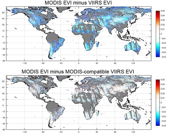
Spectral Cross-Calibration of VIIRS Enhanced Vegetation Index with MODIS: A Case Study Using Year-Long Global Data
by Kenta Obata, Tomoaki Miura, Hiroki Yoshioka, Alfredo R. Huete and Marco Vargas
Remote Sens. 2016, 8(1), 34; https://doi.org/10.3390/rs8010034 - 5 Jan 2016
Cited by 24 | Viewed by 7501
Abstract
In this study, the Visible Infrared Imaging Radiometer Suite (VIIRS) Enhanced Vegetation Index (EVI) was spectrally cross-calibrated with the Moderate Resolution Imaging Spectroradiometer (MODIS) EVI using a year-long, global VIIRS-MODIS dataset at the climate modeling grid (CMG) resolution of 0.05°-by-0.05°. Our cross-calibration approach [...] Read more.
In this study, the Visible Infrared Imaging Radiometer Suite (VIIRS) Enhanced Vegetation Index (EVI) was spectrally cross-calibrated with the Moderate Resolution Imaging Spectroradiometer (MODIS) EVI using a year-long, global VIIRS-MODIS dataset at the climate modeling grid (CMG) resolution of 0.05°-by-0.05°. Our cross-calibration approach was to utilize a MODIS-compatible VIIRS EVI equation derived in a previous study [Obata et al., J. Appl. Remote Sens., vol.7, 2013] and optimize the coefficients contained in this EVI equation for global conditions. The calibrated/optimized MODIS-compatible VIIRS EVI was evaluated using another global VIIRS-MODIS CMG dataset of which acquisition dates did not overlap with those used in the calibration. The calibrated VIIRS EVI showed much higher compatibility with the MODIS EVI than the original VIIRS EVI, where the mean error (MODIS minus VIIRS) and the root mean square error decreased from −0.021 to −0.003 EVI units and from 0.029 to 0.020 EVI units, respectively. Error reductions on the calibrated VIIRS EVI were observed across nearly all view zenith and relative azimuth angle ranges, EVI dynamic range, and land cover types. The performance of the MODIS-compatible VIIRS EVI calibration appeared limited for high EVI values (i.e., EVI > 0.5) due likely to the maturity of the VIIRS dataset used in calibration/optimization. The cross-calibration methodology introduced in this study is expected to be useful for other spectral indices such as the normalized difference vegetation index and two-band EVI. Full article
Show Figures

Graphical abstract

4893 KiB  
Article
Monitoring the NOAA Operational VIIRS RSB and DNB Calibration Stability Using Monthly and Semi-Monthly Deep Convective Clouds Time Series
by Wenhui Wang and Changyong Cao
Remote Sens. 2016, 8(1), 32; https://doi.org/10.3390/rs8010032 - 4 Jan 2016
Cited by 53 | Viewed by 7314
Abstract
The Visible and Infrared Imaging Radiometer Suite (VIIRS) onboard the Joint Polar Satellite System (JPSS)/Suomi National Polar-Orbiting Partnership (SNPP) satellite provide sensor data records for the retrievals of many environment data records. It is critical to monitor the VIIRS long-term calibration stability to [...] Read more.
The Visible and Infrared Imaging Radiometer Suite (VIIRS) onboard the Joint Polar Satellite System (JPSS)/Suomi National Polar-Orbiting Partnership (SNPP) satellite provide sensor data records for the retrievals of many environment data records. It is critical to monitor the VIIRS long-term calibration stability to ensure quality EDR retrieval. This study investigates the radiometric calibration stability of the NOAA operational SNPP VIIRS Reflective Solar Bands (RSB) and Day-Night-Band (DNB) using Deep Convective Clouds (DCC). Monthly and semi-monthly DCC time series for 10 moderate resolution bands (M-bands, M1–M5 and M7–M11, March 2013–September 2015), DNB (March 2013–September 2015, low gain stage), and three imagery resolution bands (I-bands, I1–I3, January 2014–September 2015) were developed and analyzed for long-term radiometric calibration stability monitoring. Monthly DCC time series show that M5 and M7 are generally stable, with a stability of 0.4%. DNB has also been stable since May 2013, after its relative response function update, with a stability of 0.5%. The stabilities of M1–M4 are 0.6%–0.8%. Large fluctuations in M1–M4 DCC reflectance were observed since early 2014, correlated with F-factor (calibration coefficients) trend changes during the same period. The stabilities of M8-M11 are from 1.0% to 3.1%, comparable to the natural DCC variability at the shortwave infrared spectrum. DCC mean band ratio time series show that the calibration stabilities of I1–I3 follow closely with M5, M7, and M10. Relative calibration changes were observed in M1/M4 and M5/M7 DCC mean band ratio time series. The DCC time series are generally consistent with results from the VIIRS validation sites and VIIRS/MODIS (the Moderate-resolution Imaging Spectroradiometer) simultaneous nadir overpass time series. Semi-monthly DCC time series for RSB M-bands and DNB were compared with monthly DCC time series. The results indicate that semi-monthly DCC time series are useful for stability monitoring at higher temporal resolution. Full article
Show Figures

Graphical abstract

2015

Jump to: 2020, 2019, 2018, 2017, 2016

3969 KiB  
Article
Improved Band-to-Band Registration Characterization for VIIRS Reflective Solar Bands Based on Lunar Observations
by Zhipeng Wang, Xiaoxiong Xiong and Yonghong Li
Remote Sens. 2016, 8(1), 27; https://doi.org/10.3390/rs8010027 - 31 Dec 2015
Cited by 20 | Viewed by 6115
Abstract
Spectral bands of the Visible Infrared Imaging Radiometer Suite (VIIRS) instrument aboard the Suomi National Polar-orbiting Partnership (S-NPP) satellite are spatially co-registered. The accuracy of the band-to-band registration (BBR) is one of the key spatial parameters that must be characterized. Unlike its predecessor, [...] Read more.
Spectral bands of the Visible Infrared Imaging Radiometer Suite (VIIRS) instrument aboard the Suomi National Polar-orbiting Partnership (S-NPP) satellite are spatially co-registered. The accuracy of the band-to-band registration (BBR) is one of the key spatial parameters that must be characterized. Unlike its predecessor, the Moderate Resolution Imaging Spectroradiometer (MODIS), VIIRS has no on-board calibrator specifically designed to perform on-orbit BBR characterization. To circumvent this problem, a BBR characterization method for VIIRS reflective solar bands (RSB) based on regularly-acquired lunar images has been developed. While its results can satisfactorily demonstrate that the long-term stability of the BBR is well within ±0.1 moderate resolution band pixels, undesired seasonal oscillations have been observed in the trending. The oscillations are most obvious between the visible/near-infrared bands and short-/middle wave infrared bands. This paper investigates the oscillations and identifies their cause as the band/spectral dependence of the centroid position and the seasonal rotation of the lunar images over calibration events. Accordingly, an improved algorithm is proposed to quantify the rotation and compensate for its impact. After the correction, the seasonal oscillation in the resulting BBR is reduced from up to 0.05 moderate resolution band pixels to around 0.01 moderate resolution band pixels. After removing this spurious seasonal oscillation, the BBR, as well as its long-term drift are well determined. Full article
Show Figures

Graphical abstract

2091 KiB  
Article
Comparison between the Suomi-NPP Day-Night Band and DMSP-OLS for Correlating Socio-Economic Variables at the Provincial Level in China
by Xin Jing, Xi Shao, Changyong Cao, Xiaodong Fu and Lei Yan
Remote Sens. 2016, 8(1), 17; https://doi.org/10.3390/rs8010017 - 25 Dec 2015
Cited by 84 | Viewed by 9645
Abstract
Nighttime light imagery offers a unique view of the Earth’s surface. In the past, the nighttime light data collected by the DMSP-OLS sensors have been used as an efficient means to correlate regional and global socio-economic activities. With the launch of the Suomi [...] Read more.
Nighttime light imagery offers a unique view of the Earth’s surface. In the past, the nighttime light data collected by the DMSP-OLS sensors have been used as an efficient means to correlate regional and global socio-economic activities. With the launch of the Suomi National Polar-orbiting Partnership (Suomi-NPP) satellite in 2011, the day-night band (DNB) of the Visible Infrared Imaging Radiometer Suite (VIIRS) onboard represents a major advancement in nighttime imaging capabilities, because it surpasses its predecessor DMSP-OLS in radiometric accuracy, spatial resolution and geometric quality. In this paper, four variables (total night light, light area, average night light and log average night light) are extracted from nighttime radiance data observed by the VIIRS-DNB composite in 2013 and nighttime digital number (DN) data from the DMSP-OLS stable dataset in 2012, respectively, and correlated with 12 socio-economic parameters at the provincial level in mainland China during the corresponding period. Background noise of DNB composite data is removed using either a masking method or an optimal threshold method. In general, the correlation of these socio-economic data with the total night light and light area of VIIRS-DNB composite data is better than with the DMSP-OLS stable data. The correlations between total night light of denoised DNB composite data and built-up area, gross regional product (GRP) and power consumption are higher than 0.9 and so are the correlations between the light area of denoised DNB composite data and city and town population, built-up area, GRP, power consumption and waste water discharge. However, the correlations of socio-economic data with the average night light and log average night light of VIIRS-DNB composite data are not as good as with the DMSP-OLS stable data. To quantitatively analyze the reasons for the correlation difference, a cubic regression method is developed to correct the saturation effect of the DMSP stable data, and we artificially convert the pixel value of the DNB composite into six bits to match the DMSP stable data format. The correlation results between the processed data and socio-economic data show that the effects of saturation and quantization are two of the reasons for the correlation difference. Additionally, on this basis, we estimate the total night light ratio between saturation-corrected DMSP stable data and finite quantization DNB composite data, and it is found that the ratio is ~11.28 ± 4.02 for China. Therefore, it appears that a different acquisition time is the other reason for the correlation difference. Full article
Show Figures

Graphical abstract

3491 KiB  
Article
Radiometric Stability Monitoring of the Suomi NPP Visible Infrared Imaging Radiometer Suite (VIIRS) Reflective Solar Bands Using the Moon
by Taeyoung Choi, Xi Shao, Changyong Cao and Fuzhong Weng
Remote Sens. 2016, 8(1), 15; https://doi.org/10.3390/rs8010015 - 25 Dec 2015
Cited by 38 | Viewed by 7585
Abstract
The Suomi NPP (S-NPP) Visible Infrared Imaging Radiometer Suite (VIIRS) performs the scheduled lunar roll maneuver on a monthly basis. The lunar calibration coefficients and lunar F-factor are calculated by taking the ratio of the lunar observed radiance to the simulated radiance from [...] Read more.
The Suomi NPP (S-NPP) Visible Infrared Imaging Radiometer Suite (VIIRS) performs the scheduled lunar roll maneuver on a monthly basis. The lunar calibration coefficients and lunar F-factor are calculated by taking the ratio of the lunar observed radiance to the simulated radiance from the Miller and Turner (MT) lunar model. The lunar F-factor is also validated against that derived from the VIIRS Solar Diffuser (SD). The MT model-based lunar F-factors in general agree with SD F-factors. The Lunar Band Ratio (LBR) is also derived from two channel lunar radiances and is implemented in the National Oceanic and Atmospheric Administration (NOAA) Integrated Calibration and Validation System (ICVS) to monitor the VIIRS long-term radiometric performance. The lunar radiances at pixels are summed for each of the VIIRS Reflective Solar Bands (RSBs) and normalized by the reference band M11 which has the most stable SD-based calibration coefficient. LBRs agree with the SD based F-factor ratios within one percent. Based on analysis with these two independent lunar calibration methods, SD-based and LBR-based calibrations show a lifetime consistency. Thus, it is recommended that LBR be used for both VIIRS radiometric calibration and lifetime stability monitoring. Full article
Show Figures

Graphical abstract

15734 KiB  
Article
User Validation of VIIRS Satellite Imagery
by Don Hillger, Tom Kopp, Curtis Seaman, Steven Miller, Dan Lindsey, Eric Stevens, Jeremy Solbrig, William Straka III, Melissa Kreller, Arunas Kuciauskas and Amanda Terborg
Remote Sens. 2016, 8(1), 11; https://doi.org/10.3390/rs8010011 - 24 Dec 2015
Cited by 9 | Viewed by 9130
Abstract
Visible/Infrared Imaging Radiometer Suite (VIIRS) Imagery from the Suomi National Polar-orbiting Partnership (S-NPP) satellite is the finest spatial resolution (375 m) multi-spectral imagery of any operational meteorological satellite to date. The Imagery environmental data record (EDR) has been designated as a Key Performance [...] Read more.
Visible/Infrared Imaging Radiometer Suite (VIIRS) Imagery from the Suomi National Polar-orbiting Partnership (S-NPP) satellite is the finest spatial resolution (375 m) multi-spectral imagery of any operational meteorological satellite to date. The Imagery environmental data record (EDR) has been designated as a Key Performance Parameter (KPP) for VIIRS, meaning that its performance is vital to the success of a series of Joint Polar Satellite System (JPSS) satellites that will carry this instrument. Because VIIRS covers the high-latitude and Polar Regions especially well via overlapping swaths from adjacent orbits, the Alaska theatre in particular benefits from VIIRS more than lower-latitude regions. While there are no requirements that specifically address the quality of the EDR Imagery aside from the VIIRS SDR performance requirements, the value of VIIRS Imagery to operational users is an important consideration in the Cal/Val process. As such, engaging a wide diversity of users constitutes a vital part of the Imagery validation strategy. The best possible image quality is of utmost importance. This paper summarizes the Imagery Cal/Val Team’s quality assessment in this context. Since users are a vital component to the validation of VIIRS Imagery, specific examples of VIIRS imagery applied to operational needs are presented as an integral part of the post-checkout Imagery validation. Full article
Show Figures

Graphical abstract

2422 KiB  
Article
Validation of the Suomi NPP VIIRS Ice Surface Temperature Environmental Data Record
by Yinghui Liu, Jeffrey Key, Mark Tschudi, Richard Dworak, Robert Mahoney and Daniel Baldwin
Remote Sens. 2015, 7(12), 17258-17271; https://doi.org/10.3390/rs71215880 - 18 Dec 2015
Cited by 8 | Viewed by 6929
Abstract
Continuous monitoring of the surface temperature is critical to understanding and forecasting Arctic climate change; as surface temperature integrates changes in the surface energy budget. The sea-ice surface temperature (IST) has been measured with optical and thermal infrared sensors for many years. With [...] Read more.
Continuous monitoring of the surface temperature is critical to understanding and forecasting Arctic climate change; as surface temperature integrates changes in the surface energy budget. The sea-ice surface temperature (IST) has been measured with optical and thermal infrared sensors for many years. With the IST Environmental Data Record (EDR) available from the Visible Infrared Imaging Radiometer Suite (VIIRS) onboard the Suomi National Polar-orbiting Partnership (NPP) and future Joint Polar Satellite System (JPSS) satellites; we can continue to monitor and investigate Arctic climate change. This work examines the quality of the VIIRS IST EDR. Validation is performed through comparisons with multiple datasets; including NASA IceBridge measurements; air temperature from Arctic drifting ice buoys; Moderate Resolution Imaging Spectroradiometer (MODIS) IST; MODIS IST simultaneous nadir overpass (SNO); and surface air temperature from the National Centers for Environmental Prediction/National Center for Atmospheric Research (NCEP/NCAR) reanalysis. Results show biases of −0.34; −0.12; 0.16; −3.20; and −3.41 K compared to an aircraft-mounted downward-looking pyrometer; MODIS; MODIS SNO; drifting buoy; and NCEP/NCAR reanalysis; respectively; root-mean-square errors of 0.98; 1.02; 0.95; 4.89; and 6.94 K; and root-mean-square errors with the bias removed of 0.92; 1.01; 0.94; 3.70; and 6.04 K. Based on the IceBridge and MODIS results; the VIIRS IST uncertainty (RMSE) meets or exceeds the JPSS system requirement of 1.0 K. The product can therefore be considered useful for meteorological and climatological applications. Full article
Show Figures

Graphical abstract

2546 KiB  
Article
Validation of S-NPP VIIRS Sea Surface Temperature Retrieved from NAVO
by Qianguang Tu, Delu Pan and Zengzhou Hao
Remote Sens. 2015, 7(12), 17234-17245; https://doi.org/10.3390/rs71215881 - 18 Dec 2015
Cited by 13 | Viewed by 8969
Abstract
The validation of sea surface temperature (SST) retrieved from the new sensor Visible Infrared Imaging Radiometer Suite (VIIRS) onboard the Suomi National Polar-Orbiting Partnership (S-NPP) Satellite is essential for the interpretation, use, and improvement of the new generation SST product. In this study, [...] Read more.
The validation of sea surface temperature (SST) retrieved from the new sensor Visible Infrared Imaging Radiometer Suite (VIIRS) onboard the Suomi National Polar-Orbiting Partnership (S-NPP) Satellite is essential for the interpretation, use, and improvement of the new generation SST product. In this study, the magnitude and characteristics of uncertainties in S-NPP VIIRS SST produced by the Naval Oceanographic Office (NAVO) are investigated. The NAVO S-NPP VIIRS SST and eight types of quality-controlled in situ SST from the National Oceanic and Atmospheric Administration in situ Quality Monitor (iQuam) are condensed into a Taylor diagram. Considering these comparisons and their spatial coverage, the NAVO S-NPP VIIRS SST is then validated using collocated drifters measured SST via a three-way error analysis which also includes SST derived from Moderate Resolution Imaging Spectro-radiometer (MODIS) onboard AQUA. The analysis shows that the NAVO S-NPP VIIRS SST is of high accuracy, which lies between the drifters measured SST and AQUA MODIS SST. The histogram of NAVO S-NPP VIIRS SST root-mean-square error (RMSE) shows normality in the range of 0–0.6 °C with a median of ~0.31 °C. Global distribution of NAVO VIIRS SST shows pronounced warm biases up to 0.5 °C in the Southern Hemisphere at high latitudes with respect to the drifters measured SST, while near-zero biases are observed in AQUA MODIS. It means that these biases may be caused by the NAVO S-NPP VIIRS SST retrieval algorithm rather than the nature of the SST. The reasons and correction for this bias need to be further studied. Full article
Show Figures

Graphical abstract

5510 KiB  
Article
Suomi NPP VIIRS Reflective Solar Bands Operational Calibration Reprocessing
by Slawomir Blonski and Changyong Cao
Remote Sens. 2015, 7(12), 16131-16149; https://doi.org/10.3390/rs71215823 - 2 Dec 2015
Cited by 25 | Viewed by 6632
Abstract
Radiometric calibration coefficients for the VIIRS (Visible Infrared Imaging Radiometer Suite) reflective solar bands have been reprocessed from the beginning of the Suomi NPP (National Polar-orbiting Partnership) mission until present. An automated calibration procedure, implemented in the NOAA (National Oceanic and Atmospheric Administration) [...] Read more.
Radiometric calibration coefficients for the VIIRS (Visible Infrared Imaging Radiometer Suite) reflective solar bands have been reprocessed from the beginning of the Suomi NPP (National Polar-orbiting Partnership) mission until present. An automated calibration procedure, implemented in the NOAA (National Oceanic and Atmospheric Administration) JPSS (Joint Polar Satellite System) operational data production system, was applied to reprocess onboard solar calibration data and solar diffuser degradation measurements. The latest processing parameters from the operational system were used to include corrected solar vectors, optimized directional dependence of attenuation screens transmittance and solar diffuser reflectance, updated prelaunch calibration coefficients without an offset term, and optimized Robust Holt-Winters filter parameters. The parameters were consistently used to generate a complete set of the radiometric calibration coefficients for the entire duration of the Suomi NPP mission. The reprocessing has demonstrated that the automated calibration procedure can be successfully applied to all solar measurements acquired from the beginning of the mission until the full deployment of the automated procedure in the operational processing system. The reprocessed calibration coefficients can be further used to reprocess VIIRS SDR (Sensor Data Record) and other data products. The reprocessing has also demonstrated how the automated calibration procedure can be used during activation of the VIIRS instruments on the future JPSS satellites. Full article
Show Figures

Graphical abstract

6940 KiB  
Article
Quality Assessment of S-NPP VIIRS Land Surface Temperature Product
by Yuling Liu, Yunyue Yu, Peng Yu, Frank M. Göttsche and Isabel F. Trigo
Remote Sens. 2015, 7(9), 12215-12241; https://doi.org/10.3390/rs70912215 - 21 Sep 2015
Cited by 61 | Viewed by 8537
Abstract
The VIIRS Land Surface Temperature (LST) Environmental Data Record (EDR) has reached validated (V1 stage) maturity in December 2014. This study compares VIIRS v1 LST with the ground in situ observations and with heritage LST product from MODIS Aqua and AATSR. Comparisons against [...] Read more.
The VIIRS Land Surface Temperature (LST) Environmental Data Record (EDR) has reached validated (V1 stage) maturity in December 2014. This study compares VIIRS v1 LST with the ground in situ observations and with heritage LST product from MODIS Aqua and AATSR. Comparisons against U.S. SURFRAD ground observations indicate a similar accuracy among VIIRS, MODIS and AATSR LST, in which VIIRS LST presents an overall accuracy of −0.41 K and precision of 2.35 K. The result over arid regions in Africa suggests that VIIRS and MODIS underestimate the LST about 1.57 K and 2.97 K, respectively. The cross comparison indicates an overall close LST estimation between VIIRS and MODIS. In addition, a statistical method is used to quantify the VIIRS LST retrieval uncertainty taking into account the uncertainty from the surface type input. Some issues have been found as follows: (1) Cloud contamination, particularly the cloud detection error over a snow/ice surface, shows significant impacts on LST validation; (2) Performance of the VIIRS LST algorithm is strongly dependent on a correct classification of the surface type; (3) The VIIRS LST quality can be degraded when significant brightness temperature difference between the two split window channels is observed; (4) Surface type dependent algorithm exhibits deficiency in correcting the large emissivity variations within a surface type. Full article
Show Figures

Graphical abstract

Back to TopTop